Download
1 / 27
270 likes | 408 Views
Introduction to GEON and iGEON. Chaitan Baru. GEON: The Geosciences Network. www.geongrid.org. GEON is a coalition among IT and Earth Science researchers with the goal of developing advanced information technologies to enable new modes of geosciences research

E N D
Introduction to GEON and iGEON Chaitan Baru
GEON: The Geosciences Network www.geongrid.org • GEON is a coalition among IT and Earth Science researchers with the goal of developing advanced information technologies to enable new modes of geosciences research • GEON is developing technologies for information integration and knowledge discovery • Project participants: 14 PI institutions, and partners including, other projects, agencies, and industry • GEON has deployed a Web services-based, distributed computing infrastructure, called the GEONgrid, across PI and partner sites • GEONgrid provides access to data collections, tools, and applications that support geosciences research • Project funding: $11.25M, 2002-2007 RESEARCH AND EDUCATION PRODUCTS AND RESULTS • Technologies for Ontology-Based Data Registration, GIS Map Integration, Distributed Portals, and 4D Visualization • Research on • 3D Lithospheric structure • Gravity Modeling • Remote Sensing Data Integration • Cyberinfrastructure Summer Institute for Geoscientists and graduate courses in Geoinformatics
GEON Partners PI Institutions Arizona State University Bryn Mawr College Penn State University Rice University San Diego State University San Diego Supercomputer Center/UCSD University of Arizona University of Idaho University of Missouri, Columbia University of Texas at El Paso University of Utah Virginia Tech UNAVCO Digital Library for Earth System Education (DLESE) Partners Chronos CUAHSI-HIS ESRI California Institute for Telecommunications and Information Technology, Calit2 Georgia State University Geological Survey of Canada Georeference Online HP IBM Lawrence Livermore National Laboratory NASA Goddard, Earth System Division Southern California Earthquake Consortium (SCEC) U.S. Geological Survey (USGS) Purdue University Affiliated Projects EarthScope, IRIS • 14 PI institutions • Over 20 other partners including, universities, industry, government agencies/labs
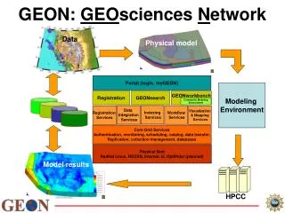
GEON Portal GEON Portal and Cyberinfrastructure provide: Authenticated access to data and Web services Registration of data sets, tools, and services with metadata Search for data, tools, and services, using ontologies Scientific workflow environment and access to HPC Data and map integration capability Scientific data visualization and GIS mapping
Key Informatics Areas • Portals • Authenticated, role-based access to cyber resources: data, tools, models, model outputs, collaboration spaces, … • Data Integration • Search, discovery and integration of data from heterogeneous information sources (“mediation” and “semantic integration”) • Use of workflow systems, and access to HPC • Ability to “program” at a higher level of abstraction • Sharing of models, along with “provenance” information • Gateways to HPC environments • Management of Geospatial Information • Using GIS capabilities, map services, geospatial data integration • Visualizationof 3D, 4D geospatial data and information
GEON LiDAR Workflow (GLW) Portlet • GEON will also host EarthScope LiDAR data and • TLS (ground-based LiDAR) data from the INTERFACE • project
International GEON Activities • Characteristics of international collaborations • Mutually beneficial: data publication, access to tools, access to resources, joint technology development • Involve CS/IT and Geosciences collaborators • With universities and/or national labs • PRAGMA: Pacific Rim Assembly for Grid Middleware Applications • GEON is a project supported by PRAGMA • GEON co-chairs the PRAGMA Geosciences Working Group • Japan • Collaboration with AIST’s GEO Grid project • Sharing of technology and data. Use of GEON LiDAR data to validate GEO Grid ASTER-based DEMs • China • GEON Workshop, October 2006, Beijing. Co-sponsored by Chinese Academy of Sciences. • Collaborations in developing parallelized geodynamics codes
International GEON Activities • Russia • GEON Workshop, July 2007, Moscow. Co-sponsored by Russian Academy of Sciences • Possible collaborations in grid computing and XML databases • India • Joint project with University of Hyderabad, funded by the Indo-US Science and Technology Forum ($100K/2 years) • GEON workshops in October 2005 and August 2007 • Visits by US collaborators to India, and vice versa; visit by Indian PhD student to US; identification of Master’s thesis projects in India • iGEON-India network in India
GEON 2.0 Use Case Scenario • Derived 3D volumetric model • Multiple isosurfaces, with different transparencies • Slices through the volume • Variable gridding: data typically has lower resolution at greater depths • 2D surface data: Satellite imagery, street maps, geologic maps, terrain surface, fault lines, and other derived features etc. • allow a lower layer, such as a gravity map, to show through • terrain can be shown alone, or integrated with volume and interface models to aid correlations. • Bore hole or well data • provides record of the rock types encountered at different depths at a sample location. The data are important in resolving ambiguities in the inferred interfaces from other data. • show sample locations as icons atop the terrain, and as well paths drawn downward through the model • sample locations will be scattered across a region and may provide definitive interface data in only some areas. • “For a given region (i.e. lat/long extent, plus depth), return a 3D structural model with accompanying physical parameters of density, seismic velocities, geochemistry, and geologic ages, using a cell size of 10km”
GEON 2.0: OpenEarth Framework GEON 2.0 GEON1 Metadata Catalog Interop Protocol
Portal Requirements Portal Portal Portlets Portlets Portlets Portlets Portlet Portlet “Federated Portals” Central resources Portal Portlets Portlets Core services (portlets): authentication, search, workspace Portlet Aggregation Distributed resources
Leveraging of GEON by other projects • NEES • CBEO • HIS • NEON Testbed • Archeoinformatics • Tropical Ecology (TEAM) • EarthScope
EarthScope Data Portal Backend Backend Backend
ES Portal Screen Snapshot: Response to a station discovery query
ES Portal Screenshot: Stations in a given region for specified Data Classes
Ontology-EnabledData Integration: Geologic Maps domain knowledge Show formations where AGE = ‘Paleozic’ (without age ontology) Knowledge representation Geologic Age ONTOLOGY Show formations where AGE = ‘Paleozic’ (with age ontology) +/- a few hundred million years Nevada
Data Registration Spatial Ontology Location Rock Classification Ontology Igneous Point Polygon Granite Quartzmonzonite Latitude Longitude (X, Y) Lat, Long, RockType Metadata Gravity dataset Geologic dataset Metadata Schema registration Item Registration
Ontology Enabled Data Integration ontology3 Ontology1 Ontology2 dataset1 dataset2 dataset3 dataset4 • Ontology Enabled Semantic Integration • Challenges for Computer Scientists and Domain Scientists • Computer Scientists: build an integration system based on the ontological registration of datasets • Domain Scientists: create domain ontologies • Data Providers: register datasets to ontologies
Registering Tables to Ontology Object Properties • Associate two entities which are already registered to the domain class and the range class of a selected object property in the ontology hasAge Rock GeologicAge
ODAL: Ontological Database Annotation Language <odal:NamedIndividuals odal:id="RockSample" odal:database="VTDatabase"> <odal:Class odal:resource="http://geon.vt.edu#RockSample" /> <odal:Table>Samples</odal:Table> <odal:Table>RockTexture</odal:Table> <odal:Table>RockGeoChemistry</odal:Table> <odal:Table>ModalData</odal:Table> <odal:Table>MineralChemistry</odal:Table> <odal:Table>Images</odal:Table> <odal:Column>ssID</odal:Column> </odal:NamedIndividuals> GUI generate to ODAL processor • Create a partial model of ontologies from database • Independent on any GUI • Independent on any concrete implementations • reusable The values in the column ssID of the table Samples, RockTexture, RockGeoChemistry, ModalData,MineralChemistry and Images represent instances of RockSample
SOQL(Simple Ontology Query Language) location RockSample Location hasSiO2 lat long value float ValueWithUnit unit SELECT X.location.*; FROM RockSample X WHERE X.location.lat > 60 AND X.location.long > 100 AND X.hasSiO2.value < 30 AND X.hasSiO2.unit =‘weightPercetage’ string GUI generate to SOQL processor • Query single or integrated resources • via ontologies (i.e., high level logical views) • independent on any physical presentation (i.e. schemas)