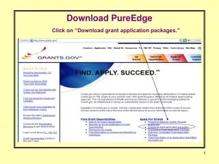
Download
1 / 39
390 likes | 562 Views
EDINA Digimap’s OS Collection: Boundary Download Vivienne Carr James Crone. Meeting content. Digimap’s OS Collection Data Download Services Digimap’s OS Collection Boundary Download: What’s available? Code-point Code-point Polygons OS Boundary Line

E N D
EDINA Digimap’s OS Collection: Boundary Download Vivienne Carr James Crone
Meeting content • Digimap’s OS Collection Data Download Services • Digimap’s OS Collection Boundary Download: • What’s available? • Code-point • Code-point Polygons • OS Boundary Line • GB National Boundaries and GB National Grids • Onward use of data • Unzip data files • Data formats & conversion • Desktop sharing Digimap Training Workshops
Meeting content • Digimap’s OS Collection Data Download Services • Digimap’s OS Collection Boundary Download: • What’s available? • Code-point • Code-point Polygons • OS Boundary Line • GB National Boundaries and GB National Grids • Onward use of data • Unzip data files • Data formats & conversion • Desktop sharing Digimap Training Workshops
Data Download Services • Accessed from Digimap’s OS Collection Home page Digimap Training Workshops
Data Download Services • Data Download • MasterMap Download • Boundary Download • Gazetteer Download • Gazetteer Plus Digimap Training Workshops
OS Products available http://www.edina.ac.uk/digimap/description/products/ Digimap Training Workshops
Meeting content • Digimap’s OS Collection Data Download Services • Digimap’s OS Collection Boundary Download: • What’s available? • Code-point • Code-point Polygons • OS Boundary Line • GB National Boundaries and GB National Grids • Onward use of data • Unzip data files • Data formats & conversion • Desktop sharing Digimap Training Workshops
Boundary Download Home Page • OS Code-Point – postcode listings or postcode polygons • OS Boundary lines – e.g. counties, unitary authorities, electoral areas • National GB boundaries Digimap Training Workshops
Date of last updates by OS • Code-Point, March 2009 • Boundary Line: • April 2009, NTF format • May 2009, other formats • Put into Digimap service in September 2009 Digimap Training Workshops
Meeting content • Digimap’s OS Collection Data Download Services • Digimap’s OS Collection Boundary Download: • What’s available? • Code-point • Code-point Polygons • OS Boundary Line • GB National Boundaries and GB National Grids • Onward use of data • Unzip data files • Data formats & conversion • Desktop sharing Digimap Training Workshops
Code-Point • OS Code-Point: National Grid co-ordinates for a point within each postcode unit in Great Britain • OS Code-Point Polygons: Digital postcode unit boundaries • Available at area level (e.g. AB, CF) or district level (AB1, AB2 etc). District level not available in NTF format. Digimap Training Workshops
Code-Point at Area level • Can select up to 5 postal areas • Vertical streets included in area files Digimap Training Workshops
Code-Point at District level • First, select an area Digimap Training Workshops
Code-Point at District level • Then select the districts of interest • Separate vertical street file provided for entire area, when you download district files Digimap Training Workshops
Code-Point data • Also provided: NHS region, NHS authority, County, District, Ward, Postcode Type Digimap Training Workshops
Code-Point • Code-point data, on 1:10000 Scale Raster background Digimap Training Workshops
Code-Point Polygons • Code-Point data and Code-Point Polygons, on 1:10000 Scale Raster background Digimap Training Workshops
Meeting content • Digimap’s OS Collection Data Download Services • Digimap’s OS Collection Boundary Download: • What’s available? • Code-point • Code-point Polygons • OS Boundary Line • GB National Boundaries and GB National Grids • Onward use of data • Unzip data files • Data formats & conversion • Desktop Sharing Digimap Training Workshops
Boundary Line • Available: County, European constituencies, Greater London Authority, Metropolitan districts, Scottish parliamentary electoral region, Unitary Authorities, Westminster constituencies, Extent of the realm • Boundary datasets for use with census datasets, available in UKBORDERS: http://edina.ac.uk/ukborders/ Digimap Training Workshops
OS Boundary Line – SHP or MIF/MID • Select boundary type > Receive one chosen boundary type for all areas Digimap Training Workshops
OS Boundary Line - NTF • Select area > Receive all boundary types for one area Digimap Training Workshops
Boundary Line • Scotland and Wales Constituencies, 1:25000 Raster background of Edinburgh area Digimap Training Workshops
Boundary Line • Greater London Constituencies, labelled, 1:25000 Raster background Digimap Training Workshops
Meeting content • Digimap’s OS Collection Data Download Services • Digimap’s OS Collection Boundary Download: • What’s available? • Code-point • Code-point Polygons • OS Boundary Line • GB National Boundaries and GB National Grids • Onward use of data • Unzip data files • Data formats & conversion • Desktop sharing Digimap Training Workshops
GB National Boundaries & Grids • National Boundaries have been derived from Ordnance Survey’s Strategi data • National Grids have been created by Ordnance Survey Digimap Training Workshops
GB National Boundaries • 4 options – GB, England, Scotland, Wales Digimap Training Workshops
GB National Grids • 4 options – 1km, 5km, 10km, 100km Digimap Training Workshops
Meeting content • Digimap’s OS Collection Data Download Services • Digimap’s OS Collection Boundary Download: • What’s available? • Code-point • Code-point Polygons • OS Boundary Line • GB National Boundaries and GB National Grids • Onward use of data • Unzip data files • Data formats & conversion • Desktop sharing Digimap Training Workshops
Unzip process 1. Data.zip • 2. Unzip Data.zip: • Contents.txt, • Conditions.txt, • Data files Digimap Training Workshops
Contents of Code-point download Digimap Training Workshops
Meeting content • Digimap’s OS Collection Data Download Services • Digimap’s OS Collection Boundary Download: • What’s available? • Code-point • Code-point Polygons • OS Boundary Line • GB National Boundaries and GB National Grids • Onward use of data • Unzip data files • Data formats & conversion • Desktop sharing Digimap Training Workshops
Data formats • CSV – Comma Separated Values • DXF – Drawing Exchange Format • SHP – ArcView Shapefile • MIF/MID – Map Info Interchange format • NTF – National Transfer Format Digimap Training Workshops
CSV format • Necessary to convert a CSV file to a DBF 4 file, prior to import to ArcGIS • Can do this in MS Office 2003, but not in MS Office 2007 • A possible workaround is to open the CSV file with Open Office, then save as DBF Digimap Training Workshops
Save CSV as DBF4 Digimap Training Workshops
Save CSV as DBF4 Digimap Training Workshops
Shape files • Shape files do not require any conversion prior to use in ArcGIS • Remember to keep all files together - SHP, PRJ, DBF, SHX: Digimap Training Workshops
NTF format • Conversion will be required before use in ArcGIS • ESRI Productivity Suite (ArcGIS V9.2 or later) – this must be requested from CHEST separately, via your institutional CHEST representative. • Map Manager (ArcGIS V9.1 or earlier) • Either of these tools can be used to convert NTF files to ESRI Personal Geodatabase format Digimap Training Workshops
Meeting content • Digimap’s OS Collection Data Download Services • Digimap’s OS Collection Boundary Download: • What’s available? • Code-point • Code-point Polygons • OS Boundary Line • GB National Boundaries and GB National Grids • Onward use of data • Unzip data files • Data formats & conversion • Desktop sharing Digimap Training Workshops
Resources • Digimap OS Collection Help pages– Boundary Download: • Download instructions • Code-Point and Code-Point Polygons user guides • Using NTF data with ArcGIS v3.x • Using NTF data with ArcGIS v9.x • EDINA Training guides: http://edina.ac.uk/digimap/support/training/ • Ordnance Survey website: • General product information: http://www.ordnancesurvey.co.uk/oswebsite/products/ Digimap Training Workshops