Download
1 / 26
260 likes | 382 Views
Digital Gazetteers in the UK : the geo-X-walk Project at EDINA. Presented by: Andy Corbett (Development Engineer) James S Reid (Project manager) 18.7.02. Roadmap. Context - JISC , EDINA & gazetteers Gazetteer Content Technical and Implementation Issues The future.

E N D
Digital Gazetteers in the UK : the geo-X-walk Project at EDINA Presented by: Andy Corbett (Development Engineer) James S Reid (Project manager) 18.7.02
Roadmap • Context - JISC , EDINA & gazetteers • Gazetteer Content • Technical and Implementation Issues • The future...
EDINA*(Edinburgh Data and Information Access) a JISC-funded national datacentre based at the University of Edinburgh,Scotland offers the UK tertiary education and research community networked access to a library of data, information and research resources. services are available free of charge to members of UK tertiary education institutions for academic use, although institutional subscription and end-user registration are required for most services. 30+ services - bibliographic,MPS and geo Service focus + development project-to-full service strand * "Edina" is also the ancient and poetic name for Edinburgh, Scotland. Robert Burns wrote "Address To Edinburgh", which begins, "Edina! Scotia's darling seat!"
The Joint Information Systems Committee (JISC) is the strategic advisory committee for the UK academic sector. The JISC Information Environment is… • a national digital library... for higher and further education • a managed collection of resources • a distributed resource supporting learning and research in the UK • heterogeneous… bibliographic, images, data, video, geo-spatial, etc. • an information environment that enables people to discover, access and use a wide variety of quality assured resources • simple underlying functional model of the Information Environment - discover, access, use, publish JISC are interested in applying this model to geographic information and also desire to look for ways to enable geographic searching of the Information Environment
geo-X-walk - a gazetteer service Digital Gazetteer -An electronic list of geographic features together with their associated spatial location Digital Gazetteer Service -A network-addressable middle-ware server supporting geographic referencing and searching aim: develop a demonstrator gazetteer service suitable for extension to full service a shared service within the JISC IE phase II demonstrator project - commenced June 2002 builds on the ideas of the ADL
geo-X-walk : Overview • similar to the ADL approach (Linda Hill et al) • structural model: metadata model v. hierarchical thesaurus • emphasis on implicit spatial relationships over explicitly stated relationships • represent objects by correct geometry • feature type thesaurus important • merge data from various sources • comprehensive description but with small set of core elements • temporal aspects of names, footprints, relationships, … • document source, spatial accuracy/scale of footprint • technically challenging and many data related issues….
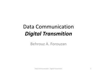
Information server Information server Geo-parsing & indexing Searching The geo-X-walk Server Reference use
Assist information services with searching • geographic searching is an important and powerful information retrieval facility • need to support a full range of geographic search options • more efficient to map a user view to native spatial coding scheme • use implicit spatial relationships to ‘cross-walk’ between geographies • machine to machine interaction (m2m)
Geo-parsing and indexing • increasing demand from data providers, archives, libraries, and museums to support geographic searching • BUT large number of information resources NOT geographically indexed • assist in the geo-referencing of information objects • parse documents, metadata records etc. to identify geographic names, features and other geographies • semi automatic indexing • ideally everyone should use standard spatial coding scheme • why? Because wide variety of geographies exist which change over time! • geographic coordinates preferred choice i.e GB National Grid /lat long • convert into geographic 'footprints’
Reference Use - Example queries Where is Ormskirk? What is the county town of Shropshire? What is at grid ref. NT 258 728? List me all places ending with ‘chester’ What parishes fall within the Lake District National Park? On what river is Liverpool situated? Which Roman roads pass through Leicestershire? By what alternative names has York been known?
Anticipated uses of gazetteer service • Reference source for researchers, libraries and museums • Assist metadata creators • Convert different geographic identifiers to standard coding scheme • Geo-parser for semi-automatic indexing • Facilities to resolve variant names etc. • Provide services with means to support full range of spatial searching • no need to hold data to resolve spatial query • Interest outside academic sector
Roadmap (reprise) • Gazetteer Content • Technical and Implementation Issues • The future...
Edina Gazetteer • 4 ‘M’s: • Multi-source • Multi-scale • Metadata model • Multi-problem! • ‘Near contemporary’ focus
Boundary data - EDINA UKBORDERS service • Contemporary places - Ordnance Survey • 1:50,000 (medium scale) Placename Gazetteer • 1:1250 (large scale,cartographic) Land-line product • Additional features - range of OS products • miscellaneous ‘special’ gazetteers • e.g. GB Waypoints • a gazetteer of Cold War sites in the UK
Before we started... • Major Issues of: • Complexity • Feature Typing • Positional accuracy • Alternative Names • Time stamping • Data incompleteness
In particular... • Boundary Complexity • Over digitisation => thousands of points in a geometry • ‘Region’ polygons (i.e. > 1 polygon) • Different sources, different scales - which is ‘correct’? • Placename Problems • Cartographic vs geographical placement • Feature typing - high proportion of ‘miscellaneous’ features • Placename changes through time • Alternate names e.g. multilingual representations • Licensing • Stakeholder involvement • Terms and conditions of use
Gazetteer Architecture • ADL Model • Modified ADL Feature Type Thesaurus • Ingres Relational Database • Spatial Searching
The Future • Continue database population • Benchmarking alternative implementations - bespoke/Oracle/Laser-scan • Interfaces - human:machine / machine:machine • Data issues - rights to data / limitations of use
Contacts and More Info @ http://edina.ac.uk EDINA Data Library George Square University of Edinburgh EH8 9LJ Scotland,UK Tel: +44 (0)131 651 1383 Fax: +44 (0)131 650 3308 James Reid james.reid@ed.ac.uk
Contacts and More Info @ EDINA http://edina.ac.uk Data Library George Square University of Edinburgh EH8 9LJ Scotland,UK Tel: +44 (0)131 651 1383 Fax: +44 (0)131 650 3308 James S Reid james.reid@ed.ac.uk
Statistical Account of Scotland NUMBER XIII. PARISH OF CULLEN. (COUNTY OF BANFF, SYNOD OF ABERDEEN, PRESBYTERY OF FORDYCE.) By the Rev. Mr. ROBERT GRANT. Royalty, Extent, Climate, etc. CULLEN, as appears from old charters, was originally called Inverculan, because it stands upon the bank of the Burn of Cullen, which, at the N. end of the town, falls into the sea: but now it is known by the name of Cullen on- ly. Cullen is a royal burgh, formerly a constabulary, of which the Earl of Findlater was hereditary constable. The set, as it is called, of the council, consists of 19, in which num- ber are included the Earl of Findlater, hereditary preses, 3 bailies, a treasurer, a dean-of-guild, and 13 counsellors. The parish extends from the sea fouthward, about 2 English miles in length. • Geo-spatial data • “data that have some form of spatial or geo-graphic reference that enables them to be located in two- or three-dimensional space”
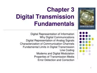
Provision layer Fusion layer geo-X-walk Presentation layer JISC Information Environment Content providers Shared services Authentication Authorisation Broker/Aggregator Collect’n Desc Portal Go-Geo! Portal Portal Service Desc Resolver Inst’n Profile End-user
content provider profiles Gazetteer Server initiate search ('Edinburgh') crosswalk spatialcomponent Content Provider 4 Content Provider 2 Content Provider 3 Content Provider 1 return result set Geo-parser Server content spatially indexed Go-Geo! Portal geo-X-walk geo-X-walk geo-parse records (exp) customised requests content not spatially indexed Example application JISC IE