Download
1 / 32
320 likes | 492 Views
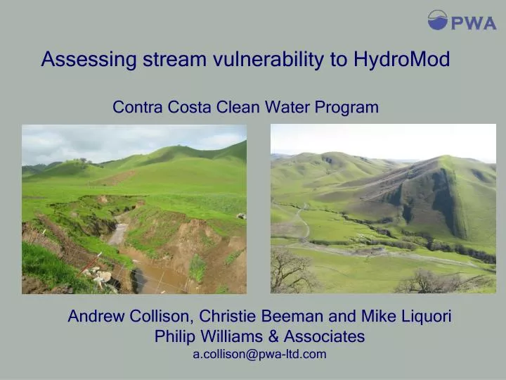
Assessing stream vulnerability to HydroMod Contra Costa Clean Water Program. Andrew Collison, Christie Beeman and Mike Liquori Philip Williams & Associates a.collison@pwa-ltd.com. Origin and description of low, medium, and high risk streams Classification rationale

E N D
Assessing stream vulnerability to HydroMod Contra Costa Clean Water Program Andrew Collison, Christie Beeman and Mike Liquori Philip Williams & Associates a.collison@pwa-ltd.com
Origin and description of low, medium, and high risk streams Classification rationale Basic Geomorphic Assessment classification examples Comprehensive Assessment Examples of mitigation projects vs. comprehensive analysis and restoration Outline
Compare pre- to post-project imperviousness (Option 1) No Action Project Proposal Existing Impervious Area & conveyance efficiency N Increase ? Y Site Design Proposed Impervious Area & conveyance efficiency Go to next Step
Develop and evaluate BMPs Select and size on-site IMPs using guidebook Sizing Tool(Option 2) Site planning and evaluation No Mitigation Partial Mitigation 100% Mitigation Develop alternative on-site mitigation plan and analysis (Option 3) Stop Assess Stream Vulnerability (Option 4)
Comprehensive geomorphic assessment Yes No Comprehensive analysis; possible restoration plan Is channel continuouslyhardened, tidal ordepositional between outletand bay? Detailed analysis; In-stream mitigation plan Yes Low Exempt from HMP Risk of Increased Erosion and Impacts Management action: allows in-stream measures in lieu of on-site mitigation High Basic geomorphic assessment No Medium Assess stream vulnerability to erosion Project larger than 20 acres?
Defining ‘High, medium and low’ vulnerability Risk of Increased Erosion and Impacts Develop a scientific basis for discriminating medium and high. Must be objective, repeatable, easy for applicant to implement and for permit grantor to check. Field Evaluation & Review Of Available Data High Medium Armored flood control channels, channels within the tidal zone (C.3.f.ii. guidelines) Low Require basic on-site BMPs (to MEP)
Stream erosion is most likely to follow HydroMod where: Small increases in flow lead to large increases in shear stress (shear stress sensitivity) Small increases in shear stress lead to large increases in erosion (low channel resistance) Conceptual approach for basic assessment
Conceptual approach for basic assessment Wide shallow channel – little increase in shear stress with Q. Q2 dissipates over floodplain Increasing vulnerability Narrow deep channel – large increase in shear stress with Q. Q2 confined in channel.
Conceptual approach for basic assessment Increasing channel vulnerability Coarse sediment and vegetated channel less erosion-prone Fine sediment and unvegetated channel more erosion-prone
Turning concepts into measurable attributes Increasing vulnerability resistant sediment, not very entrenched non resistant sediment, not very entrenched Increasing channel vulnerability resistant sediment, highly entrenched non resistant sediment, highly entrenched
Identifying parameters and threshold values • Assessed 20 stream sites in Contra Costa County • Use best professional judgment to make initial risk assessment • Measured numerous relevant field parameters • Identified type and thresholds of field data that objectively led to same results as the professional judgment
Reconnaissance: test streams Marsh Creek near Oakley Low gradient flood channel Low Risk Note however: channel misclassified as riprap in GIS (applicants will need to ground truth)
Reconnaissance: test streams Marsh Creek near Marsh Creek reservoir Low-moderate gradient, natural channel, eroding outside bends Medium Risk Some excess energy can be expended on floodplain and vegetation, but limited potential for lateral erosion
Reconnaissance: test streams Upper Marsh Creek medium gradient, confined channel High Risk Excess energy directed to eroding bank
Turning concept into measurable attributes Entrenchment Ratio = (Floodprone Area Width*) / (Bankfull Width) Floodprone width = width at 2 x bankull depth Note: Rosgen definitions of degree of entrenchment differ from those used here Floodprone width ER > 1.6 – channel is non entrenched Bankfull depth Bankfull width Floodprone width ER < 1.6 – channel is entrenched Bankfull depth Bankfull width
Turning concept into measurable attributes Entrainment ratio = critical diameter for entrainment/bed diameter If dc > size class of bed, channel is non-resistant If dc < size class of bed, channel is resistant Critical bed diameter for entrainment, dc = 13.7 x depth x slope
Primary and secondary vulnerability criteria If both primary criteria indicate the same vulnerability class, that class is adopted. If primary criteria disagree, use preponderance of secondary criteria. In 2/3rds of cases (n=20) this initial test led to a decisive result that was in agreement with the field judgment
Less standardized to meet site specifics A detailed assessment should identify those geomorphic and hydrologic processes that contribute to channel stability, evaluate how the project will affect these processes, and assess how changes in these processes will affect long-term channel response Likely to involve historic assessment, hydrology and hydraulic assessment, possible sediment transport modeling of pre and post-development erosion processes Comprehensive geomorphic assessment
Example – prediction of post HydroMod channel gradient Rural, no HydroModified channels Urban, HydroModified channels e.g. for 3 mile watershed stable channel would flatten from 0.015 to 0.008
Determine post HydroMod stresses and develop appropriate stabilization Source: http://www.wes.army.mil/el/emrrp/tnotes2.html
Mitigation on ‘medium’ and ‘high’ risk streams • Basic assessment can provide some guidance on mitigation, but more assessment and design analysis will be needed • Modify channel so that attributes indicate greater stability – e.g. lower floodplain to increase entrainment ratio, - e.g. increase sinuosity to reduce entrainment ratio
Mitigation on a ‘high risk’ stream Create floodplain to reduce shear stress sensitivity and increase habitat function
Mitigation on a ‘high risk’ stream Immediately after installation Grade controls prevent incision and reduce shear stress sensitivity. Lower gradient reduced entrainment ratio. Three years after installation
Mitigation on a ‘medium risk’ stream Floodplain inset bench lowering – reduces stress and creates habitat
Mitigation on a ‘medium risk’ stream Root wad revetment – increases resistance, reduces stress downstream and creates habitat Combination of LWD revetment and willow mattress
For small developments relatively simple field indicators can be used to quickly classify the majority of streams into risk categories Larger developments or more complex stream systems require more sophisticated predictive approaches Mitigation should address the underlying cause of erosion, avoid tendency to harden as mitigation However, there are not good long term studies of creeks before and after HydroMod to validate any of the approaches out there Especially difficult assessing erosion risk of cohesive channels as erodibility is hard to measure Summary


![To His Coy Mistress – Andrew Marvel [ 1650]](https://cdn1.slideserve.com/1958672/to-his-coy-mistress-andrew-marvel-1650-dt.jpg)