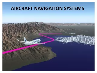
Air Navigation Systems Management and Control
Learn about automatic navigation systems, planning, air traffic control, and flow management in the aviation industry. Explore techniques, data preparation, quality control, and aids for flight and ground navigation.

Air Navigation Systems Management and Control
E N D
Presentation Transcript
Management, planning and air traffic control Important feature of navigation processes are operation in incomplete information about state of aircraft and external environment. It is result from uncertain weather processes and navigation measurement errors. Accurate, reliable and safe air navigation is provided by four interrelation processes are controlling separate functional systems • technique management and administration of air navigation; • dataware and navigation preparation for the flight; • avigation; • avigation quality control.
Air navigation is succession modes of route calculation to changing each other during correction of the coordinates. • Flight navigation aids can be divided to facilities of route calculation and position data accessing equipment (physical coordinates). • Base of traditional facilities are information from compass system, Doppler navigator of velocity and gliding angle, air data computer (ADC) and digital or analogue navigation computer for processing data in geographical coordinate systems. • Positional (fix) aids are nondirectional beacon (NDB), locator, outer (medium , inner) marker, VOR/DME, radio aids for short-range navigation (РСБН), runway boundary beacon and airborne (flight) and ground radar systems
Air Traffic Flow Management (ATFM) is the regulation of air traffic in order to avoid exceeding ATC capacity in handling traffic, and to ensure that available capacity is used efficiently.
Flow management procedures ATFM should be carried out in three phases: • strategic planning, if the action is carried out more than one day before the day on which it will take effect. Strategic planning is normally carried out well in advance, typically two to six months ahead; • pre-tactical planning, if the action is to be taken on the day before the day on which it will take effect; • tactical operations, if the action is taken on the day on which it will take effect.
Navigation Critical time Intrusion ATC surveillance Communication Traffic flow rate Track configuration Collision risk = f(navigation, track configuration, traffic flow rate(intensity), communication, air traffic control)
Area Navigation (RNAV) is a method of air navigation that allows an aircraft to choose any course within a network of navigation beacons, rather than navigating directly to and from the beacons. This can conserve flight distance, reduce congestion, and allow instrumentflight plans into airports without beacons. • RNAV was reanimated after the large-scale introduction of satellite navigation. • Area Navigation (RNAV) can be defined as a method of navigation that permits aircraft operation on any desired course within the coverage of station-referenced navigation signals or within the limits of a self contained system capability, or a combination of these.
Navigation systems which provide RNAV capabilityinclude • VOR/DME • DME/DME • LORAN C or CHAYKA (on august, 2010 were shut down) • MLAT • GPS • OMEGA • self contained Inertial Navigation Systems (INS) or Inertial Reference Systems (IRS).
VOR symbols. • VHF Omni-directional Radio Range is radio navigation system for aircraft. A VOR ground station broadcasts a VHFradio composite signal that allows the airborne receiving equipment to derive a bearing from the station to the aircraft
VOR/DME • A common general aviation RNAV system is the track-line computer (TLC), based on azimuth and distance information from a VORTAC. With the track-line computer the pilot effectively moves or off-sets the VORTAC to any desired location if it is within reception range. This "phantom station" is created by setting the distance (RHO) and the bearing (THETA) of the waypoint from a convenient VORTAC in the appropriate windows of the waypoint selector. A series of these"phantom stations" or waypoints make up an RNAV route.
LORAN-C(ceased transmitting signals in 2010) • LORAN-C is a pulsed hyperbolic system operating in the 90 to 110 kilohertz (kHz) frequency band which is used for marine and air navigation where signal coverage is available. The system is based upon the measurement of the time difference in the arrival of signal pulses from a group or chain of stations. A chain consists of a master station linked to a maximum of four secondary stations with all of the signals synchronized with the master. The LORAN-C receiver measures the time difference between the master and at least two of the secondaries to provide a position fix.
OMEGA Network Omega is a network of eight VLF transmitting stations located throughout the world to provide worldwide signal coverage for marine and air navigation. These stations transmit precisely timed signals in the VLF band (10-13 kHz). Because of the low frequency, signals can be received to ranges of thousands of miles. Omega signals are affected by propagation variables which may degrade fix accuracy.Precipitation static and other electrical activity can also affect system operation. Omega provides a normal system accuracy of 2 to 4 NM worldwide. With certain limitations, OMEGA navigation systems are approved for en route IFR within most classes of RNAV airspace. OMEGA is not approved for instrument approach procedures.
GNSS • GPS (GLOBAL POSITIONING SYSTEM)is a satellite positioning system developed by the United States Department of Defense (DOD) for use on land, sea and in the air. It will likely be the major component of the ICAO - designated GNSS - Global Navigation Satellite System. The full GPS constellation has 24 operational satellites to provide continuous, highly accurate three-dimensional position information globally. • The Russian GLONASS system and European INMARSAT may add satellites to the GNSS constellation to provide redundancy.
How DOES GPS WORK?: • Operating in 11,900 NM orbits, each satellite continuously transmits signals on 1227.6 and 1575.42 MHz. The GPS receiver automatically selects the signals from four or more satellites to calculate a three-dimensional position, velocity and time. Using the un-encrypted coarse acquisition navigational signal (C/A code) which will be available to all civil users, system accuracy will be at least 100 meters horizontally and 140 metres vertically, 95% of the time. Unlike ground based navigation systems, GPS provides global coverage with virtually no signal inaccuracies associated with propagation in the earth's atmosphere. Signal masking can occur with mountainous terrain, man-made structures and with poor antenna location on the aircraft. It is significant that GPS accuracy is better than anything we have had before for en route and non-precision approach guidance.
INS (INERTIAL NAVIGATION SYSTEM) INS are completely self-contained and independent of ground based navigation aids. After being supplied with initial position information, it is capable of updating with accurate displays of position, attitude, and heading. It can calculate the track and distance between two points, display cross error, provide ETAs, ground speed and wind information. It can also provide guidance and steering information for the pilot instruments.
The system consists of • the inertial platform, interior accelerometers and a computer. The platform, which senses the movement of the aircraft over the ground, contains two gyroscopes. These maintain their orientation in space while the accelerometers sense all direction changes and rate of movement. The information from the accelerometers and gyroscopes is sent to the computer, which corrects the track to allow for such factors as the rotation of the earth, the drift of the aircraft, speed, and rate of turn. The aircraft's attitude instruments may also be linked to the inertial platform.
OPERATION • As the gyro's spin up and the platform is aligned with the aircraft's attitude, a keyboard is used to advise the system of the aircraft's present position, normally in terms of latitude and longitude, and magnetic variation. This information is integrated into a mathematical model within the computer and, by a procedure known as gyrocompassing, the system reckons its north reference point. • As the system is aligning, the co-ordinates of each waypoint along a planned route are entered into the computer. Additional information such as ground tracks, ground speed, and desired ETAs may also be entered in some systems. • Once airborne, the required information is normally displayed on a CDU (control display unit) in either a CRT or digital format. The INS may also be interfaced with other equipment and instruments in the aircraft. For example, a HSI(horizontal situation indicator) may receive and display the information or an autopilot may be connected to the INS so the navigation information may be used to maneuver the aircraft.
FMS (FLIGHT MANAGEMENT SYSTEMS) • is an integrated system that uses navigation, atmospheric and fuel flow data from several sensors to provide a centralized control system for flight planning, and flight and fuel management. The system processes navigation data to calculate and update a best computed position based on the known system accuracy and reliability of the input sensors. This system may also be referred to as a multi-sensor RNAV. • The heart of any FMS is the navigation computer unit. It contains the micro processor and navigation data base. A typical base contains a regional or worldwide library of navaids, waypoints, airports and airways. • FMS sensor input is supplied from external DME, VOR, air data computer (ADC) and fuel flow sensors. Usually one or more long range sensors such as INS, IRS, ONS, LORAN-C or GPS are also incorporated. Depending on the capabilities of the navigation sensors, most flight management systems are approved for en route IFR in most classes of RNAV airspace.