Download
1 / 45
450 likes | 634 Views
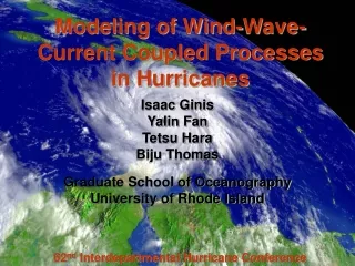
Modeling of boundary layer and air-sea interface processes in hurricanes. Isaac Ginis Graduate School of Oceanography University of Rhode Island. URI Collaborators : Tetsu Hara Yalin Fan Biju Thomas Richard Yablonsky Zhitao Yu Tom Tung.

E N D
Modeling of boundary layer and air-sea interface processes in hurricanes Isaac Ginis Graduate School of Oceanography University of Rhode Island URI Collaborators: Tetsu Hara Yalin Fan Biju Thomas Richard Yablonsky Zhitao Yu Tom Tung EMC/NCEP March 25, 2008
Hurricane Prediction Challenges • NWP models have demonstrably improved the forecasts of hurricane tracks over the last decades. • But to establish useful hurricane warning systems, it is necessary to accurately predict both storm track and intensity. • Whereas TC tracks are determined almost exclusively by their large-scale atmospheric environment, storm intensity is influenced to a greater degree by smaller-scale features in both the atmosphere and ocean. • The factors that control the intensity of TCs are still poorly understood, leading to limited reliability in forecasts of hurricane intensity evolution.
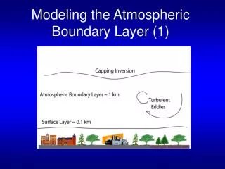
Hurricane Intensity Prediction Challenges • Variability in hurricane intensity originates from two sources: internal variability and environmental interactions. • There are three critical aspects of the environmental interactions in hurricanes: • the dynamical and microphysical processes near and at the sea surface that influence the turbulent exchange of heat and momentum between the ocean and atmosphere; • vertical and horizontal transport of momentum and heat in the atmospheric boundary layer; • the turbulent entrainment of relatively cold water from depths, which affects the sea surface temperature and thereby influences storm intensity.
NCEP Operational Hurricane Models HWRF GFDL Courtesy of R.Tuleya
Atmospheric BL-Wave-Current Interaction Processes Atmospheric Boundary Layer Sea state, Sea spray Atmosphere Current Surface waves Ocean Current Ocean currents
Drag Coefficient’s Sea State Dependence Storm Motion Vector Simulations with the URI wind-wave coupled model: Noel (2007), Helene and Florence (2006), Katrina, Rita, Emily, Dennis (2005), Ivan and Frances (2004), Isabel and Fabien (2003)
Effect of Waves on Momentum Flux into Ocean M - total momentum MF - total momentum flux Momentum Flux from Atmosphere ( ) Horizontal wave propagation ( ) Wave growth ( ) Momentum Flux into Currents ( ) Ocean Currents
Effect of Waves on Momentum Flux into Ocean • Idealized Hurricane experiments Holland Hurricane Wind Model Wind Field (m/s) 10 20 30 40 Input parameters: Maximum wind speed (MWS) Radius of MWS (RMW) Central & environmental sea-level pressure TSP = 5m/s Wind speed (m/s) Latitude 0 9 18 Longitude
Effect of Wind-wave-current Interaction W at 90 m Currents
Effect of Wind-Wave-Current Interaction on SST Cooling SST anomaly when as forcing (Control Exp.) SST anomaly in Fully Coupled Exp. — SST anomaly in Control Exp. (oC)
Idealized Hurricane-Wave-Ocean Experiments with GFDL Model Sea Surface Temperature Full Wind-Wave-Ocean Coupling No Wave Coupling
Idealized Hurricane-Wave-Ocean Experiments with GFDL Model
Idealized Hurricane-Wave-Ocean Experiments with GFDL Model Surface Wind Zo Cd
Boundary Layer Processes GPS dropsonde wind speed profiles in Hurricanes
Spectroradiometer (MODIS) image onboard NASA's Terra satellite on January 17, 2007 Boundary Layer Roll Vortices
Boundary Layer Roll Vortices in Huricanes Radarsat SAR:Hurricane Mitch Synthetic Apeture Radar (SAR) images of roll vortices observed in Hurricane Mitch, Bonnie, Daniel (1998) Katsaros et al. (2000) rolls
Synthetic Aperture Radar Image of Typhoon Fengshen (Jul. 24, 2002) (Morrison et al. 2005, JAS) Fine linear features between convective bands have a wavelength of 2–4 km
Schematic Structure of BL Rolls BL Rolls are spatially quasi-periodic with wavelengths that range from 100’s of meters to several km. In hurricanes, the typical vertical and cross-roll velocities are >~3 to 5 m/s and the along-mean-wind perturbation velocities are >~7 to 10 m/s.
Average momentum flux associated with the rolls vs the shear for Hurricanes Bonnie and Georges (Morrison et al. 2005, JAS) Gray – BL rolls Black – shear at 100m Based on Weather Surveillance Radar – 1988 Doppler (WSR-88D) data in Hurricane Bonnie and Georges
Roll vortices are commonly simulated numerically by 3-D large-eddy simulation (LES) models (Glendening, 1996) The background (large-scale) flow is often prescribed, such that only the effects of the background flow on rolls are considered (one-way interaction). Theoretical models of Foster (2005) and Nolan (2005) conclude that the hurricane BL is ideally suited for roll formation because of an instability associated with an inflection point that is characteristically present in the radial component of BL wind profiles. Theoretical and Numerical Studies of BL Rolls
3-D LES Simulation of Roll Vortices (Glendening 1996) (Vg=15 m/s) Plane View at Mid-BL
2-D LES Simulation of Roll Vortices(Ginis et al., 2004) 3.0 km, 61 levels 2-4 km 8.0 km, 40 m resolution Ginis, Khain, Morozovky, JAS, 2004
2-D LES Model: Mean Flow Equations , , Turbulent fluxes Convective fluxes Ginis et al. (2004)
2-D LES Model: Convective Equations , , , , . Ginis et al. (2004)
The mean flow equations are first calculated using a traditional first order turbulent closure scheme. All convective fluxes are assumed equal to zero. After an equilibrium state is achieved the convective equations are switched on which explicitly calculate the convective fluxes associated with large eddies. Experimental Design in Ginis et al. (2004)
Vertical Profiles of the Mean Flow Velocities Weak Wind Moderate Wind Strong Wind Ginis et al. (2004)
Sensible and Latent Heat fluxes at the Sea Surface Sensible Heat Flux Latent Heat Flux Dashed line - Moderate wind. Solid line – Strong wind Ginis et al. (2004)
2-D LES Model With Coriolis Effect Red:Geostrophic wind- coordinate system. y is the geostrophic wind direction. Black: Roll-coordinate system. x’ - cross-roll and y’ - along-roll Vg
Governing Equation for Mean Flow (2-D) Turbulent fluxes Convective fluxes
2-D LES Model Vertical Velocity Vg=15 m/s 3-D LES (Glendening 1996) Same Vg, N, f, zo Both show similar shape, size, and magnitude
2-D LES Model: Vertical Velocity Vg=15 m/s
Along-Roll Momentum Flux Heat Flux Cross-Roll Momentum Flux Total Fluxes (Convective+Turbulent) 2-D LES (Solid) vs. 3-D LES(Dashed) (Vg=15 m/s)
Strong Wind (Vg=45 m/s) Vertical velocity (T=20 hr) Cross-roll velocity (T=20 hr)
Our approach resemble a recently emerging approach of “super-parameterization” of the cloud physics processes in GCMs(Grabowski, 2001; Randall et al., 2003). Super-parameterization consists of a cloud resolving 2-D model embedded into a GCM, allowing explicit cloud simulations. Similarly, our proposed methodology can be called super-parameterization of the MBL which includes a roll vortices resolving 2-D LES model embedded into the 3-D equation system representing a TC model. Methodology for Explicit Representation of Roll Vortices and Sea spray Dynamics in Hurricane Models
Let’s assume that the TC model is formulated in the (X, Y, Z) coordinate system. The 2-D LES model is formulated in a local Cartesian coordinates (x, y, z) embedded in each column of the TC model so that y-axis is directed along the roll vortices, which are typically at a small angle to the mean flow within the MBL, x-axis is perpendicular to this direction Methodology for Explicit Representation of Roll Vortices and Sea spray Dynamics in Hurricane Models
Methodology for Explicit Representation of Roll Vortices and Sea spray Dynamics in Hurricane Models The decomposition into two subsystems for the mean flow variables and for the deviations is done by averaging of the 3-D system of equation system along the x-axis using the following averaging operator: L is the width of two or several rolls in x-direction. Each dependent variable is represented as a sum
Example for Continuity Equations An example for continuity equation written as div =0, where = is the velocity vector. In the derivation of it is assumed that
Example of Mean Flow Equations Momentum equation: Heat equation: Effect of turbulent mixing Effect of rolls Sea spray droplets number-size distribution:
Equations for Convective Motions (2D LES Model) • Obtained by subtracting the averaged equations from the original 3-D system of equations. • Taking into account that roll vortices are elongated in y-direction derivatives of convective variables along y-direction are much smaller compared to the derivatives of convective variables along x-direction. We may therefore neglect the derivatives of deviations along y-axis • As an example, the equation for deviations of potential temperature: