Download
1 / 14
140 likes | 273 Views
Discover Mozambique, a vibrant nation located in Southeast Africa, with a rich tapestry of culture and history. The country's flag symbolizes its journey to independence, representing peace, land, and the struggles of its people. Home to 19.7 million inhabitants, Mozambique boasts diverse ethnic groups and languages, primarily Portuguese. Major tourist attractions include Maputo's Elephant Reserve and the stunning Bazaruto Archipelago. Despite historical challenges, Mozambique is rich in natural resources and cultural heritage, making it a unique travel destination.

E N D
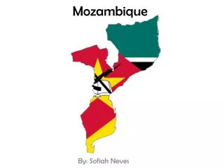
Mozambique BY : Erick Dejesus
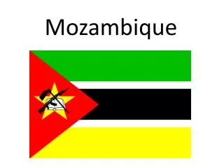
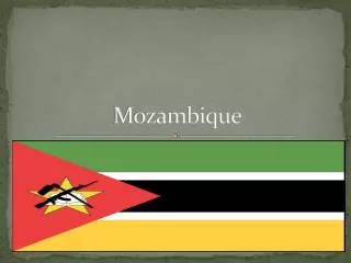
The Flag of Mozambique • The white lines represents peace • The black color represents the African continent • Green represents the land. • The yellow represents the mineral wealth of the nations. • The red represents the struggle for independence. • The book represents the education of Mozambique. • The hoe represents their agriculture. • The rifle represents the determination to defend it’s freedom.
Geography • Full Name: Republic of Mozambique • Capital: Maputo(formerly known as Louren Marques) • Area in square Miles: 801,590 sq. mi. Slightly less than twice the size of California. • Climate: Tropical and Sub Tropical. • Seasons: Wet Season:October to March Dry Season: April to September. • Geographic Features:Monte Binga and Lake Malawi. • Location: South East of Africa. Borders Indian Ocean Borders Swaziland, Zambia, Malawi, Zimbabwe, and South Africa.
People • Population: 19.7 million • Major Languages: Portuguese • Religion: Catholic23.8%, Muslim 17.8%, other 17.8%, none 23.1% • Life Expectancy: 40 years • Annual Income per capita(person): 29,050 MZN = 1,070 USD • Health-Infant Mortality Rate:129/1000 • Unemployment Rate: 21% • Ethnic Groups:Makua, Tsonga, Makonde, Shangaan, Shona, Sena, Ndau, and Chopi
History • 1-1000: Bantu-speaking people settle in Mozambique. The Bantu were farmers and iron workers. • 1498: Portuguese explorers arrive at Mozambique. • 1752: Mozambique becomes a Portuguese colony. • 1907: Maputo becomes the capital of Mozambique. • 1962-1974: Rebels fight for independence from Portugal. Their fight becomes more organized in the 1960’s because they formed the Front for the Liberation of Mozambique, which is now shortened to FRELIMO. • 1975: Floods and droughts that has lasted 4 years has made the economy to suffer because the farmers can’t grow crops.
More History • 1977:Rebels and the government are in a civil war. • 1992: Civil war ends and government and rebels sign a peace treaty. • 1994: Mozambique holds its first multiparty election for president. Joaquim Chissano wins election for president. • 1990-1995: More then 1.7 million Mozambicans return to Mozambique because they fled the country during the civil war to be safe. • 2000-2001: Floods still damage Mozambique which slows down the government’s attempt to rebuild the economy after the civil war. • 2004: President Joaquim retires and Armando Guebuza is now the new president of Mozambique
Government • Multi-party Democracy • Independence: June 25 1975 • Constitution: November 1990 • Branches: • Executive- resident, Council of Ministers Legislative- National Assembly, municipal assemblies Judicial- Supreme court, provincial district, municipal courts.
Economy • After 1975 when Mozambique gained it’s independence its was one of the worlds poorest countries. • Natural Resources: Hydro electric power, coal, natural gas, titanium ore, tantalite, graphite, and iron ore. • Agriculture: Exports- cotton, cashew nuts, sugarcane, tea, cassava, corn, coconut, sisal, citrus, tropical fruits, potatoes, sunflowers, beef, and poultry. • Main exports: Aluminum, cashews, prawns, cotton. sugar, citrus, timber, bulk electricity, and natural gas.
Customs and Traditions • Mozambique’s culture is a blend of Portuguese and eastern influences. The Chopi located on the south-central coast are known for their complex musical arrangements and dance. The makonde are located in the north and are known for their ebony sculptures and masks.
Major Tourist Attractions • Major attractions in Mozambique are: • Beira • Nampula • Maputo • Bazaruto Archipelago
Maputo: Maputo is the capital of Mozambique. It has an Elephant Reserve, and the Mueseum of Revolution that’s about how Mozambique won their independence from Portugal. The central Railway Station which was made by Gustave in 1910 which is considered to be the most beautiful in the world because it has marble pillars, and a large central dome.
Beira: It is the second biggest city in Mozambique. It’s attractions is the cathedral, lighthouse, Macuti Beach, and the grand hotel Beira. Nampula: Nampula is the capital city of Nampula Province. It’s tourist attractions is the cathedral and it has the National Ethnographic Museum which has mask, musical instuments and other historical artifacts.
Bibliography • Mozambique Flag:"Flag of Mozambique." image. CIA Central Intelligence Agency Factbook.13 Apr. 2009 <https://www.cia.gov/library/publications/the-world-factbook/flags/mz-flag.html>. • "Mozambique Map." image. U.S. Department of State.14 Apr. 2009 <http://www.state.gov/p/af/ci/mz/>. • "Mozambique sightseeing map." image. Time for kids.14 Apr. 2009 <http://www.timeforkids.com/TFK/kids/hh/goplaces/article/0,28376,1173008,00.html>. • "Timbila." photograph. Viajando con la Luna.14 Apr. 2009 <http://viajandoconlaluna.blogspot.com/2008_03_01_archive.html>. • "Cathedral in Nampula, Mozambique." photograph. Wikipedia.14 Apr. 2009 <http://en.wikipedia.org/wiki/File:Nampulacathedral.JPG>. • "Beira, Mozambique town center." photograph. Wikipedia.14 Apr. 2009 <http://en.wikipedia.org/wiki/File:DF-SD-01-01576.jpg>. • "bazaruto archipelago." photograph. African Bushcamp Safaris.14 Apr. 2009 <http://www.bushcamps.com/destinations/southern_africa/Mozambique/attractions_sub-1-attractionsId-2-30>. • "xylophone timbila." photograph. umich.14 Apr. 2009 <http://www.si.umich.edu/CHICO/instrument/pages/xylo_gnrl.html>. • "Makonde men." photograph. The Robert Goldwater Library online resource.14 Apr. 2009 <http://newsgrist.typepad.com/robertgoldwaterlibrary/2007/11/a-century-of-ma.html>. • "coat of arms." image. Mozambique.14 Apr. 2009 <http://www.unitedcaribbean.com/mozambique.html>. • http://www.flickr.com/photos/alastairhumphreys/2982094444/ • Women removing Chaff." photograph. Flickr.14 Apr. 2009 <http://www.flickr.com/photos/aquistbe/19026840/>.
Bibliography • "Maputo." photograph. Flickr.14 Apr. 2009 <http://www.flickr.com/photos/julianoipolito/72012516/>. • "President of Mozambique." photograph. NySE Euronext.14 Apr. 2009 <http://www.flickr.com/photos/julianoipolito/72012516/>. • "man with fish." photograph. Painet.14 Apr. 2009 <http://www.painetworks.com/pagesrf/hq/hq1438.html>. • "Basket Fishing." photograph. Flickr.14 Apr. 2009 <http://www.flickr.com/photos/alastairhumphreys/2981237971/>. • "Mozambique Makonde Mask." photograph. Flickr.24 Apr. 2009 <http://www.flickr.com/photos/32357038@N08/3203717137/>. • "central railway station." photograph. wordtravels.20 Apr. <http://www.wordtravels.com/Cities/Mozambique/Maputo/Attractions>.