Download
1 / 27
340 likes | 778 Views
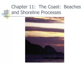
Chapter 11: The Coast: Beaches and Shoreline Processes. Coastal region. Shore between low tide and highest elevation affected by storm waves Coast from shore to farthest inland ocean features. Fig. 11-1. Beach. Actively changing Shore: backshore, foreshore, nearshore, offshore

E N D
Coastal region • Shore between low tide and highest elevation affected by storm waves • Coast from shore to farthest inland ocean features Fig. 11-1
Beach • Actively changing • Shore: backshore, foreshore, nearshore, offshore • Berm, beach face, longshore bar, longshore trough Fig. 11-1
Beach composition and shape • Locally available material • Coarser sediment • Beach steeper • Finer sediment • Beach more gentle
Sand movement • Swash and backwash • Sediments moved up and down beach face • Smaller, low energy waves sand moved up beach face • Summertime beach • Larger, high energy waves sand moved off shore • Wintertime beach
Sand movement • Longshore current • Longshore drift or transport • Parallel to shore • Increasing strength • More wave energy • Higher wave frequency • Steeper beach • Greater angle
Longshore current main way sediments moved along coasts • Southward along both U.S. coasts most of the time
Erosional-type shore • Headlands eroded • Sea arches • Sea stacks • Wave-cut cliffs • Sea caves • Tectonically active coasts • Example Pacific coast U.S.
Depositional-type shores • Sediments re-distributed by ocean processes • Typical in tectonically passive areas
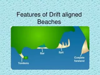
Depositional features • Spit • Tombolo • Bay barrier or baymouth bar Fig. 11-7
Barrier islands • Ocean beach • Dune • Barrier flat • High salt marsh • Low salt marsh • Lagoon • Rising sea level pushes barrier island landward Fig. 11-10
Deltas FIG. 11.11b • Rivers deposit sediment at coast • If more fluvial influence than ocean influence • Bird’s foot delta • If more ocean influence than river influence • Arcuate delta
Shepard classification of coasts • Primary • Geologically youthful • Controlled by non-marine processes • Examples • “Drowned” river or glacial valleys • Volcanic coasts • Coasts shaped by recent tectonic movements
Secondary coasts • Geologically mature • Controlled by marine processes • Tectonically passive • Examples • Straightened coasts • Coral reefs • Marsh grass Fig. 11-13f
Emergent coasts • Uplift or sea level drops • Once marine is now land • Marine terraces • Stranded beach deposits
Submergent coasts • Subsidence or sea level rises • Once land (or shallower) is now underwater (or deeper) • Drowned beach deposits • Drowned river/glacial valleys • Submerged dunes
Tectonic and isostatic changes • Tectonic uplift and subsidence • Larger scale: major parts of continents • Smaller scale: local deformation • Isostatic adjustments to loading • Sediments or ice • Regional and local effects • Affect sea level
Eustatic changes in sea level • Global • Changes in spreading rates of ocean floor • Changes in ice volumes • Changes in ocean temperature • Global warming • Sea level rises • Ice melts, ocean warmer Fig. 11-15
Atlantic coast of U.S. • Mainly submergent • Barrier islands • Glaciers shaped some shorelines • Eroding coasts • Subsidence in most areas
Gulf coast of U.S. • Mainly submergent • Barrier islands • Mississippi delta • High rates of erosion • Tectonic subsidence
Pacific coast of U.S. • Mainly emergent • Less erosion • Mainly rocky shoreline • Dams on rivers beach starvation • Tectonically active
U.S. coastal erosion, deposition Fig. 11-17
Hard stabilization • Groin and groin field • Perpendicular to shore • Traps sand between groins • Interrupts longshore current • Jetty similar • Built to protect harbor entrance • Sand on upcurrent side
Breakwater • Parallel to shore • Offshore • Deposition behind breakwater
Seawall • Built on beach • Parallel to beach • Erosion enhanced seaward of wall • Seawall destroyed • Beach narrowed Fig. 11-25
Alternatives to hard stabilization • Limit construction near shore • Relocate businesses/homes destroyed by wave erosion
End of Chapter 11: The Coast: Beaches and Shoreline Processes