Download
1 / 97
1.03k likes | 1.44k Views
Prof. S. N. Panda Head, School of Water Resources. Groundwater Modelling of Ganga Basin – Opportunities and Challenges. Physiography and groundwater flow of Ganga basin. (Source: Ministry of Environment and Forests, Government of India).

E N D
Prof. S. N. PandaHead, School of Water Resources Groundwater Modelling of Ganga Basin – Opportunities and Challenges
Physiography and groundwater flow of Ganga basin (Source: Ministry of Environment and Forests, Government of India)
Annual groundwater draft in comparison with net annual availability in Ganga basin (Source: Ministry of Environment and Forests, Government of India)
Annual replenishable groundwater in comparison with annual draft in Ganga basin (Source: Ministry of Environment and Forests, Government of India)
Schematic illustration for evaluating stream-aquifer interaction Reach inflow Evaporation Change in storage Groundwater inflow Inflow or leakage to/from groundwater Stream inflow Rainfall Reach Outflow Stream Reach Recharge to groundwater Evapotranspiration Groundwater outflow Stream outflow
Problems with groundwater in the Ganga Basin • Imbalance in groundwater draft • Waterlogging and salinity in canal commands • Groundwater pollution
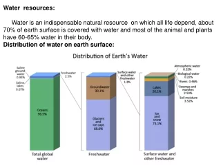
Types of Terrestrial Water Surface Water Soil Moisture Ground water
Movement of water through the hydrologic cycle (Source: usgs.gov)
Effluent and influent streams Gaining stream Losing stream with shallow watertable Base flow Losing stream with deep watertable
Water Balance Concept The basic concept of groundwater balance is: Input to the system ‑ outflow from the system = change in storage of the system (over a period of time)
Flow components for assessing groundwater balance ET Overland Flow Pr Ir Boundary Seepage Pumping well Per Cap Boundary Watertable Qper Sgrw Qdr Qlsi Qlso Qup Qdo Clay
Groundwater Balance Equation Considering the various inflow and outflow components in a given study area, the groundwater balance equation can be written as: Rr + Rc + Ri + Rt + Si + Ig = Et + Tp + Se + Og + S where, Rr = recharge from rainfall Rc = recharge from canal seepage Ri = recharge from field irrigation Rt = recharge from tanks Si = influent seepage from rivers Ig = inflow from other basins Et = evapotranspiration from groundwater Tp = draft from groundwater Se = effluent seepage to rivers Og = outflow to other basins; and S = change in groundwater storage
Groundwater Survey and Investigation Water table contour map showing a local mound and depression in water table and direction of groundwater flow Water table contour map
Flow net Flow net technique for estimation of subsurface horizontal flow
Components of a Mathematical Model • Governing Equation • (Darcy’s law + water balance equation) with head (h) as the dependent variable • Boundary Conditions • Initial conditions (for transient problems)
General governing equation for steady-state, heterogeneous, anisotropic conditions, without a source/sink term with a source/sink term
Allows for multiple chemical species Dispersion Chemical Reactions Advection Source/sink term Change in concentration with time • is porosity D is dispersion coefficient v is velocity
Model Grids Finite Difference Grid Finite Element Grid
Conceptual Model Update Model Mathematical Model Unsatisfactory Results Modelling Process Computation Poor Fit Compare Model and Field Calibrate Model Satisfactory Results Conclude study (Decisions & Recommendations)
Opportunities and Challenges in the Ganga Basin • Wide variation in climate from semi-arid to sub-humid/sub-tropical regions • Large-scale spatial variation in • Soil texture and land-use • Type of aquifers and its properties • Spatio-temporal variation in - meteorological parameters associated with uncertainties - groundwater recharge and discharge components • Groundwater level monitoring is not being done regularly and intensively • Setting up/optimising monitoring networks and setting up groundwater protection zones • Groundwater resources too need to be planned and managed for maximum basin-level efficiency.
Diversified geological climatological and topographic set-up, giving rise to divergent ground water situations • Excessive use of our rivers, are causing downstream problems, of water quality and ecological stress. • Climate change impacts directly on the availability of water resources both in space and time. • The precarious balance between growing demands and supplies brings forth the importance of maintaining quality of both surface and ground water.
Application of existing groundwater models include water balance (in terms ofwater quantity) • gaining knowledge about the quantitative aspects of the unsaturated zone • simulating of water flow and chemical migration in the saturated zone including river-groundwater relations • assessing the impact of changes of the groundwater regime on the environment
State-wise distribution of the drainage area of Ganga river (Source: Status paper on river Ganga, NRCD, MoEF, 2009)
Soil types in Ganga basin (Source: Central Pollution Control Board, National River Conservation Directorate (MoEF) (2009))
Data requirement for groundwater balance study over a given time period: • Precipitation • River • Canal • Tank • Water table • Groundwater draft • Aquifer parameters • Land use and cropping patterns
Management of a groundwater system, means making such decisions as: • The total volume that may be withdrawn annually from the aquifer. • The location of pumping and artificial recharge wells, and their rates. • Decisions related to groundwater quality. • Groundwater contamination by: • Hazardous industrial wastes • Leachate from landfills • Agricultural activities such as the use of fertilizers and pesticides
Groundwater Modelling • The only effective way to test effects of groundwater management strategies • Conceptual model Steady state model Transient model • Processes Groundwater flow (calculate both heads and flow) Solute transport – requires information on flow (calculate concentrations)
Model Design • Conceptual Model • Selection of Computer Code • Model Geometry • Grid • Boundary array • Model Parameters • Boundary Conditions • Initial Conditions • Stresses
Conceptual Model Update Model Mathematical Model Unsatisfactory Results Modelling Process Computation Poor Fit Compare Model and Field Calibrate Model Satisfactory Results Conclude study (Decisions & Recommendations)
General governing equation for transient, heterogeneous, and anisotropic conditions Kx, Ky, Kz are components of the hydraulic conductivity Specific Storage Ss = V / (x y z h)
Types of Solutions of Mathematical Models • Analytical Solutions: h= f(x, y, z, t) • Numerical Solutions • Finite difference methods • Finite element methods
Model Design • Conceptual Model • Selection of Computer Code • Model Geometry • Grid • Boundary array • Model Parameters • Boundary Conditions • Initial Conditions • Stresses
Suitability of groundwater in increasing dry season productivity in the coastal region of the Ganga basin • How the recharge mechanisms can be used to reduce salinity. • Climate change impact on groundwater.
Management of Excess Rainwater • Mismatch between water supply and demand • Possible solutions • Rainwater conservation and recycling • Multiple use of harvested water • Managed aquifer recharge • Management of stagnant water in lowland areas
Rainwater Conservation a. Storage of rainwater on surface reservoir b. Recharge to ground water • Pits • Trenches • Dug wells • Hand pumps • Recharge wells • Recharge shafts • Lateral shafts with bore wells • Spreading techniques
Methods of Rainwater Storage • Infiltration • Injection
Benefits • Ideal solution to water problems in water stress areas • Capture and storage of water in monsoon when rainwater is abundant • More water will be available for summer use • Rise in groundwater level - Improves declining aquifers • May increase base flow to streams • Mitigates the effects of drought • Reduces the runoff which chokes the storm water drains • Flooding of roads and low land areas are reduced • Quality of water improves • Soil erosion will be reduced • Saving of energy per well for lifting of ground water – 1 m rise in water level saves about 0.40 KWH of electricity
What is Managed Aquifer Recharge (MAR)? • Managed Aquifer Recharge is: • The infiltration or injection of water into an aquifer • Water can be withdrawn at a later date but also left in the aquifer (e.g. to benefit the environment) Why Consider MAR? • Allows storage of water in wet seasons • Improvement in groundwater quality • Allows increased use of groundwater from other parts of the aquifer systems • To stop seawater intrusion in coastal areas • To maintain or increase available water supplies for use in agriculture, drinking water supply, and industry