Download
1 / 17
731 likes | 8.14k Views
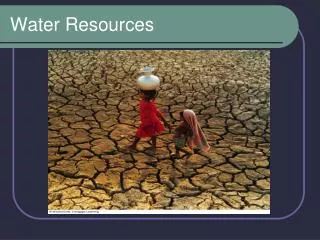
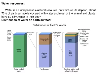
Water resources: Water is an indispensable natural resource on which all life depend, about 70% of earth surface is covered with water and most of the animal and plants have 60-65% water in their body. Distribution of water on earth surface:. Water: a unique resource

E N D
Water resources: Water is an indispensable natural resource on which all life depend, about 70% of earth surface is covered with water and most of the animal and plants have 60-65% water in their body. Distribution of water on earth surface:
Water: a unique resource • Water is characterize by certain features which make it a marvelous resource: • exist as a liquid over a wide range of temperature i.e. from 0°C to 100°C. • High specific heat, due to which it warms up and cool down slowly without causing shocks of temperature jerks to the aquatic life. • Water is called the "universal solvent" because it dissolves more substances than any other liquid. It can serve as a very good carrier of nutrient which are essential for the aquatic biota. • Due to high surface tension and cohesion , it has the capillary effect which help it in the movement through great heights through the trunk of the tree. • As it freezes, its density become lower. Being lighter ice keeps floating , whereas the bottom water remains at a higher temperature and therefore, can sustain aquatic organism even in extreme cold.
Hydrological Cycle: Earth's water is always in movement, and the natural water cycle, also known as the hydrologic cycle, describes the continuous movement of water on, above, and below the surface of the Earth.
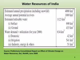
Water Uses: Water is used for drinking, irrigation, transportation, washing and waste disposal and as coolant for thermal power plant and other industries. India water use World water use
Type of water resource: Ground water: Groundwater is the major source of fresh water and usually considered as more clean than the surface water however in recent decade fertilizer and pesticide originating from the agricultural lands and heavy metal from landfill sites are major ground water pollutant. Ground water are mainly withdraw from aquifers. Aquifers: derive from Latin words, "Aqua" (water), and "fer" (to carry). An aquifer is a sub-surface geologic formations (solid rock and/or unconsolidated sediments) that contains ground water in sufficient quantities to be used, or have the potential to be used, for drinking water supply or for commercial, industrial or agricultural purposes. Three type of aquifers are their: Unconfined aquifer: Overlaid by permeable earth materials and they can be recharged by water seeping down from above in the form of rainfall or snow melt. Confined aquifer: are confined between two impermeable layers of rock or sediment and are recharged only in the those areas where the aquifer intersect the land surface. Perched aquifer: water get trapped between impermeable structure, no recharge takes place in these aquifer.
Effects of overexploitation of Ground water: Subsidence: When the rate of withdrawal is more than its recharge rate, the sediment in the aquifer get compacted and results into the ground subsidence. Examples: The north china plains, Farrukhabad district , U.P. Lowering of water table: Lowering of water table in semi-arid and arid region due to overexploitation and lower recharge rate is very common phenomenon. Example: Delhi and Punjab region showed lowering of ground water level. Sea water intrusion: especially occurs in costal areas, where salt water front move further in land due to excess pumping of ground water. Costal area of Gujarat and Tamil Nadu faces this problem. Low supply to river and wetlands: Ground water is important source of water to the perennial rivers especially in the non-monsoon season, overexploitation results into lowering of water table thus reducing the supply of water to river or wetland areas. Water logging and salinity: common problem in intensive agricultural areas, where farmer applied excess water on the land results into raising of water table and subsequently water logging and increase salinity. Occurs in Punjab regions.
Surface water: The part of precipitation which does not percolate down or get evaporated to atmosphere forms the surface water mainly in the form of stream, lake, ponds, wetlands or artificial reservoir. It serves multiple purpose such as provide water for domestic, industrial and irrigation purpose, navigation and electricity generation, provide habitat for aquatic species. Availability of surface water resources depends upon two precipitation phenomenon: Floods: Most of the rainfall is concentrated into 4 months of monsoon season characterize by heavy rainfall resulting into increased river discharge sometime exceeding the capacity of river channel to hold such amount of water which cause the flooding of floodplain and nearby areas. As per the Geological Survey of India (GSI), the major flood prone areas of India cover almost 12.5% area of the country. In India major flood prone area are categories into: Ganga Basin: West Bengal, Bihar and Uttar Pradesh are mainly prone to flood every year. Main river basins are: Ganga, Rapti, Gandak, Ghagra, Mahananda, Bhagirathi, Damodar, Bagmati, Gandak, Kamla etc. Brahmaputra and Barak Basins: West Bengal, Assam and Sikkim. Main river basins are Brahmaputra, Barak, Jaldakha, Teesta and Torsa river etc.
Central India and Deccan Rivers Basin: Andhra Pradesh, Odisha and Tamil Nadu. Main river basins are: Narmada, Godavari, Tapi, Krishna and Mahanadi. Flood Prevention • Non Structural Measures: • Flood Plain Zoning: • Flood Forecasting and warning • Structural Measures: • 1) Construction of Embankments and levees. • Watershed Management • Artificial reservoir through dam construction
Droughts: • Drought may be defined as an extended period – a season, a year or more – of deficient rainfall relative to the statistical multi-year average for a region. • Type of Drought: • Metrological drought: According to the India Meteorological Department (IMD), meteorological drought occurs when the seasonal rainfall received over an area is less than 75% of its long-term average value. • Agricultural drought: insufficient soil moisture to meet the needs of a particular crop at a particular point in time. • Hydrological drought: deficiency in surface and sub-surface water supply. It is measured as stream flows and also as lake, reservoir and groundwater levels. • Causes of Drought: • 1) Erratic rainfall during monsoon: The southwest monsoon denotes the rainfall • received between the months of June and September and accounts for around 74% • of the country's rainfall. • 2) Reckless over-exploitation of surface and groundwater: for agricultural areas results into drought like situation. Selection of high water requiring plants such as sugarcane also resulted into drought into many part of Maharashtra.
3) Deforestation: Deforestation leads to drought as forest protect the watershed thus ensures greater availability of water, less soil erosion, more rainfall, flood and landslide control, etc. • 4) Climate change: Climate change also aggravate the problem of drought due to increases uncertainty in the monsoon pattern due to frequent occurrence of El Nino events. • Consequences of Drought: • Impact on crop production: Drought has detrimental effect on the crop production. Food grain production dipped by 29 million tonnes to 183 million tonnes in 2002.(212 million tonnes in 2001). • Impact on water resources: In nine of the 10 drought-affected states, over 50% of wells experienced a drop in groundwater levels. It also affects the water availability in the surface reservoir for useful purpose. • Impact on cattle and fodder: Water and fodder shortages during a drought situation cause considerable stress to small and marginal farmers, as they own a bulk of the bovine population. • Impact on the power situation: Hydroelectric power stations contribute 25% of the total power generated in the country (2001), a fall from 41% in 1961. Any stress on • the water situation, as in a drought, can have serious consequences, especially in • states already battling a power deficiency.
Mitigation measures for droughts: • 1) Development of early warning and expert systems: By using modeling to predict monsoon behavior and also to measure available water resource in a particular area. • 2) Integrated watershed management rainwater harvesting: for proper management of water resource and to increase available pool of water for useful purpose. • 3) Soil and crop management approaches: proper soil conservation methods to stop soil erosion and nutrient management with suitable agricultural and irrigational practice such as crop rotation, drip irrigation methods. • Some examples: • Ralegan Siddhi: villagers built check dams and tanks. To conserve soil they planted trees. The result: from 80 acres of irrigated area two decades ago, Ralegan Siddhi has a massive area of 1300 acres under irrigation. • 2) Tarun Bharat Sangh: The work of Tarun Bharat Sangh, and it's founder Rajendra Singh in the districts of Rajasthan can easily be over-simplified as water-shed management whereas, it is in fact a revolution in regenerating life and society in denuded and deserted lands.
Water resource dispute: Water resource especially surface water sources such as rivers often cross more than one nations or states giving rise to dispute related to its distribution. Some of the major disputes are: • Water conflict in the Middle east: Mainly related to the distribution of three major river basins, name Jordan, Tigris-Euphrates and Nile between different middle east countries. • The Indus water treaty: In 1960, sharing of water from Indus river basin between India and Pakistan, where Indus, the Jhelum and the Chenab were allocated to Pakistan and Satluj, the Ravi and the Beas were allocated to India. • India-Bangladesh water disputes: Construction of Farakka Barrage in 1974 over Bhagirathi river causes dispute between India and Bangladesh over sharing of Ganga water. • Cauvery water dispute: dispute between state of Karnataka and Tamil Nadu over sharing of Cauvery water resulted into formation of Cauvery water Dispute tribunal in 1990. • The Satluj-Yamuna Link canal Dispute: Between Punjab and Haryana for sharing the Ravi-Beas waters, and case is now in Supreme court. • Mullaperiyar Dam: recent controversies between state of Kerala and Tamil Nadu over Mullaperiyar Dam over Periyar river.
Traditional water Management System: • Neerkatti: In South India, they manage the water system my using tradition tank system. They are the people responsible for the distribution of water to the agricultural land. • Havaldars or Jaghyas: In Maharashtra, they manage and resolve involving conflicts by overseeing the water channels from main canal to the distributory canal. • Churpan: water manager in the Ladakh region have the power to allocate available water resources. • irrigation of rice terraces with bamboo pipes: water is transported through an intricate system of Bamboo pipes to agriculture fields in the Arunachal Pradesh. • DAMS (Benefits and Problem): • Described as 'New Temple of Resurgent India' by Jawaharlal Nehru Dams are usually considered to play a key role in development process due to their multiple uses, however Dams are also associated with the multiple environmental and social problems:
Benefits of Big Dams: • Increase availability of water for domestic and irrigational purpose especially in the regions of water deficits. Example: Irrigated land increased from 22.6 million hectares (ha) in 1951 to about 89.6 million ha by 1997, marking a fourfold growth over a period of 50 years. • Electricity generation: Hydroelectricity account for 25% of total electricity generated in India. • Dams store water during peak discharge period and release it during the low flow period thereby mitigating the risk of floods and drought. • Construction of dams facilitate in-land navigation by maintaining river flow. • Employment generation for the local population during the construction and maintenance of dam. • Site for recreational activity and tourist spot for examples Bhakra Dam, Tehri Dams are major sites for tourist attraction.
Problem associated with Dams: 1) Biodiversity loss: submergence of large areas of land due to construction of reservoir leads to loss of forest, flora and fauna of the area. 2) Displacement of tribal and local area: Dams construction results into displacement of local population residing in that area, and resettlement of these displaced people are one of the major problem. In India approx. 16 to 38 million people displaced due to construction of large Dams. 3) Fragmentation and physical transformation of river system. 4) Change in the migratory route of Fish thereby reducing the total fish population in the river system. 5) Capturing of the silt and sediment on the upstream side of dams results into fertility loss in the flood plain in the down stream areas. Example: Aswan dam on Nile river. 6) Increase risk of seismicity associated with the dam construction. Example: Koyna Dam in Mahrastra. 7) Risk of flash flood due to bursting or leakage of dams. Example Panshet dam burst near Puna.
Case studies: 1) Sardar Sarovar Project: This dam is constructed on Narmada River, in Gujarat.