Download
1 / 6
60 likes | 179 Views
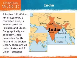
India covers an extensive area of 3,287,263 square kilometers, making it the 7th largest country globally. With approximately 7,000 kilometers of coastline, it boasts diverse geographical features, including the Himalayan Mountains and the Ganges River, its longest river. The Ganges is also the most heavily populated basin in the world, supporting millions who rely on it for daily activities such as bathing and fishing. The country has 47.87% of its land classified as arable. India is bordered by the Arabian Sea, the Bay of Bengal, and the Indian Ocean.

E N D
India By Pat and Connor
Size and land usage • Area: 3,287,263 sq. kilometers • 7th largest country in the world • About 7,000 km of coastline • Arable land 47.87%
Major geographic features • India is surrounded by three main bodies of water the Arabian Sea, the Bay of Bengal, and the Indian Ocean. • Himalayan Mountains • The Ganges River is the longest river in India • The Thar desert in the West • The Deccan Plateau
Impact of Ganges River • Most heavily populated basin in the world • People live along its banks for daily needs such as bathing and fishing • Important to the Hindus • Most sacred river