Download
1 / 44
440 likes | 464 Views
Learn about NH's program expanding broadband access through mapping, grants, and partnerships to boost economic benefits and job opportunities. Explore funding opportunities and technical assistance available for infrastructure projects and broadband adoption initiatives.

E N D
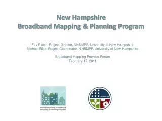
New HampshireBroadband Mapping & Planning Program Fay Rubin, Project Director, NHBMPP, University of New Hampshire Michael Blair, Project Coordinator, NHBMPP, University of New Hampshire Broadband Mapping Provider Forum February 17, 2011
Broadband Funding under the American Recovery and Reinvestment Act of 2009 The Recovery Act appropriated $7.2 billion and directed the Department of Agriculture's Rural Utilities Service (RUS) and the Department of Commerce's National Telecommunications and Information Administration (NTIA) to expand broadband access to unserved and underserved communities across the U.S. in order to increase jobs, spur investments in technology and infrastructure, and provide long-term economic benefits. The result: • RUS Broadband Initiatives Program (BIP) – loans/grants for broadband infrastructure projects in rural areas; • NTIA Broadband Technology Opportunities Program (BTOP) – grants to fund broadband infrastructure, public computer centers and sustainable broadband adoption projects.
Broadband Technology Opportunities Program (BTOP) “The U.S. Congress has appropriated $4.7 billion to establish Broadband Technology Opportunities Program for awards to eligible entities to develop and expand broadband services to rural and underserved areas and improve access to broadband by public safety agencies …” • $ 3.9 billion - for broadband expansion • $250 million – innovative programs that encourage sustainable adoption of broadband services • $200 million – build capacity at public computing centers, including community colleges and public libraries • $10 million - transfer to the Office of Inspector General for the purposes of BTOP audits and oversight • $350 million - development and maintenance of statewide broadband inventory maps. (Grants to all 50 states, 5 territories, and District of Columbia. Total allocation $103 million round 1; $190 allocated in supplemental award.)
New Hampshire Broadband Mapping & Planning Program Partners • University of New Hampshire: • GRANIT/Complex Systems Research Center • Computing & Information Services • Cooperative Extension • Regional Planning Commissions: • Central New Hampshire Regional Planning Commission • Lakes Region Planning Commission • Nashua Regional Planning Commission • North Country Council • Rockingham Planning Commission • Southern NH Regional Planning Commission • Southwest Region Planning Commission • Strafford Regional Planning Commission • Upper Valley Lake Sunapee Regional Planning Commission • NH Department of Resources and Economic Development • NH Office of Energy and Planning • Community Development Finance Authority • Granite State Distance Learning Network • * Partners in broadband mapping component
NHBMPP Program Components Round 1 ($1.7 million) Mapping (Jan 2010 – Dec 2011): $1.2 million Identify, inventory, map, and verify areas served by current broadband infrastructure – by type of technology and speed of transmission Identify areas unserved or underserved Develop/maintain Community Anchor Institutions data set Planning (Jan 2011 – Dec 2014): $490K Supplemental ($4.4 million) Mapping (Jan 2011 – Dec 2014): $1.5 million Rural Addressing (Jan 2011 – Dec 2013): $410K Nonmapping (Jan 2011 – Dec 2014): $2.45 million Technical Assistance to local boards through web resources (OEP & UNH Cooperative Extension - $.95 m) Statewide Broadband Capacity Building (DRED, CDFA & UNH - $.8 m) Local / Regional Broadband Planning (RPCs, OEP - $.7 m)
Mapping Component Overview Acquire/Process Service Provider Data Obtain service coverage data from providers: broadband availability, technology, speed, infrastructure, and for wireless – spectrum used Inventory Community Anchor Institutions/State Agencies Map location of each CAI, and conduct telephone survey to collect broadband access information Conduct Analysis Compile the provider information into statewide maps displaying areas served by type of technology and speed tier Share and Display Information Develop consumer reporting and mapping website(s): www.iwantbroadbandnh.org
Key Definitions Broadband - Advertised speeds of at least 768 kbps downstream and 200 kbps upstream Unserved area – One or more contiguous census blocks where >= 90% of households (HH’s) lack access to facilities-based terrestrial BB service, fixed or mobile (at minimum speed noted above) Underserved area - One or more contiguous census blocks where one of the following factors is present: • <= 50% of HH have access to facilities-based terrestrial BB service (at minimum speed noted above) • no fixed or mobile BB provider advertises transmission speeds of at least three mbps; or • the rate of BB subscribership for the area is <= 40% of HHs.
Census Geography • Block: • Smallest unit of geography for data collection • Bounded by visible features • Tract: • Subdivision of county • Optimum size of 4,000 people, but can range from 1,500 – 8,000 • Initially, goal is for homogeneity w/r to population characteristics Source: www.census.gov/www.cengeoga.pdf
Census Geography • Block: • Smallest unit of geography for data collection • Bounded by visible features • Tract: • Subdivision of county • Optimum size of 4,000 people, but can range from 1,500 – 8,000 • Initially, goal is for homogeneity w/r to population characteristics
Source Data Sets Service provider data GRANIT base map layers Census derivatives – roads, census blocks Aerial photography Parcel data Tabular data from assorted sources (DHHS master list of health care facilities) Vegetation Topography
Progress to Date Development of guidance/protocols Identification of active service providers Execution of NDAs with providers Acquisition and processing of provider data sets – 2nd round submitted September, 2010 Development of statewide coverage maps by download/upload speed, type of technology Development of preliminary CAI data set (3500+ records) Web site development (iwantbroadbandnh.org) Hosted community broadband forums (15 hosted in fall of 2010) Using Cellular Expert software (www.cellular-expert.com) to predict signal strength. Note: Data generated for display purposes only, and does not represent the actual coverage area of any service provider.
Signal Propagation Modeling Using Cellular Expert software (www.cellular-expert.com) to predict signal strength. Note: This data was generated for display purposes only, and does not represent the actual coverage area of any service provider.
BroadbandAvailabilityinNew HampshireBased on data reported as of:September, 2010
BroadbandAvailabilityinNew HampshireBased on data reported as of:September, 2010
BroadbandAvailabilityinNew HampshireBased on data reported as of:September, 2010
BroadbandAvailabilityinNew HampshireBased on data reported as of:September, 2010
BroadbandAvailabilityinNew HampshireBased on data reported as of:September, 2010
BroadbandAvailabilityinNew HampshireBased on data reported as of:September, 2010
BroadbandAvailabilityinNew HampshireBased on data reported as of:September, 2010
BroadbandAvailabilityinNew HampshireBased on data reported as of:September, 2010
BroadbandAvailabilityinNew HampshireBased on data reported as of:September, 2010
Community Anchor Institution MappingBased on data reported as of:September, 2010
Community Anchor Institution MappingBased on data reported as of:September, 2010
Community Anchor Institution MappingBased on data reported as of:September, 2010
Community Anchor Institution Mapping Distribution by Type of Technology Distribution by Advertised Downstream Speed
Data Verification Internal logical checks Speed test on web - ~2,850 records FCC data sets Community forums/surveys Satellite dish survey Input from local officials Commercial connectivity data sets Metered drive tests? Preliminary data September 30, 2010
Rural Addressing 3 year project - Jan 2011 – Dec 2013: $410K Collaborative effort between UNH & 9 RPC’s Funding for commercial datasets and GPS units Creates GIS address points for area not covered by commercial data
Rural Addressing - Benefits Geocoding & validation for broadband mapping Wide-ranging applications at local, regional & state levels Planning Economic Development Emergency Services Public works / Roads Health & Human Services Emergency Services
Rural Addressing Number of census blocks greater than 2 sq. miles: 780 (Census, 2000) No. of expected address points in blocks > 2 sq. miles: 29,047 (Census, 2000) Estimated % of land area and state population for non‐located points in blocks > 2 sq. miles: 47% of the land area and 6.3% of the population
Rural Addressing Scope Generation of Project Plan- Year 2 (of Broadband Program - Starting Jan 2011) Identify address point gap areas - Year 2 Acquire GPS Units and train Partner/RPC staff - Year 2 Coordinate local volunteers to collect data points in the field. - Years 3-4 Quality control and data verification - Years 3-4 Integration and crowd source verification with IwantBroadbandNH.org website - Years 3-4 Final deliverable - End of Year 4 (Broadband Program)
Planning Component - Overview • Utilizes the data development, inventory and mapping components of the project • Begins in Year 2 (calendar year 2011) and extends through Year 5 (2014) • Makes use of Regional Broadband Stakeholder Groups • Coordinated by NH’s Regional Planning Commissions
Planning Component - Tasks • Formation of Regional Broadband Stakeholder Groups (BSGs) • Conduct meetings and provide staff support to BSGs • Conduct Regional Broadband Public Forums • Coordinate/integrate other NHBMPP activities • Develop Regional Broadband Planning Documents
Planning Component - BSG Activities • Determination and prioritization of need for broadband services • Identification of and proposed solutions to barriers for deployment • Foster collaboration among government officials, business leaders, institutions, ISPs • Consider broadband as basic infrastructure
Planning Component - Timeline 2011 • Formation of BSGs • Review of mapping component analysis • Identify partners and areas/populations of need • Begin prioritizing need for broadband services • Establish relationships with providers • Identify barriers for broadband deployment
Planning Component - Timeline (cont.) 2012 • On-going review of mapping component analysis • Coordinate/integrate other NHBMPP activities • Propose solutions to identified barriers for broadband deployment • Develop draft regional broadband plans • Conduct regional broadband planning forums
Planning Component - Timeline (cont.) 2013-14 • On-going review of mapping component analysis • Refine/maintain regional broadband plans • Coordinate/integrate other NHBMPP activities • Conduct annual regional broadband planning forums
Next Steps Continue mapping/inventory activities Analyze unserved/underserved areas Continue building out web site: Develop and post state maps Complete on-line broadband survey instrument Develop and host interactive map viewer Enhanced interactions with service providers Initiate planning and other non-mapping components – Jan. 2011 Initiate rural addressing – Jan. 2011
Contact Information www.iwantbroadbandnh.org Fay Rubin Project Director – University of New Hampshire fay.rubin@unh.edu Michael Blair Project Coordinator – University of New Hampshire michael.blair@unh.edu