Download
1 / 1
60 likes | 154 Views
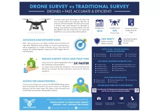
The Drone survey can provide more valuable data than traditional survey methods.<br><br>https://www.helidronesurveys.co.uk/drone-survey-company-infographic/

E N D
DRONE SURVEY vs TRADITIONAL SURVEY DRONES = FAST, ACCURATE & EFFICIENT! Surveying using drone technology is the latest and most accurate method for producing data that all surveyors will find invaluable. The drone gives access to locations that would otherwise be impossible to achieve using traditional surveying methods. Fast and time efficient, pass the savings onto your client and benefit from a new revenue stream that benefits all. completed over 300 Established in 2014 Commercial License Holders from the CAA drone surveys 3RD PARTY operating throughout the UK (London based) ACCURATE AND EFFICIENT DATA With a drone survey you can collect a limitless amount of photo and video data. Utilising this data can help you create accurate reports as well as presenting it in a variety of formats such as: Point Cloud 3D imaging, 2D orthophotographic mapping and GEO tagged data for map integration. liability and public liability insurance SAFETY IS KEY, FORGET SCAFFOLD, LADDERS &PLATFORMS Residential Buildings. Educational Buildings. Institutional Buildings. Business Buildings. Industrial Buildings. Storage Buildings. REDUCE SURVEY COSTS AND FIELD TIME PROVIDING ASSISTANCE IN REPORTS FOR... 5X FASTER Using a drone to capture topographical data is than traditional surveying methods. As using a drone involves less manpower, costs can be reduced and efficiencies increased. The data produced is same day for fast-track operations. Condition surveys End of lease reports Dilapidation reports Home buyers reports Cost-effective approach DEVELOPMENT & MONITORING services MAINTENANCE & INSPECTION services PHOTO MAPPING MINIMAL DISRUPTION OUR CLIENT BASE INCLUDES: Building surveyors Roofing contractors Building management firms RICS surveyors Construction Firms ACCESS THE UNACCESSIBLE... A drone survey will give you access to the IMPOSSIBLE! Being able to direct and position the aircraft to any point in space you will get the birds-eye view from every angle. We collect you the information that would otherwise have been unobtainable in the past. WE CAN ALSO OFFER CPD TO RICS MEMBERS offering more flexibility over traditional surveying methods: DRONE SURVEY VS TRADITIONAL SURVEY: DRONES = FAST, EFFICIENT THE FUTURE! high resolution photographs 4K video same day data turnaround fast response locations: all over the UK including all major cities (London our specialty) http://www.helidronesurveys.co.uk 0800 038 5795