Download

1 / 52

E N D
Topic OneAir Masses and Weather Scientists classify an air mass based on whether it originates in an arctic, in a polar, or in a tropical region and whether it forms over land (continental) or sea (maritime.) An air mass is a large body of air with uniform temperature and humidity. Polar air masses and tropical air masses influence the weather of North America.
Topic TwoFronts and Lows A front is the band of air between opposing air masses. Scientists classify a front based on the temperature of the advancing air mass. Cold and warm fronts are associated with characteristic weather conditions. Fronts are usually connected to mid-latitude, low-pressure systems. Upper level air flow influences the convergence or divergence of air into and out of pressure systems.
Topic FourHurricanes and Winter Storms Hurricanes are large rotating storms originating over tropical oceans. They are classified based on wind speed. Winter storms are middle-latitude, low-pressure systems that occur over land in the winter.
Topic ThreeThunderstorms and Tornadoes Thunderstorms form in warm, moist, unstable air. They produce lightening, a discharge of electricity. Tornadoes can develop in thunderstorms containing rotating updrafts.
Topic FiveForecasting Weather Weather forecasters must gather huge amounts of data in order to make their predictions. They rely on sensing instruments and computer models to provide the information they need. Meteorologists make both daily and long-term forecasts of the weather.
Key Terms air mass blizzard cold front front hurricane lightening occluded front Saffir-Simpson scale squall line supercell tornado thunderstorm station model stationary front storm surge warm front
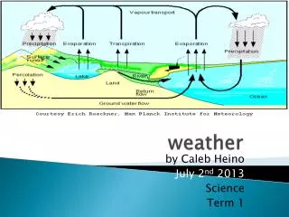
Topic OneAir Masses and Weather Differences in air pressure at different locations on earth create wind patterns. The equator receives more solar energy than the poles, heating the air, causing it to rise. Cold, polar air sinks. As air moves from high to low pressure, a general, worldwide movement of surface air from the poles toward the equator occurs.
Air Mass • A VERY large mass of air that sits over an area for days or weeks and picks up the temperature and humidity characteristics of that area. • They can be thousands of kilometers in diameter.
Continental = Land Maritime = Water Polar = Cold Tropical = Warm
Maritime Polar (mP) • An air mass that forms over a cold, wet area.
Maritime Tropical (mT) • An air mass that forms over a warm, wet area.
Continental Polar (cP) • An air mass that forms over a cold, dry area.
Continental Tropical (cT) • An air mass that forms over a warm, dry area.
Air masses strongly affect the weather on North America. As an air mass moves away from the area over which it formed, it can change. Cold, dry air can become warmer and more moist as it moves from land over the warmer ocean, for example.
cP air masses move southeast from Canada into the United States. It brings very cold, dry air. mP Pacific air masses are moist and cool, but not cold. They bring cool, foggy weather to the Pacific northwest and drop their moisture as the head over the mountain ranges of the western U.S. mP Atlantic air masses move east toward Europe, passing over New England and maritime Canada, bringing cool, cloudy, wet weather.
Topic TwoFronts and Lows When two unlike air masses meet, density differences keep the masses separate. Cool air is dense and does not mix with warm, less dense air. In order for a front to form, one air mass must collide with another.
Front • A place where two different air masses meet.
Cold Front The boundary between an advancing cold air mass and the warm air mass it is displacing.
The moving cold air pushes up the warm air. If the air is moist, large cumulus and cumulonimbus clouds form. Short-lived, sometimes violent storms result. A squall line, a line of heavy thunderstorms, may occur just ahead of a fast-moving cold front. Slow-moving cold fronts produce little rain and less cloudiness.
Warm Front The boundary between an advancing warm air mass and the cold air mass it is displacing.
The slope of a warm front is gradual. This allows clouds to appear a long time before the base of the front. Precipitation is produced over a large area.
Occluded Front The front that is formed when a cold front overtakes a warm front and displaces it upward in an area of low pressure.
The advancing cold front comes in contact with the cool air underneath the lifted warm air, cutting off the warm front from the ground below, holding it high in the atmosphere.
When two air masses meet and neither is displaced, a stationary front results. The two air masses move parallel to the front between them. The weather around a stationary front is similar to that produced by a warm front.
Ananticyclone is the opposite of a cyclone, which sinks and flows out from the center. Because of the Coriolis Effect, the circulation around an anticyclone is clockwise in the Northern Hemisphere. Cyclones bring cloudy, stormy weather, while anticyclones bring dry weather. If an anticyclone stalls over an area, it can cause air-pollution problems.
During a thunderstorm, clouds release electricity in the form of lightening. The released electricity heats the air, causing it to expand rapidly. The expansion and release of the air causes thunder.
Squall Line • A line of thunderstorms that occur ahead of a front. There are often strong winds before the rain. • Strong winds often precede squall lines. This happens because the rain falling within a thunderstorm causes the air to cool, becoming more dense, and sinking. This is called a downdraft.
Super Cell • A very large, single thunderstorm with very strong updrafts. • Strong winds often precede squall lines. This happens because the rain falling within a thunderstorm causes the air to cool, becoming more dense, and sinking. This is called a downdraft.
Lightning A discharge of electricity from a thundercloud to the ground, to another cloud, or to another spot within the cloud itself.
Tornado • A violent, rotating column of air that extends down from dark clouds and moves overland in a narrow, destructive path. • They may reach speeds of 400 km/hr.
Hurricane • A large, rotating storm of tropical origin with sustained winds of at least 119 km/hr.
They are rarely more than 700 km in diameter, and are most powerful of all storms. They occur in both the Atlantic and Pacific.
They occur when: 1. Warm, moist air evaporates off the surface of the ocean and rises rapidly 2. The moisture condenses, releasing latent energy in the form of heat 3. The heat increases the force of the rising air 4. The patterns continues, sustaining the process
An average hurricane has the same amount of energy as all the electricity used in the U.S. in 6 months.
Storm Surge • A rapid rise in water level along the coast as a hurricane or other tropical storm approaches.
Saffir-Simpson Hurricane Scale • The 1 to 5 scale used to rate a hurricane’s intensity and estimate potential property damage and flooding.
Winter storms are mid-latitude low pressure systems that can bring several types of weather, including heavy snow, ice, and rain. When conditions become severe, a blizzard may occur. A blizzard is characterized by high winds, low temperatures and falling or blowing snow.
To be considered a blizzard, three conditions must be met. 1. Winds exceed 56 km/hr. 2. Temperatures are below - 7˚C. 3. Falling and/or blowing snow reduce visibility.
On the east coast, nor’easters occur over the north Atlantic where extremely heavy snow consisting of a maritime polar air mass is blown from the ocean to the land.
Topic FiveForecasting Weather Weather can be measured at both the surface of the earth and above the surface.
As discussed in the last chapters, at the surface, psychrometers, and barometers are used to measure humidity. Rain gauges measure the amount of precipitation.
RADAR • A method of detecting distant objects and recording their features and properties by looking at the electromagnetic waves that are reflected from their surface.
Coded weather information is put on maps prepared by centers around the world. Cluster of symbols are plotted for each station.
Station Model A picture representation for all of the data that make up a weather report for a particular location at a particular time.