Download
1 / 14
140 likes | 225 Views
Stay informed with the latest updates on Hurricane Earl's path and intensity, as well as the forecast for Tropical Storm Fiona. Learn about potential impacts and projections for Central America and Hispaniola.

E N D
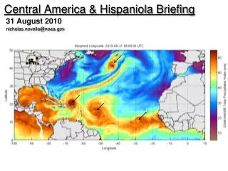
nicholas.novella@noaa.gov Central America & Hispaniola Briefing 31 August 2010
From: Aug 24 – Aug 30, 2010 Flores= 95 mm Tegucigalpa= 80mm San Jose= 93 mm Guatemala= 168 mm Puerto Barrios= 100 mm La Union= 163 mm
Hurricane: “EARL” • - Category 4 • Min SFC P = 931mb(falling) • Sustained winds ~ 130mph (115kts) • In the last 3 days, models continued to shift EARL further west. • General trend (48hrs) – intensifying, after eyewall replacement cycle • Track shifting NW -> N in next 48hrs • Will encounter moderate shear env and cooler SST’s stabilize at Cat 3 weaken • Storm motion to accelerate and become extratropical after 72hrs after Ewrd shift of ST ridge and deep layer trof moves over NE US • Although close, still not expected to pose threat to Hispaniola on near term. • *** For US, much uncertainty ??
Tropical Storm: “FIONA” • Min SFC P = 1007 mb (falling) • Sustained winds ~ 40mph (35kts) • General trend (48hrs) – weakening • Encountering same shear env, likely to remain stable and weaken after next 48hrs. • Convective banding more disorganized, deepest in western semicircle • Likely to mimic NNWrly track of EARL, pass over waters mixed by EARL,