Download
1 / 46
520 likes | 780 Views
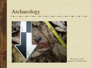
Mesoamerican Archaeology. Olmec Maya Teotihuacan Toltec Aztec. Olmec. 1939 Matthew Stirling was sent by the Smithsonian and National Geographic to investigate giant stone carvings.

E N D
Mesoamerican Archaeology Olmec Maya Teotihuacan Toltec Aztec
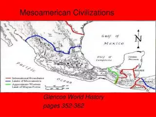
Olmec • 1939 Matthew Stirling was sent by the Smithsonian and National Geographic to investigate giant stone carvings. • Olmec means “dweller in the land of rubber”, refers to people who lived along Gulf of Mexico, southern Veracruz, and western Tabasco. • Olmec lived in this area between 1500 B.C. and 100 A.D.
Characteristic Traits • Building of clay pyramids and temple mounds • Particular sculptural style • weeping or snarling jaguar/human infant • were-jaguar • colossal heads • basalt monuments • Fine jade carving • Basic Mesoamerican civilization • Artifacts with Olmec traits found in preclassic horizons throughout Mesoamerica. • “Cult of the Jaguar” considered a basic Olmec trait.
Important sites • Tres Zapotes • Cerro de las Mesas • San Lorenzo, Veracruz • Oldest Olmec site • Occupied by 1500 B.C. • Pottery found from earliest period • La Venta, Tabasco • Contemporaneous to later phases of San Lorenzo • Oriented on a n-s axis on an island in the Rio Tonala • Includes mounds, plazas, tombs, basalt slab enclosures, and pyramid. • Buried stone offerings • jade and serpentine celts
Maya • Slow, gradual change. • Did not develop overnight. • Due to several factors resource concentration, population growth, beginnings of cultural variability, development of ideologies, migration of ideas from other cultures • Small Kingdoms, No centralized state. • succession of regional centers • not really dominant over neighbors
Regions • Pacific Coastal Plain • Izapa-elaborate stone carvings • Monte Alto-collosal heads (contact with Olmec), also pot belly boulders. • Southeast Periphery • Copan-evidence of interaction with western areas of MesoAm during the preclassic (700-500 B.C.). • Southeastern Highlands • Chalcuapa-one of the important highland centers,important for trade in pottery. • Tikal investigations in the 1950s, national park around the site, 300 B.C. to 300 A.D. developed into a huge city. • Uaxactun basic chronological sequence of pottery for area. • Yucatan Peninsula and Belize • Cerros-exploited marine resources, adopted kingship by 50B.C.
Mayan Writing • Maya codices • most elaborate of writing medium, must have existed in the thousands, but only a few left. • made out of bark paper, or deer skin. • prepared from the inner bark of trees, fibers soaked in lime and then beaten smooth. • once dry it was white-washed with a thin coat of limestoneor gypsum paste. • Stelae • Stone carvings • Most common today
Calendar System • Calender Round • basic unit was a day, not broken down further. • two recurring cycles of time 260-day and 365-day ran simultaneously making up a period of 52 years. • 260-day cycle (Maya:Tzokin, Aztec:Tonalpohualli) • primarily religious and divinatory • guidance of daily affairs • 20 named days, combined with numbers 1-13, in which the exact combination of name and number would recur every 260 days. • not based on natural phenomenon. • 365-day cycle (Maya:Haab, Aztec:Xihuitl) • 18 named months of 20 days each, plus 5 additional days of apprehension and bad luck at the end of the year. • Days numbered from 0-19, and to return to any given date, 52 years would have to pass. • Prophesy that “this world” will end in 2012.
Converting the Mayan Calendar • http://www.pauahtun.org/cgi-bin/mayagreg.py
Agriculture Patterns • Localized intensive agriculture • gardening took place in zones of good moisture. • Expansive Cultivation (900 B.C.) • shifting cultivation • corn farming with swidden or slash/burn, family of five needs 3,000 pounds of corn per year. • Wetland cultivation (Extensive-Intensive) • being increasingly pressed by population. • Chinampas-swamps were being drained and drainage canals built., located with radar imagery. • the largest cities are located on the edges of these swamps.
Settlement Patterns and Population Sizes • No direct evidence for census material, so use indirect means. • Counting house mounds • Volumetric assessments of the masses of formal architecture in the civic centers. • House Structures • small platforms of clay, earth and stone. • Thatched roofs, wattle and daub. • Lowlands areas seem that peak population was Late Classic (A.D. 1000)
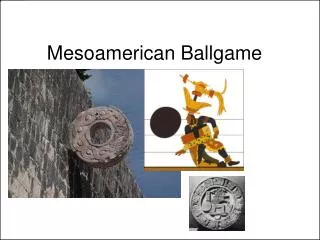
The Mesoamerican Ballgame • Called tlachtli by the Aztecs, game played with hard rubber ball. • Spanish document stone rings as goals, but those dating before 700 A.D. do not have them. • Typically i-shaped courts, balls weighing up to 5 pounds. • ball had to be kept in motion • could not be hit with hands or feet • associated with fertility, death, militarism and sacrifice. • sacrifice of defeated team members docmented in late accounts.
Watch a Ballgame • http://www.ballgame.org/sub_section.asp?section=3&sub_section=1
Basin of Mexico-Teotihuacan • Teotihuacan • Investigated archaeologically first in 1800s, but disastrous results-desturction of monuments. • In 1960s began the Teotihuacan Project. • explore and reconstruct ceremonial centers. • also Basin of Mexico survey project. • Founding of the City • Valley settled as early as 900 B.C., but no large settlement until 300 B.C. • Populated by people from mountains to the east (Tlaxcala). • Several reasons for population move: • caves which are related to religion and mythology. • humans, sun and moon came from center of the earth. • entrance to the Underworld. • network of caves and tunnels under the • Pyramids of the sun and the moon. • close obsidian resources. • nearby springs for irrigation.
Teotihuacan • Size and Construction • At its height, around 125,000 people and covering 22 sq kilometers. • More ceremonial centers than any other prehispanic site. • Planned and laid out along a rectilinear network of roads and paths. • Avenue of the Dead-major north to south axis. • East and West Avenues divided the city into quadrants. • The “citadel” was at their center. • In front of this was the great compound.
Temples and Pyramids • Constructed with Talud-tablero architecture • cut stone facing • Framed panels (tablero) • sloping basal elements (talud) • 5000 known structures. • Pyramid of the Sun • 212 ft high, 700 ft wide, 35,000,000 cu ft of fill (equivalent to 10 modern oil tankers). • cave located underneath with sacred objects in it. • Pyramid of the Moon • located at the north end of the avenue of the dead. • Temple of the Feathered Serpent (at the Citadel) • Residential structures • apartment compounds
Decline of Teotihuacan • During the period from 600-900 A.D. • Site not abandoned, but population decreased. • Some buildings burned between 600-700 A.D. • may be symbolic as in the case of the Olmec destroying heads, associated with the loss of power.
Tula and the Toltecs • A.D. 900-1200 • Development of city north of Teotihuacan after its collapse in 900 A.D. • located on the Tula river and near the Lerma rivers for easy communication with others. • this new capital was closer to the northern limits of agriculture. • Toltec history embellished by Aztecs, Spaniards and others after their collapse in 1200 A.D.
Tula Grande • Was occupied during the prime phase of Tula 950-1150 A.D. • 13 km in area, with a population of 30-60,000 residents. • craftspeople, tradespeople, religious leaders, but not farmers. • workshops included manos and metates makers. toolmakers. • city laid out on n-s axis.
Rise of the Aztec • From A.D. 1200 to A.D. 1370 the Basin of Mexico was occupied by various central Mexican peoples. • Chichimec people settled in the area from the North and gradually overcame the people living there at that time. • primarily due to Xolotl, who ruled a somewhat barbaric horde. • Technically squatted in the area of Tenochtitlan and were know as the Mixeca but today Aztecs is more common.
Spanish Arrival: Cortes • Spanish arrive in A.D. 1519 at Vera Cruz. • March inland to Tenochtitlan • Received by Moctezuma II, who was then held captive by Cortes and his men. • Moctezuma II dies, replaced by nephew (dies almost immediately from small pox), replaced by another nephew: Cuahtemoc.
Mexico Revolts • The siege began on May 21, 1521 and lasted for 85 days. • Finally ended when the Spanish captured the northeast section of the city and eventually conquered the remaining Aztecs. • Cuauhtemoc sets our from the city and surrenders to Cortes sometime around August 14, 1521.