Download
1 / 2
20 likes | 167 Views
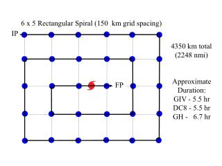
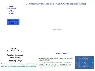
Concurrent Visualization (NASA Goddard and Ames). WRF simulated dBz- 2 min. Shape/size of the eye. NASA Ames Visualization Group. Katrina 2005. Goddard Mesoscale Dynamic and Modeling Group. Resolutions: 15, 5 and 1.667 km Grid size: 300x200, , 418x427, 373x382

E N D
Concurrent Visualization (NASA Goddard and Ames) WRF simulated dBz- 2 min Shape/size of the eye NASA Ames Visualization Group Katrina 2005 Goddard Mesoscale Dynamic and Modeling Group Resolutions: 15, 5 and 1.667 km Grid size: 300x200, , 418x427, 373x382 Dt = 60, 20, 6.67 seconds Starting time: 00Z 8/27/2005 Initial and Boundary Conditions: NCEP/GFS, with bogus but no data assimilation Website for mesoscale modeling group and cloud library http://portal.nccs.nasa.gov/cloudlibrary/index2.html
Hurricane Katrina (2005) Minimum sea level pressure (MSLP) Minimum sea level pressure (MSLP) from the observation and five different WRF experiments using different microphysical schemes Similar temporal variation between model simulated and observed MSLP. All 3ICE schemes over-estimated MSLP (~20-25 hPa), especially Lin scheme (45 hPa lower). No ice case produced strongest hurricane (in the 1st 30 hours). Ice Free Lin Tracks for Hurricane Katrina Tracks for Hurricane Katrina (2005) from the observation and five different WRF experiments using different microphysical schemes (from 00Z 8/27/2005 to 00Z 8/30/2005). Good track forecast in 1st 24 h model integration (less than 25 km because imposed bogus) All schemes’ simulated track is far west after landfall