Download
1 / 12
160 likes | 373 Views
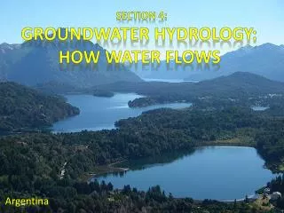
Section 4: Groundwater Hydrology: How Water Flows . Argentina , . http://shortwayup2010.blogspot.com/2010/03/most-beautiful-place-in-world-probably.html.

E N D
Section 4: Groundwater Hydrology: How Water Flows Argentina, http://shortwayup2010.blogspot.com/2010/03/most-beautiful-place-in-world-probably.html
What three questions are central for communities that need adequate drinking water, farmers tending crops and livestock, and engineers working to keep water supplies free of contaminants? • How does water move through the ground and interact • with sediments and rock? • Will an aquifer recharge slowly or quickly after water • is withdrawn? • Where will new • groundwater come • from? http://news.nationalgeographic.com/news/2012/05/120531-groundwater-depletion-may-accelerate-sea-level-rise/ http://www2.epa.gov/enforcement/national-enforcement-initiative-preventing-animal-waste-contaminating-surface-and-ground
The pore structure of soils, sediment, and rock is a central influence on groundwatermovement. Hydrologists quantify this influence primarily in terms of porosity and permeability. • porosity: the proportion of total volume that is occupied by voids, like the spaces within a pile of marbles. Porosity tends to be larger in well sorted sediments where the grain sizes are uniform, and smaller in mixed soils where smaller grains fill the voids between larger grains. Soils are less porous at deeper levels because the weight of overlying soil packs grains closer together. • permeability: how readily the medium transmits water, based on the size and shape of its pore spaces and how interconnected its pores are.
http://geosurvey.state.co.us/apps/wateratlas/chapter2page1.asphttp://geosurvey.state.co.us/apps/wateratlas/chapter2page1.asp
http://cseo.mtu.edu/community/groundwater/GWmyths.htm Each type of soil or rock has a level of permeability, which is a measure of the speed at which water moves through porous material. For example, gravel and sand have higher permeability than clay. Some flow paths are also longer than others.
http://www.clean-water-for-laymen.com/groundwater-sources.htmlhttp://www.clean-water-for-laymen.com/groundwater-sources.html Clay has high porosity and low permeability. Gravel, on the other hand, has a relatively low porosity and high permeability. Groundwater flows through the open spaces in sediment and rock. Layers that have high permeability allow water to move more freely between the pore spaces. Gravel layers yield more water because of their high permeability, so they make better groundwater sources than clay.
List (5) materials with high porosity and high permeability. • sand, gravel, sandstone, fractured rock, and • basalt • List (3) low-permeable rocks and sediments • that impede • groundwater flow. • granite, • shale, and clay http://www.sandatlas.org/rock-types/
38. Groundwater recharge enters aquifers in areas at higher elevations (typically hill slopes) than discharge areas (typically in the bottom of valleys), so the overall movement of groundwater is downhill. However, within an aquifer, water often flows upward toward a discharge area. To understand and map the complex patterns of groundwater flow, hydrogeologists use a quantity called the hydraulic head. The hydraulic head at a particular location within an aquifer is the sum of the elevation of that point and the height of the column of water that would fill a well open only at that point. Thus, the hydraulic head at a point is simply the elevation of water that rises up in a well open to the aquifer at that point.
The rate at which groundwater flows through the matrix materials is determined by the hydraulic pressure and the conductivity of the materials. http://www.colinmayfield.com/biology447/modules/module7/7a.htm
39. The height of water within the well is not the same as the distance to the water table. If the aquifer is under pressure, or artesian, this height may be much greater than the distance to the water table. Because these are usually the only two significant potentials driving groundwater flow, groundwater will flow from high to low hydraulic head. http://education.nationalgeographic.com/education/media/aquifer/?ar_a=1
40. Depending on local rainfall, land use, and geology, streams may be fed by either groundwater discharge or surface runoff and direct rainfall, or by some combination of surface and groundwater. http://www.marlborough.govt.nz/Environment/Groundwater/What-is-Groundwater.aspx