Download
1 / 22
220 likes | 432 Views
Digimap Training Workshops. Ordnance Survey products in Digimap. All available Ordnance Survey products from Digimap:http://edina.ac.uk/digimap/description/products/Date of updates:http://edina.ac.uk/digimap/description/products/revisionpolicy.shtml. Digimap Training Workshops. OS Collection ?

E N D
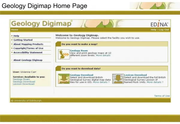
1. Digimap Training Workshops EDINA Digimap
Digimap�s Ordnance Survey Collection:
Data available for download
2. Digimap Training Workshops Ordnance Survey products in Digimap All available Ordnance Survey products from Digimap:
http://edina.ac.uk/digimap/description/products/
Date of updates:
http://edina.ac.uk/digimap/description/products/revisionpolicy.shtml
3. Digimap Training Workshops OS Collection � 5 download facilities Data Download � tiled OS data
MasterMap Download � most detailed mapping available of GB
Boundary Download � postcode data and digital boundary lines
Gazetteer Download � entire 1:50000 Scale Gazetteer
Gazetteer Plus � selected records from 1:50000 Scale Gazetteer
4. Digimap Training Workshops Data Download 15 data products available � see next 2 slides
Some products available in more than one format � EDINA has no influence on the formats available
See the EDINA training document �OS Collection: data formats and conversion guidance�, for information on the different data formats
5. Digimap Training Workshops Data Download products These products are available for download under the terms of the Digimap agreement with Ordnance Survey.
You cannot download these products from the OS OpenData website.
6. Digimap Training Workshops Data Download products These products are also available to download via the OS OpenData website
Digimap offers a search function and the ability to download data solely for your area of interest, whereas OS OpenData offers GB, country or 100 x 100km tiles.
7. Digimap Training Workshops MasterMap Download Detailed mapping of GB, this product is a database, divided into different product layers
EDINA Digimap has 2 layers available for download
8. Digimap Training Workshops MasterMap Download layers Topography and Integrated Transport Network layers available
Download 1 layer at a time � possible to select and download the themes of interest to you
9. Digimap Training Workshops MasterMap Download
10. Digimap Training Workshops Boundary Download
11. Digimap Training Workshops Boundary Download Home Page
12. Digimap Training Workshops Postcode data OS Code-Point: National Grid co-ordinates for a point within each postcode unit in Great Britain
OS Code-Point Polygons: Digital postcode unit boundaries
Available at area level (e.g. AB, CF) or district level (AB1, AB2 etc). District level not available in NTF format. Code-Point provides a precise geographical location for each postcode unit in the United Kingdom. There are�approximately 1.7 million postcode units in England, Scotland and�Wales, with Northern Ireland's BT postal area�accounting for �approximately 46 900 postcodes. Each postcode unit, such as KY12 8UP or PO14 2RS, contains an average of fifteen adjoining addresses.
Features and benefits
An economical planning or marketing tool for users not requiring individual addresses.
Includes National Health Service and local government area codes down to ward level.
Geographical location for Code-Point is taken from Ordnance Survey's Addressing data.
Code-point:
Area Data � choose up to 5 areas, e.g. AB for Aberdeen, CF for Cardiff and so on. Your download then contains all the districts within that area, e.g. if you choose Aberdeen as an area you will get AB1, AB2 etc.
District Data � with this option, you choose one area, then you can select the districts e.g. the AB1, AB2, of your choice.
Code-Point provides a precise geographical location for each postcode unit in the United Kingdom. There are�approximately 1.7 million postcode units in England, Scotland and�Wales, with Northern Ireland's BT postal area�accounting for �approximately 46 900 postcodes. Each postcode unit, such as KY12 8UP or PO14 2RS, contains an average of fifteen adjoining addresses.
Features and benefits
An economical planning or marketing tool for users not requiring individual addresses.
Includes National Health Service and local government area codes down to ward level.
Geographical location for Code-Point is taken from Ordnance Survey's Addressing data.
Code-point:
Area Data � choose up to 5 areas, e.g. AB for Aberdeen, CF for Cardiff and so on. Your download then contains all the districts within that area, e.g. if you choose Aberdeen as an area you will get AB1, AB2 etc.
District Data � with this option, you choose one area, then you can select the districts e.g. the AB1, AB2, of your choice.
13. Digimap Training Workshops OS Code-Point Also provided: NHS region, NHS authority, County, District, Ward, Postcode Type
14. Digimap Training Workshops OS Code-Point
15. Digimap Training Workshops OS Code-Point Polygons
16. Digimap Training Workshops Boundary Line Available: County, European constituencies, Greater London Authority, Metropolitan districts, Scottish parliamentary electoral region, Unitary Authorities, Westminster constituencies, Extent of the realm
Boundary datasets for use with census datasets, available in UKBORDERS: http://edina.ac.uk/ukborders/
Features and boundaries incorporated in Boundary-Line
County -�The named� county, district, district ward, civil parish, county electoral division (ED).
European constituencies - The named European region.
Greater London Authority� - The Greater London Authority, Greater London Authority Assembly constituency, London borough, London borough ward.�
Metropolitan districts - The named metropolitan district, metropolitan district ward, civil parish where appropriate.�
Scottish parliamentary electoral region - The named Scottish Parliamentary�electoral region, Scottish parliamentary constitiuency.
Unitary authorities- The named unitary authority, unitary authority ward or unitary�authority ED as appropriate, civil parish where appropriate, together with community in Wales.
Welsh Assembly Electoral Region - The named Welsh Assembly electoral region, Welsh assembly constituency.
Westminster constituencies - The named Westminster constituency.�
Extent of the realm - �Low water mark or seaward boundary extension.
High water mark
Unique identifiers -� �For administrative areas, polygons and links.
Area measurements
Definitive names
Census codes
17. Digimap Training Workshops Boundary Line
18. Digimap Training Workshops Boundary Line Greater London Constituencies, labelled, 1:25000 Raster background
19. Digimap Training Workshops GB National Boundaries & Grids National Boundaries have been derived from Ordnance Survey�s Strategi data
National Grids have been created by Ordnance Survey
20. Digimap Training Workshops Gazetteer Download
21. Digimap Training Workshops Gazetteer Plus
22. Digimap Training Workshops Gazetteer Plus
23. Digimap Training Workshops Gazetteer Plus - example use