Download
1 / 29
290 likes | 584 Views
Geology Digimap. Geology RoamGeology DownloadUsing geological map data in ArcGIS. Geology Roam. Navigation and hints/tips. Task menu: Search, Customise, Active Legend, Map info., Save, Geological Photos. Tools: fade out maps, annotate, measure, print. Search

E N D
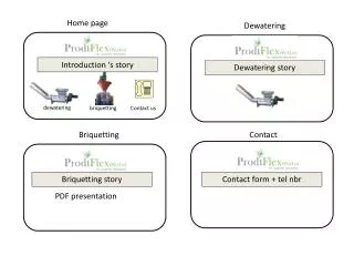
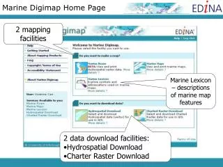
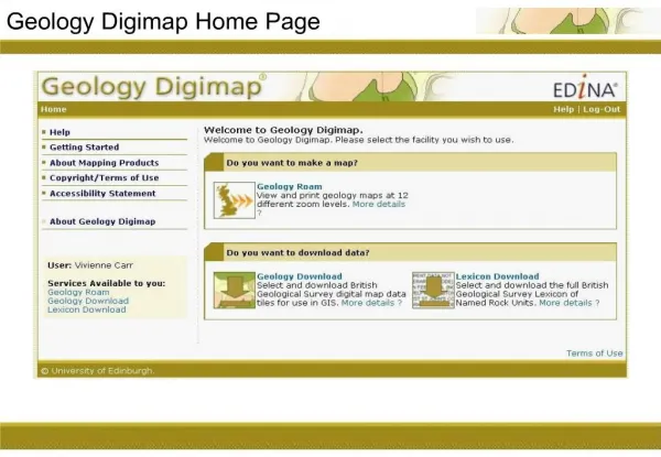
1. Geology Digimap Home Page
3. Geology Roam
4. Search � place name
5. Search - place name
6. Search - place name Place name database - 1:50000 Scale Gazetteer
Any place name on OS Landranger maps can be used
Street names cannot be used
7. Search � place name
8. Postcode search
9. Postcode search
10. Grid reference search
11. Grid reference search
12. Map Views
13. Panning
14. Zooming
15. Map Content Control
16. Map Content Control
17. Map fade slider
18. Map fade slider
19. Map fade slider
20. Map Information
21. Geological Photos
22. Geological Photos
23. Geology Roam JIDI images JIDI Image links:
http://edinadigimap.blogspot.com/2010/09/geological-photos-in-geology-roam.html
Over 3000 images mainly found in geologically rich areas such as Cumbria, North and South Wales, the Dorset coast, Edinburgh etc. The images cover a wide range of features from details of bedding planes and large crystals in rock faces to aerial photographs of valleys showing glacial erosion features.
Available at 5 most detailed zoom levels in Geology Roam
24. My Maps
25. My Maps
26. My Maps
27. Feature info.
28. Feature info. Click on any area of the map for info.
Places marker and highlights polygon
29. Active Legends Active Legend displays all the rocks shown on your current map
Sort Alphabetically or by Frequency
30. Active Legends Select a rock in the legend, or on the map � the rock is highlighted on the map
31. Active Legends By default, the legend does not automatically update when you pan around or zoom in or out
Options to change the default settings at bottom of legend
32. Annotation tools Click icon to activate annotations toolbar
33. Measurement tools Click icon to activate measurement tools
Box appears with distance/area measurement options
34. Print
35. Print
36. Print
37. Geology Digimap Geology Roam
Geology Download
Using geological map data in ArcGIS
38. Geology Digimap Download
39. Geology Digimap data Recently added dataset: DigBath250 � vector digital bathymetry of UK
http://www.bgs.ac.uk/products/digbath250/
Mapping and modelling of the sea bed and sub seabed. It may also be useful for regional scale tidal, current and water column modelling. Includes the whole of the UK continental shelf and slope and extends into adjacent European waters to cover the whole of the Irish Sea and North Sea.
BGS now make some data freely available to academic community via their Open GeoScience website
40. BGS OpenScience
41. BGS OpenScience Maps Section
42. BGS OpenScience Data Downloads Section
43. Geology Digimap Geology Roam
Geology Download
Using geological map data in ArcGIS
44. Access Geology Download
45. Geology Download interface
46. Step 1: Select product/format Select product
Choose data format:
Shape (ArcGIS)
MID/MIF (MapInfo)
47. Step 2: Searching for data Select a location search method
48. Step 3: Select tiles
49. Step 4: Download settings Archiving and compression
Unix, PC, Mac?
Large numbers of component files mean no individual file downloads
All downloads delivered in .zip or .tar archives
50. Step 5: Downloading Right-click, �Save link as..� or �Save Target As��
51. Geology Digimap Geology Roam
Geology Download
Using geological map data in ArcGIS
52. Geology Download - file contents For each SHP or MIF/MID file downloaded, an AVL file is supplied.
AVL, or layer, files, allow us to style the data in GIS with BGS cartography.
53. Geology data in ArcGIS Step 1 � add the Shape files
54. Geology data in ArcGIS Step 2 � view the unstyled data layers
55. Geology data in ArcGIS Apply AVL files to each Shape file
56. Geology data in ArcGIS View styled data