Download
1 / 5
50 likes | 191 Views
AQAST FY14 - Tiger Team Project Overview `. Web-Enabled Tools for Air Quality Management Decision Support NASA Air Quality Applied Sciences Team (AQAST) 6th Biannual Meeting Rice University January 15-17, 2014. Web-Enabled Tools for Air Quality Management Decision Support. Project Team:

E N D
AQAST FY14 - Tiger Team Project Overview` Web-Enabled Tools for Air Quality Management Decision Support NASA Air Quality Applied Sciences Team (AQAST)6th Biannual MeetingRice UniversityJanuary 15-17, 2014
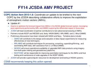
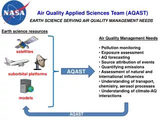
Web-Enabled Tools for Air Quality Management Decision Support Project Team: Lead PIs: Jim Szykman (USEPA ORD) and Scott Spak (U. Iowa) AQAST Members: Greg Carmichael(u. Iowa) , Daven Henze (CU Boulder), Dick McNider (UAH), Brad Pierce (NOAA/NESDIS) TT Specific Members: Todd Plessel and Matt Freeman (USEPA/NCC/L-M), Hyun-Deok Choi, NIA NASA-LaRC AQ management contacts: Terry Keating, Susan Anenberg (USEPA OAR), Rohit Mathur (USEPA ORD), Chris Misenis, Sharon Phillips (USEPA OAQPS), David Lighthall (SJVAPCD), Matthew Johnson (IA DNR) Tiger Team Project Objective: Extend development of an interoperable web-based infrastructure to highlight added value of NASA satellite data for model evaluation, constraints on emission fields, and present data in a user-ready and policy relevant manner. Project leverages existing and new AQAST connections and efforts involving: model evaluation and adjoint modeling under Task Force on Hemispheric Transport of Air Pollution (TF-HTAP) and UNEP Climate and Clean Air Coalition (CACC), UAH Physical model evaluation activities of GOES and MODIS cloud and surface properties for numerical model evaluation, and EPA funded development of Remote Sensing Information Gateway (RSIG) Application and Cyberinfrastructure Best Practices under CyAir. Outcome: Part of a user-agency supported common infrastructure for delivery satellite and model data sets and tools from AQAST.
Web-Enabled Tools for Air Quality Management Decision Support • Existing global (GEOS-Chem) and regional model simulations (source-receptor and model sensitives) results exist outside TT project in support of TF-HTAP and CCAC. • Develop web service to access and visualize results in policy relevant manner via RSIG application. RSIG User Visualization of complex modeling results in a policy relevant manner Combine GEOS-Chem adjoint sensitivities with TES IRKs: Estimate location-specific Radiative Forcing contributions by species: Bowman and Henze, 2012
Web-Enabled Tools for Air Quality Management Decision Support • Leverage existing AQAST efforts supporting satellite-measurement model evaluation under TF-HTAP. • Begin to incorporate satellite–to-model evaluation methods into AQAST web-based tools and RSIG application for continued use user applications. • Where feasible, include application of satellite average kernels. • Outputs to include basic satellite-to-model comparative statistics. Add figure with camx vs airs
Web-Enabled Tools for Air Quality Management Decision Support • Develop and Implement UAH-RSIG web service (OGC-WCS) to increase user access to satellite products for use in WRF/CMAQ/CAMX. • Add functionally for user to use local model grid definition files to re-rid satellite data to model domain. New UAH Archive Products to be served via RSIG 1. GOES Cloud Albedo 2. GOES Surface Albedo 3. GOES Cloud Top temperature 4. GOES Optical Cloud Depth 5. GOES Photosynthetic Active Radiation (PAR) 6. GOES Land Surface (skin) Temperature 7. MODIS Land Surface (skin) Temperature (this is already being served by RSIG but we will add the automatic grid generation) For Photolysis Calculations For Biogenic Emissions Data request with grid definitions User EPA-RSIG SERVERS For model Evaluation Satellite Data in Model Grid Model Input File MODIS skin temperatures