Download
1 / 28
370 likes | 888 Views
Chapter 5 Physical Geography of the United States and Canada: A Land of Contrasts. North America’s vast and varied landscape and abundant resources have attracted immigrants and shaped the development of the United States and Canada. Section 1: Landforms and Resources

E N D
Chapter 5Physical Geography of the United States and Canada: A Land of Contrasts North America’s vast and varied landscape and abundant resources have attracted immigrants and shaped the development of the United States and Canada.
Section 1: Landforms and Resources • Section 2: Climate and Vegetation • Section 3: Human-Environment Interaction
Section 1: Landforms and Resources • The United States and Canada have vast lands and abundant resources. • These two countries share many of the same landforms.
Section 1: Landforms and Resources Landscape Influenced Development Anglo America • U.S., Canada are both former Britishcolonies, most people speak English. • Strong economic and with one another along with sharing physical geography. Vast Lands • Extend across North America from Atlantic on the east to Pacific on the West, From the Arctic in the North to the Gulf of Mexico in the south. • Canada second largest country in the world by area; U.S. third. • Together they cover one-eighth of the earth’s land surface
Landscape Influenced Development Abundant Resources • Landmass and richness in natural resources attract immigrants to both countries. • U.S. and Canada have developed into global economic powers
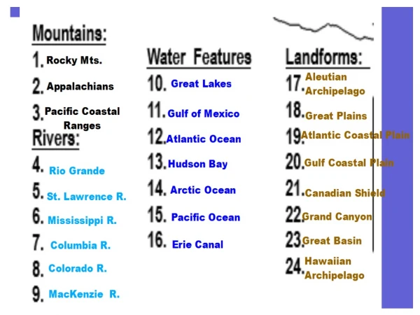
Many and Varied Landforms Major Landforms • All major landforms are found in U.S. and Canada • The two countries share mountain chains and interior plains The Eastern Lowlands • A flat coastal plain runs along the Atlantic Ocean and Gulf of Mexico. Excellent locations for harbors. • Atlantic Coastal Plain extends from Delaware down to Florida. • Gulf Coastal Plain goes from Florida, along Gulf of Mexico, to Texas • Also in this area is the Piedmont—low plateau between coastal plains and Appalachian Highlands
Many and Varied Landforms The Appalachian Highlands • Appalachian Mountains run 1,600 miles from Newfoundland to Alabama - include Green and Catskill mountains in the north - Blue Ridge and Great Smoky mountains in the south • More than 400 million years old • Erosion has created gentle slopes, peaks from 1,200–2,400 feet • The Appalachian Trail is a scenic hiking path along the chain
Many and Varied Landforms The Interior Lowlands • Huge area of mainly level lands covering the interior of North America. • Glaciers leveled the land and left fertile soil. • Interior Plains extend from Appalachians to Missouri River • Great Plains extend from Missouri River to Rocky Mountains • Canadian Shield—vast, flat area around Hudson Bay
Many and Varied Landforms The Western Mountains, Plateaus, and Basins • West of the plains are the massive, rugged Rocky Mountains. • Rocky Mountains run 3,000 miles from Alaska to New Mexico • Relatively young: 80 million years old • Less erosion means rugged, 12,000-foot, snow-covered peaks • Continental Divide—the line of highest points along the Rockies - separates rivers that flow eastward from those that flow westward
Many and Varied Landforms The Western Mountains, Plateaus, and Basins • Other Pacific mountain ranges: Sierra Nevada, Cascade • Continent’s highest peak: Mt. McKinley in Alaska • Major earthquake activity in Pacific ranges • Between ranges and Rockies: cliffs, canyons, basins (low desert) The Islands • Canada’s large, northern islands: Ellesmere, Victoria, Baffin are huge, and only Greenland is bigger in North America. • U.S.: Aleutians (Alaska), Hawaiian (politically, not geographically) Both created by volcanic activity.
Resources Shape Ways of Life Oceans and Waterways • U.S. and Canada are bounded by: - Atlantic, Pacific, Arctic oceans - Gulf of Mexico • Countries have many large, inland rivers and lakes that provide: - transportation, hydroelectric power, irrigation, fresh water, fisheries
Resources Shape Ways of Life Oceans and Waterways • 8 of the worlds largest lakes are found in this region. Among these are the Great Lakes • Great Lakes: Huron, Ontario, Michigan, Erie, and Superior • Mississippi-Missouri-Ohio river system: continent’s longest, busiest • Mackenzie River: longest in Canada, crosses Northwest Territories
Resources Shape Ways of Life Land and Forests • One of the richest natural resources in the US and Canada is the land. • Fertile soil helps make North America world’s leading food exporter. Much of the agricultural land is found in the plains. • Large forests yield lumber and other products. Minerals and Fossil Fuels • Mineral quantity and variety make rapid industrialization possible - Canadian Shield: iron ore, nickel, copper, gold, uranium - Appalachians, Great Plains: coal - Gulf of Mexico: oil, natural gas • U.S.: biggest energy consumer, it actually gets most of Canada’s energy exports.
Section 2: Climate and Vegetation • Almost every type of climate is found in the 50 United States because they extend over such a large area north to south. • Canada’s cold climate is related to its location in the far northern latitudes.
Section 2: Climate and Vegetation Shared Climates and Vegetation U.S and Canada Climates • U.S. has more climate zones than Canada • U.S.: moderate mid-latitudes, Canada: colder high latitudes • US and Canada share climate like the one along the border of Alaska and Canada, and also the northern border of the US and Southern border of Canada. Colder Climates • Arctic coast is tundra: huge, treeless plain with long, cold winters - some permafrost which means there is permanently frozen ground • Rockies and Pacific ranges are highland: colder, sparse vegetation -affect weather in lower areas: block Arctic air, trap Pacific moisture which makes in rainy on the western side of the mountains and those on the east are very dry.
Shared Climates and Vegetation Moderate Climates • North central, northeast U.S, southern Canada are humid continental - cold winters; warm summers; heavy agriculture. Canadian summers are short while US has longer summers. Mostly temperate grasslands to the west of Mississippi River and to the east are deciduous forests. • Pacific coast has marine west coast climate - warm summers; long, mild, rainy winters; mixed vegetation - climate affected by ocean currents, coastal mountains, westerlies - prevailing westerlies—middle-latitude winds blowing west to east
Differences in Climate and Vegetation Milder Climates • Much of U.S. located south of 40 degrees N latitude - milder, dry, and tropical climates • Southern states are humid subtropical - hot summers; mild winters; long growing season for variety of crops • Central, southern California coasts have Mediterranean climate - dry, warm summers; mild, rainy winters; fruits, vegetables grow well
Differences in Climate and Vegetation Dry Climates • Great Plains, northern Great Basin semiarid: dry with short grasses • Southwest is hot, dry desert, including Mojave and Sonoran deserts Tropical Climates • Hawaii is tropical wet: rain forests, temps around 70 degrees F - Mount Waialeale on Kauai Island is one of the wettest spots on earth • South Florida is tropical wet and dry: warm with tall grasses - Everglades— swampland covering 4,000 square miles
Effects of Extreme Weather Natural Hazards • Warm Gulf air clashes with cold Canadian air over the Great Plains - creates thunderstorms, tornadoes, blizzards • Hurricanes sweep the Gulf and Atlantic coasts in summer and fall • Heavy rains cause floods along big rivers like the Mississippi • Heat, lack of rain bring droughts, dust storms, forest fires
Section 3: Human-Environment Interaction • Humans have dramatically changed the face of North America. • European settlements in the United States and Canada expanded from east to west.
Section 3: Human-Environment Interaction Settlement and Agriculture Alter the Land Settlement • Before humans, land changed due to natural forces: weather, erosion • Human settlers adapted to, and changed, the environment • First North Americans were nomads, moving from place to place - migrated from Asia over Beringia, a land bridge from Siberia to Alaska - hunted, fished, and gathered plants; settled near rivers and streams
Settlement and Agriculture Alter the Land Agriculture • Agriculture replaced hunting and gathering 3,000 years ago • Settlements became permanent - cut down trees for houses, plow fields, dig irrigation ditches - plant corn, beans, squash • Today U.S. and Canada are leading agriculture exporters
Building Cities Where Cities Grow • Water access a major factor in how towns begin, develop • Other factors: landscape, climate, weather, natural resources Montreal—Adapting to the Weather • Canada’s second-largest city; major port located on island in Quebec - meeting of St. Lawrence and Ottawa rivers make it important trade site • French build permanent settlement in 1642 at base of Mount Royal • Cold winters force people to stay inside and build underground areas
Building Cities Los Angeles—Creating Urban Sprawl • Mild climate and the ocean bring thousands to area in early 1900s - once-small Spanish settlement expanded into valleys and foothills • Becomes U.S.’s second-largest city in 1980s - problems: air pollution, low water supply, earthquake area • Los Angeles has spread out over a large area - city proper: 469 square miles; metropolitan area: 4,060 square miles
Overcoming Distances Since the area is so big, the people of the US and Canada had to find ways to overcome the distances, here they are: Trails and Inland Waterways • First natives go east, south down Pacific coast; some remain north • Europeans colonize the east coast then go inland, creating trails - national and Wilderness roads, Oregon and Santa Fe trails - use Mississippi and Ohio rivers; build canals - Erie Canal—first navigable water link between Atlantic, Great Lakes
Overcoming Distances Trails and Inland Waterways • St. Lawrence Seaway—deepwater ship route built by U.S. and Canada • Connects Great Lakes to Atlantic by way of St. Lawrence River • Gated-off sections called locks raise and lower the water and ships • Large ocean vessels can get to industrial and agricultural heartland
Overcoming Distances Transcontinental Railroads • Transcontinental—from the Atlantic Ocean to the Pacific Ocean • Builders of early-1800s railroads face many natural barriers - workers cut down forests, bridge streams, tunnel through mountains • First U.S. transcontinental railroad: 1860; first Canadian: 1885 • Move goods, people; promote economic development, national unity • Today U.S. has world’s largest rail system; Canada, third largest
Overcoming Distances National Highway Systems • Arrival of automobile spurs road building in early 20th century • Today U.S. has 4 million miles of roads, Canada has 560,000 miles • Large Canadian highways connect major southern cities from east to west - Trans-Canada Highway: 4,860 miles, Newfoundland to British Columbia • U.S. interstate highway system: 46,000-mile network begun in 1950s