Download
1 / 52
530 likes | 798 Views
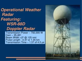
Acquisition and Use of NEXRAD and FAA Doppler Weather Radar Data. Presented to the Monroney Aeronautical Center 9 November 2000 Kelvin K. Droegemeier Center for Analysis and Prediction of Storms and School of Meteorology University of Oklahoma. NEXRAD Doppler Radar Network.

E N D
Acquisition and Use of NEXRAD and FAA Doppler Weather Radar Data Presented to the Monroney Aeronautical Center9 November 2000 Kelvin K. DroegemeierCenter for Analysis and Prediction of Storms andSchool of MeteorologyUniversity of Oklahoma
NEXRAD Facts and Figures • 158 radars (141 in the Continental US) • 120 National Weather Service radars • 26 Department of Defense radars • 12 Federal Aviation Administration radars
NEXRAD Data Types • Archive Level I (raw receiver data) • Level II data (digital data in spherical coordinates at full resolution) • Archive Level III (digital products) • Archive Level IV (forecaster-generated products)
NEXRAD Data Types • Archive Level I (raw receiver data) • Level II data (digital data in spherical coordinates at full resolution) • Archive Level III (digital products) • Archive Level IV (forecaster-generated products)
NEXRAD Product Data (NIDS) • 24 products available from all CONUS radars in real time • Lowest 4 elevation angles only • Low-precision because values are quantized (e.g., 0-5, 5-10, 10-15)
NEXRAD Data Types • Archive Level I (raw receiver data) • Level II data (digital data in spherical coordinates at full resolution) • Archive Level III (digital products) • Archive Level IV (forecaster-generated products)
NEXRAD Base (Level II) Data • Full resolution digital data • Full data precision • All elevation angles • Not available in real time except for selected sites (more on that later) • This data set is the focus of our efforts
Base Data Usage: NSSL Warning Decision Support System on 3 May 1999 Courtesy National Severe Storms Laboratory
Trimmed Detections and Ground Truth Damage Paths Hits (142) Misses (25) FAs (21) Courtesy D. Zittel
The Value of NEXRAD Radar Data for Numerical Storm Prediction: The 3 May 1999 OklahomaTornado Outbreak Copyright 1999 The Daily Oklahoman
CAPS Numerical Forecasts of the May 3 Tornadic Storms 5:00 pm - Model Initialization Time Storm Beyond Velocity Range of NEXRAD NEXRAD Radar Observations ARPS Prediction Model (0 hour forecast)
CAPS Numerical Forecasts of the May 3 Tornadic Storms 5:30 pm - 30 min Forecast Model Generates the Storm Itself NEXRAD Radar Observations ARPS Prediction Model (1/2 hour forecast)
CAPS Numerical Forecasts of the May 3 Tornadic Storms 6:00 pm - 1 hour Forecast NEXRAD Radar Observations ARPS Prediction Model (1 hour forecast)
CAPS Numerical Forecasts of the May 3 Tornadic Storms 6:30 pm - 1.5 hour Forecast Strong Mesocyclone Present Tornado on the Ground NEXRAD Radar Observations ARPS Prediction Model (1 1/2 hour forecast)
CAPS Numerical Forecasts of the May 3 Tornadic Storms 7:00 pm - 2 hour Forecast NEXRAD Radar Observations ARPS Prediction Model (2 hour forecast)
Forecasts With and Without NEXRAD Data WITHOUT WITH Moore, OK Tornadic Storm 2-Hour CAPS Computer Forecast Down to the Scale of Counties NEXRAD Radar Observations
Summary: WSR-88D Radar Data • The scientific and operational communities need base data (real time and archived) • Although NIDS data are available in real time from all WSR-88D radars, they are insufficient for many applications (NWP, hydrology) • Degradation of precision • Only the lowest 4 tilts are transmitted • Base data currently are not available in real time • Originally would have been expensive • Presumed large volume of data (10 mbytes/5 min/radar) • Need wasn’t there 10 years ago • The technology and need now exist to prototype the direct acquisition, use, and archival of base data in real time
The Collaborative Radar Acquisition Field Test (CRAFT) • Establish a prototype real time WSR-88D base data acquisition test bed to • Evaluate strategies for compressing and transmitting base data in real time • Develop efficient and cost-effective strategies for direct digital ingest, archive, and retrieval at NCDC • Assess the value of base data in numerical weather prediction • Test web-based data mining techniques for rapid perusal/access of base data by the scientific community
Technical Strategy Dedicated 56K line ($2000 - $6000/year) Server Cisco 1600 Series Router($2000) Internet Linux PC Unidata LDM ($1500) Users At the radar site WSR-88D RIDDS Repeater Hub
Abilene NetworkJanuary 1999 Abilene Router Node Abilene Access Node Operational January 1999 Planned 1999 Seattle Cleveland New York Sacramento Denver Indianapolis Kansas City Los Angeles Atlanta Houston
New Concept: Abilene/Internet2 + NEXRAD U-WA NCEP AWC NCAR/FSL NCDC OU TPC
Some Examples GOES Visible, 2245 Z 4 June 1998 KFWS Composite Reflectivity 00 Z, 4 June 1998
Sample Aviation Products Cloud Type and LWC at FL 050 Cloud Type and LWC at FL 320 Cloud Type and LWC N/S X-Section
Sample Aviation Products Downburst Potential Surface Isotachs & Streamlines CAPE & Helicity
Sample Aviation Products Surface Visibility Clear-Air Turbulence Icing Potential
Statistical Climatologies of Storm Characteristics (location, intensity, movement, initiation, decay) relative to NAS assets Pugh (2000)
The Future: FAA Radars • The CRAFT concept can be extended to include FAA radars that process weather information • TDWR (terminal Doppler weather radar) • ASR (airport surveillance radar) • ARSR (air route surveillance radar)
TDWR Weber (2000)
Airport Surveillance Radars (ASR-9) Weber (2000)
Airport Surveillance Radars (ASR-9) Weber (2000)
Airport Surveillance Radars (ASR-11) Weber (2000)
Air Route Surveillance Radars (ARSR-4) Weber (2000)
The Result • An integrated, national data set of highly detailed weather radar information for use in • Numerical weather prediction • Real time air traffic control and planning • Research of specific relevance to aviation • The radar data can be used to create “assimilated” data sets that provide all meteorological variables at high resolution • We’re positioning Norman to serve as a national data repository for real time access
Funding Status • NOAA ESDIM Grant funded (CAPS+NSSL+OSF+NCDC) • $540K/3 years • Research Thrusts • Test of direct ingest/archival at NCDC • Improve compression algorithms • Initial work on web-based data mining • NOAA earmark funding to OU • $474K for 1 year • Expand CRAFT to 30 radars (CRAFT-2) • Develop data assimilation capabilities for the WRF model • Kelvin doing a mini-sabbatical at the NSSL this fall • HPCC Proposal ($150K for 1 year, about to be funded) • Data mining • Network quality of service research • Hardware for additional radars