Download

1 / 24
240 likes | 406 Views
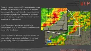
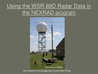
Unlocking the Scientific Value of NEXRAD Weather Radar Data. Witold F. Krajewski with Anton Kruger, Ramon Lawrence, Allen A. Bradley, and Grzegorz J. Ciach. Two Issues:. Hydrologic use of NEXRAD data: (NSF funded NEXRAD Hydro-ITR project)

E N D
Unlocking the Scientific Value of NEXRAD Weather Radar Data Witold F. Krajewski with Anton Kruger, Ramon Lawrence, Allen A. Bradley, and Grzegorz J. Ciach
Two Issues: • Hydrologic use of NEXRAD data: (NSF funded NEXRAD Hydro-ITR project) • Probabilistic QPE (OHD initiative towards ensemble based hydrologic prediction)
NEXRAD Hydro-ITR Project • The University of Iowa (Lead) • W.F. Krajewski (PI) • A.A. Bradley, A. Kruger, R.E. Lawrence • Princeton University • J.A. Smith • M. Steiner, M.L.Baeck • National Climatic Data Center • S.A. Delgreco • S. Ansari • UCAR/Unidata Program Center • M. K. Ramamurthy • W.J. Weber
Project Premise • Rainfall is a key component of the hydrologic cycle • NEXRAD data have potential to provide surface rainfall estimates • Reality: NEXRAD data are severely underutilized in the hydrologic sciences
Why? Current methods of accessing NEXRAD data require considerable expertise in: • Weather radar operations • Radar data quality control • Formatting and data handling • Radar-rainfall algorithms These are significant obstacles – often show-stoppers.
Project Goal …to provide the science (hydrologic) community with ready access to the vast archives and real-time information collected by the national network of NEXRAD radars. Again The main focus is on radar-rainfall data for use in hydrology, hydrometeorology, and water resources.
What Does This Mean? Rather than saying: “Get the Level II data for the KDVN Iowa NEXRAD (KDVN) for the 16 July 2002 severe weather outbreak. Show a 2 km CAPPI of reflectivity and cross-section of Doppler velocity” a hydrologist wants to say “Find all the 2002 storms over the Ralston Creek watershed with mean arealprecipitation greater than X mm, and with a spatial extent of more than Z km2, with a duration of less than N hours. I want the data in GeoTIFF”
Hydrology Centered View “Find all the 2002 storms over the Ralston Creek watershed with mean arealprecipitation greater than X mm, and with a spatial extent of more than Z km2, with a duration of less than N hours. I want the data in GeoTIFF” • Basin-centered • Name, USGS HUC, etc. • Precipitation • MAP, Rain amount, … not Reflectivity Z • Georeferencing • Location, spatial extent • Data Format • GeoTIFF, NetCDF => use in GIS Encode expertise in software system
IT Issues • Open source vs. commercial software, Java • Data formats: NetCDF & HDF • Front end/client & back end /server • Linux vs. Windows • XML, XML Schema, OWL • Metadata standards (Federal, USGS) • Interfaces with DLESE, NSDL, THREDDS • LDM/IDD • Web services: SOAP, XML-RPC • Relational Databases • Compatibility with (ESRI) GIS
CUAHSI HIS Data Archive Compute Engine Metadata Archive NCDC Data Archive Unidata Injects NEXRAD Data Metadata Archive Internet Request Request University A University B Extreme Events Runoff Model
CUAHSI HIS NCDC Data Archive Metadata Archive Program Library Metadata Archive User/Client’s View Connect and query “Find all the 2002 storms over the Ralston Creek watershed with mean arealprecipitation greater than X mm, and with a spatial extent of more than Z km2, with a duration of less than N hours. I want the data in GeoTIFF” User/Client Get URIs Get data HTTP
Concept: Metadata • Metadata • Data about data • Descriptive statistics • Areal coverage, Maximum, Minimum, AP present, Associated Hydrologic Units, Anything else • Key Ideas • Simple, easy to compute • Do not have to be definitive • Building blocks for other metadata
Rainfall Algorithms • Embedded expertise • Will range from simple to complex • NWS Precipitation Processing System • Anomalous propagation and ground clutter echo detection and removal • Range-dependent bias adjustment • Reflectivity vs. rainfall rate relationship • Coordinate conversion • Advection correction • Accumulation calculation • Multiple radar mosaicing • Combining with rain gauge data • Uncertainty quantification • Etc., etc….
PPS PQPE Project • The University of Iowa • W.F. Krajewski • Grzegorz J. Ciach, Gabriele Villarini • National Weather Service OHD • David Kitzmiller • Richard Fulton • NSSL • Alexander Ryzhkov • Dusan Zrnič • Hydrologic Research Center • Konstantine P. Georgakakos
Product-Error Driven Approach • Collect reliable data on the relation between different radar-rainfall (RR) products and the corresponding True Rainfall; • Create a flexible model of this relation and apply it to the PQPE product generator; • Develop empirically based generalizations of the model for different situations. Combined effects of all error sources!
Ground Reference Error Filtering • Assume that, for given spatio-temporal resolution and radar-range, we have available: • Large sample of corresponding (Rr ,Rg) pairs; • Detailed information about spatial rainfall variability in this sample. • Can we retrieve a good estimate of the verification distribution (Rr , Ra)?
G/R Quantiles: Hourly Scale Warm Cold 90% 75% 50% 25% 10% Conditional Multiplicative Error All Hot Radar-Rainfall (mm)
Model Fitting: Hot Season Conditional Multiplicative Standard Deviation Radar-Rainfall (mm)
Temporal Correlation of the Random Component (hourly scale) Cold Warm Correlation Coefficient All Hot Lag (minutes)
Conclusions & Recommendations • Guiding principles for solving the PQPE problem: • Nested clusters of double gauges strategically located to represent different rain regimes of the country • Cluster configuration designed for specific purpose (e.g. statistical characterization of rainfall, minimum RMS, spatial dependence of errors, etc.) • Development of inference methodologies and transferability studies • Large sample (5-10 years) • High quality of data = double gauge setup!
Thank You! The End