Download
1 / 45
490 likes | 707 Views
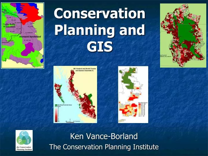
Conservation Planning and GIS. Ken Vance-Borland The Conservation Planning Institute. A Burning Question:. Given that money for biodiversity protection is limited, where should it be invested for maximum benefit?. Conservation planning includes five stages.

E N D
ConservationPlanning andGIS Ken Vance-Borland The Conservation Planning Institute
A Burning Question: Given that money for biodiversity protection is limited, where should it be invested for maximum benefit?
Conservation planning includes five stages • Gathering data on the locations of biodiversity components (species, communities, ecosystems, processes); • Assessing the extent to which biodiversity is represented in existing protected areas; • Identifying additional areas needed for full biodiversity protection; • Implementing protection of those areas; and • Monitoring protected areas to assure persistence of biological diversity over time.Margules and Pressey. 2000. Systematic conservation planning. Nature 405:243-253.
A Conservation Plan for the Klamath-Siskiyou Ecoregion Reed F. Noss, James R. Strittholt, Kenneth Vance-Borland, Carlos Carroll, and Pamela Frost 1999. Natural Areas Journal 19:392-411
The Noss ‘Three-Pronged Approach’: • Special Elements • Coarse-filter habitat representation • Focal species
The Noss ‘Three-Pronged Approach’: • Special Elements • Coarse-filter habitat representation • Focal species
December-July Precipitation Difference Mean Annual Precipitation Mean Annual Temperature July-January Temperature Difference Soil Water-Holding Capacity Soil Depth
Physical Habitat Types High Cool Poor High Cold High Cool High Cool Moist Low Moderate Low Dry Cool Low Warm Low Fertile Low Hot Low Warm Moist High Moist Fertile Low Dry Fertile Low Warm Moist Fertile Coastal Warm Moist Fertile Coastal Cool Moist Coastal Moist Fertile Lowlands Coastal Wet Highlands Coastal Wet Fertile Coastal Rich Lowlands
The Noss ‘Three-Pronged Approach’: • Special Elements • Coarse-filter habitat representation • Focal species
Model Variables • Vegetation size and composition • Roads • Hydrography • Digital elevation, slope, aspect • PRISM mean annual precipitation
Proposed: 80% of public land, 50% of entire region. • Reserve design based on high-priority roadless areas, with other areas included for: • G1/G2 element occurrences • Other element occurrence concentrations • Late-seral forests • Connectivity between roadless areas
A Multicriteria Assessment of the Irreplaceability and Vulnerability of Sites the Greater Yellowstone Ecosystem Reed Noss, Carlos Carroll, Ken Vance-Borland, and George Wuerthner 2002. Conservation Biology 16(4): 895-908
Grizzly bear (Ursus arctos) 1850 1970 Images: Chuck Rumsey, TNC www.grizzlybear.org
Wolf (Canis lupus) Images: Nova Online U.S. Fish and Wildlife Service
Wolverine (Gulo gulo) Gerald and Buff Corsi
Elk (Cervus elaphus) Rocky Mountain Elk Foundation
Variables for: *MODIS July brightness and Greenness; November brightness, greenness and wetness *Slope *Elk winter range *Road density *Management class (private, general public, wilderness, or park) *And interactions between road density and management class and between November brightness and wetness.
Fine Filter EmphasisSpecial elements: 90-100% Biophysical habitats: 15-25%Focal species: 30-50% Coarse Filter EmphasisSpecial elements: 50-100% Biophysical habitats: 35-50%Focal species: 30-50% Focal Species EmphasisSpecial elements: 50-100% Biophysical habitats: 15-25%Focal species: 50-75%
Great Sand Hills Regional Environmental Study Saskatchewan Ministry of Environment, U. of Regina, U. of Central Florida, U. of Saskatchewan, the Conservation Planning Institute, and others
Roads Gas well pads Cattle watering holes) 1244 in study area 398 in study area
Landcover (grassland) strata Disturbed Juniper Shrubby Herbaceous Water holes 10 i + 10 c 10 i + 10 c 10 i + 10 c 10 i + 10 c 40 i + 40 c Gas pads 10 i + 10 c 10 i + 10 c 10 i + 10 c 10 i + 10 c 40 i + 40 c Impact strata 40 i + 40 c 10 i + 10 c 10 i + 10 c 10 i + 10 c 10 i + 10 c Roads Totals 30 i + 30 c 30 i + 30 c 30 i + 30 c 30 i + 30 c 120 + 120 i = impact (case) site, c = control (distant from impact) site
Species models from the 2006 field data Rare & Medicinal Plants: 15. Beaked annual skeleton-weed 16. Chokecherry 17. Low milk vetch 18. Prairie moonwort 19. Six-weeks fescue 20. Small lupine 21. Smooth arid goosefoot 22. Windflower Exotic Plants: 23. Canada thistle 24. Crested wheat 25. Kentucky bluegrass 26. Smooth brome Birds and mammals: 1. Baird’s sparrow 2. Brown-headed cowbird 3. Chestnut-collard longspur 4. Clay-colored sparrow 5. Common nighthawk 6. Grasshopper sparrow 7. Horned lark 8. Long-billed curlew 9. Marbled godwit 10. Ord’s kangaroo rat 11. Savanna sparrow 12. Spotted towhee 13. Sprague’s pipit 14. Upland sandpiper 27. Range health
Roads and RAER were used to classify the GSH: • 1.88 km/km2 (mean [1.54] + ½ standard deviation) used to divide the GSH into 2 zones (min size 9-sq mi): • ‘highly’ developed zone (≥1.88 km/km2) • ‘less’ developed zone (< 1.88 km/km2) RAER 1.2 km/km2 roads Road density: Highly developed Less developed
Exploring a range of goals with Marxan 65% 50% 40% 30% 20%
Epilogue Our proposal Minister’s recommendation 30% 60%
“The biodiversity planning component should be integrated into an implementation framework and not vice versa” Cowling and Pressey 2003, Biological Conservation 112:1-13
Concluding thoughts • Approaches to answering ‘the burning question’ are constantly evolving • Frontiers in conservation science and planning include: • Freshwater conservation • Integrated land-freshwater-sea analysis and planning • Ecosystem services valuation and downstream cost/benefit sharing • Climate change • Limits to growth • Implementation: the knowing-doing gap
Burning Questions? Ken Vance-Borland The Conservation Planning Institute Corvallis, Oregon kenvb@consplan.net www.conservationplanninginstitute.org