Download
1 / 16
190 likes | 525 Views
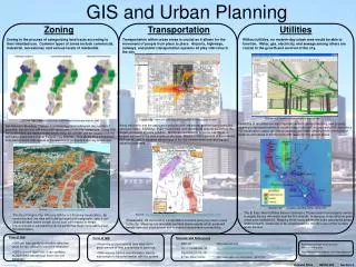
GIS and Transportation Planning. GIS and Transportation Planning. Contents Transportation Planning ~ Introduction Five Key Components of Transportation Planning Main Transportation Planning issues Role of GIS in Transportation Planning a brief Case Study Introduction to TrsansCAD

E N D
GIS and Transportation Planning Contents • Transportation Planning ~ Introduction • Five Key Components of Transportation Planning • Main Transportation Planning issues • Role of GIS in Transportation Planning a brief Case Study • Introduction to TrsansCAD • Conclusion
Transportation Planning • To identify , evaluate and select Transportation options for future efficient and safe movement of people and goods • Minor corner development to international highway network • A few weeks to a few decades
Five Key Components of Transportation Planning • Land use • Trip Generation • Mode Choice • Trip Distribution • Trip Assignment
Main Transportation Planning issues • What level of congestion is acceptable and affordable? • What improvements to the region’s public transportation system are needed? • How to prioritize the investment of limited transportation dollars to meet the needs of motorists, pedestrians, transit riders, bicyclists and businesses?
Case Study , Portland Metro Oregon ~ GIS in Transportation Planning • How best to serve the region’s growing population, forecast to increase to 1.56 million by 2015 • Compliance with the state Transportation Planning Rule, which requires metropolitan areas to reduce reliance on the car and reduce vehicle miles of travel per capita (VMT) during the next 20 to 30 years • Improving accessibility to employment, education and non-work activities in a situation where traffic congestion is expected to get worse during the plan period
Case Study , Portland Metro Oregon ~ GIS in Transportation Planning Transportation Alternatives Analysis Motor Vehicle Alternatives: • Vary levels of investment in roadway improvements • Moderate level of investment in public Transport Transit and Pedestrian Alternatives: • Vary levels of investment in transit and pedestrian access to transit • Moderate levels of investment in roadway improvements for autos, trucks and bicycles
Case Study , Portland Metro Oregon ~ GIS in Transportation Planning • Metro determined that it needed to build a sophisticated travel demand forecasting model that predicts how each alternative would affect transit ridership, traffic congestion, access to jobs, movement of goods and many other factors. • Geographic Information System (GIS) was used to collate and manage the data needed for the transportation model. The GIS was also used to display the model outputs, such as predicted employment densities, pedestrian environment factor and VMT.
Case Study , Portland Metro Oregon ~ GIS in Transportation Planning • Geocoding of survey data: household and activity locations, including employment sites, non-work activity centers and transit access locations. • Analysis of demographic characteristics such as distribution of income, household size and age of household head. • Analysis of total and retail employment.
Case Study , Portland Metro Oregon ~ GIS in Transportation Planning • Analysis of residential and industrial acres (mixed land-use) • Analysis of pedestrian accessibility to transit services and of zonal accessibility by different modes • Data aggregation to TAZ • Mapping and display of model outputs, including results of traffic and transit network assignments
Case Study , Portland Metro Oregon ~ GIS in Transportation Planning Benefits Using GIS • GIS enhances capabilities of travel forecasting models • GIS manages data inputs to and outputs from transportation model • Consistent means to collect and organize information for validation, analysis, and dissemination • Helps to support centralized Regional Data Center that acts as a clearing-house and repository for multiple jurisdictions • Allows easier transfer of data between jurisdictions • GIS makes the model results more accessible and easier to interpret by wider range of users and policy-makers
Case Study , Portland Metro Oregon ~ GIS in Transportation Planning Lessons Learned • GIS expands transportation model analysis capabilities. • Desktop applications (such as ArcGIS) are becoming more prevalent for GIS based analysis. These applications are generally easier to use and available to a broader base of transportation analysis. • GIS is best used to support model data inputs and display of outputs rather than modeling itself. • GIS system takes time to develop and require agency commitment to ensure adequate maintenance and usability. • GIS was justified in part by modeling needs to develop enhanced procedures to meet agency goals and mandates, i.e. GIS not an option but a core technology for City Council’s business
TransCAD • TransCAD is the first and only Geographic Information System (GIS) designed specifically for use by transportation professionals to store, display, manage, and analyze transportation data. • TransCAD combines GIS and transportation modeling capabilities in a single integrated platform. TransCAD can be used for all modes of transportation, at any scale or level of detail. TransCAD provides: • A powerful GIS engine with special extensions for transportation • Mapping, visualization, and analysis tools designed for transportation applications • Application modules for routing, travel demand forecasting, public transit, logistics, site location, and territory management
Conclusion • GIS is the best methodology for communicating the meaning of spatial data • Virtually eliminates the need to trudge through large spreadsheets and data base information • Displays your data quickly in picture format • Communicate the meaning of complex data efficiently • A picture is worth a thousand words • GIS is an excellent tool for developing performance measures • Zoom in or out to the level of detail that any transportation planning project requires