Download
1 / 27
270 likes | 358 Views
Overview of soil data at European scales. F. Carré & T. Mayr. Need to distinguish…. EU Commission. EU Commission data. 25 EU Member States data. EU Commission data. 3 kinds of data. Vector map data (scale is important). Raster data (resolution is important).

E N D
Overview of soil data at European scales F. Carré & T. Mayr
Need to distinguish… EU Commission EU Commission data 25 EU Member States data
3 kinds of data Vector map data (scale is important) Raster data (resolution is important) Profile measurement & estimates
3 kinds of data Vector map data (scale is important) Raster data (resolution is important) Profile measurement & estimates
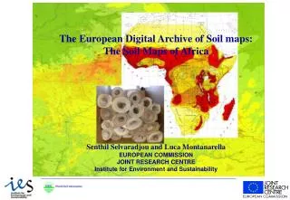
Vector data Eurasian soil data at 1:1M scale
Updated in the SINFO context Attributes attached to STU Contains 73 attributes Extrapolated/ generalized Texture (according to FAO) Land use Parent material Dominant limitation to agricultural use STU name (WRB 98, FAO 90…) Obstacle depth for root OC of topsoil, CEC, BS… derived from PTF Crusting Erodibility AWC Topsoil packing density…
Parameters and Pedotransfer Functions Mualem-van Genuchten parameters fitting on the geometric mean curves Attributes attached to STU Parameters and Pedotransfer Functions Mualem-van Genuchten parameters fitting on the geometric mean curves * Within the organic soils no distinction is made in topsoils and subsoils
Vector data Ground Water Resources Produce data from digitizing European-wide ground water maps, resulting from a study by EU Catalogue national water resources for 12 Member States of the European Union
Vector data Delineation of watersheds Under FP6 CCM developed a first version of a European-wide river and catchment database for future use in environmental modeling activities. The database corresponds to a mapping scale of roughly 1:250 000 to 1:500,000, depending on the region.
3 kinds of data Vector map data (scale is important) Raster data (resolution is important) Profile measurement & estimates
Raster data PESERA: Pan-European Soil Erosion Estimation Risk Assessment Soil erosion estimates (t/ha/yr) by applying the PESERA GRID model at 1km x 1km New version redone by Salvaradjou from DSM techniques
Raster data • Organic Carbon Content on Topsoils 0-30cm • The data are in GRID format and are available as ASCII raster file or in native ESRI GRID format (1km x 1km) • Done by PTF (Jones et al., 2004)
Raster data Eurasian soil database at 1 km*1km resolution
Other raster data related to soil issues Corine Land Cover 2000 • GRID format in native ESRI GRID format (25 m x 25 m) • Description of 44 classes (mostly urban) SRTM 90 m vs3 (Void filling corrected) …
3 kinds of data Vector map data (scale is important) Raster data (resolution is important) Profile measurement & estimates
Profiles & measurements DanubeSIS - Soil Information System on the Danube River Objectives: Collection of Soil Point Data in the Danube River Provide the data to Flood Risk Assessment Results: 1200 points per country: CZ, AUT, BA, ROM, SK, HU, … Data / hrz: granulometry, Soil type name, Hrz depth, OM class, humus type, obstacle to roots…
Profiles & measurements SPADE_M: Soil profiles of Europe (146 profiles) Measured par. of the representative profiles of EuSIS STU Texture (& particle size grades) Organic matter content (C, N) Structure Total nitrogen content pH ESP or SAR Calcium carbonate content Calcium sulphate content Electric conductivity CEC and exchangeable bases Soil water retention Bulk density Root depth Groundwater level Parent material
Profiles & measurements SPADE_M (from Forest Focus database) Level I (mandatory at 16 km * 16 km) and Level II data (acc. to MS) 4560 profiles in Forest Soils at Level I Sampled at 5 depths Physical soil parameter Organic layer Coarse fragments Bulk density of the fine earth Particle size distribution Clay content Silt content Sand content Chemical soil parameter pH(CaCl2) Organic carbon Total nitrogen Carbonates Aqua regia extracted P, Ca, K, Mg, Mn Aqua Regia extracted Cu, Pb, Cd, Zn Aqua Regia extracted Al, Fe, Cr, Ni, S, Hg, Na Exchangeable acidity Exchangeable cations Ca, mg, K, Na, Al, Fe, Mn, H pH(H2O) Total elements Ca, Mg, Na, K, al, Fe, Mn Oxalate extractable Fe, Al
Profiles & measurements LUCAS (Land Use/Cover Area frame Survey) 250.000 points in 2005 Deals with: Very detailed land use classes Erosion Natural hazards Now: soil texture…
A lot of data but not too much measurements A lot of estimated data by PTFs For the moment, there is no harmonization of measured data. This will come from Biosoil study (measurements will be finished in August 2008) but it represents only 10% of the whole plots