Download
1 / 29
310 likes | 584 Views
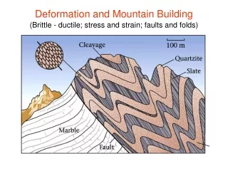
Fine Deformation Monitoring of Ancient Building based on Terrestrial Laser Scanning Technologies. Zhou Wei Key Laboratory of Digital Earth, Institute of Remote Sensing and Digital Earth (RADI), Chinese Academy of Sciences;

E N D
Fine Deformation Monitoring of Ancient Building based on Terrestrial Laser Scanning Technologies Zhou Wei Key Laboratory of Digital Earth, Institute of Remote Sensing and Digital Earth (RADI), Chinese Academy of Sciences; International Centre on Space Technologies for Natural and Cultural Heritage (HIST), under the Auspices of UNESCO 23 April 2013
Outline • Introduction • Data Acquisition & Processing • Deformation Monitoring • 3-Dimensional Modeling • 3D Information Management System
Research Background Natural Influence Global Change (Greenhouse Effect) Geohazards (Earthquake) Meteorological Disasters (Storm) World Heritage Forest Disasters (Forest Fire) Floods & Ocean Disasters (Tsunamis) …… Impact on Human Induced Resource over-exploitation Deformation Land encroachment Pollution Solution Uncontrolled Tourism ……
General Objective Documentation Restoration Publicity Fine Mapping & Historical Info Smart Management Monitoring & Analyzing Preventative Protection Evaluation & Early Warning Space Technologies play an important role in the sustainable development of world heritage!
Experimental Site – World Cultural Heritage The Summer Palace, located in a northwestern suburb of Beijing, first built in 1750, largely destroyed in the war of 1860 and restored on its original foundations in 1886 – is a masterpiece of Chinese landscape garden design. It is also presently the best-preserved imperial garden. It was inscripted in the World Heritage List in 1998. Longevity Hill Tower of Buddhist Inscense Kunming Lake South Island West Lake 17-Arch Bridge South Lake Quickbird Imagery of the Summer Palace Acquired on 22 Mar 2009
the Tower of Buddhist Incense As the symbol of the Summer Palace, the Tower of Buddhist Incense represents the highest achievement of traditional Chinese architectural art. The octagonal, three-storied and quadruple-eaveswood-constructed tower is built on a 20-metre-high granite platform with the Longevity Hill in the north and the Kunming Lake in the south. There’re eight solid lignumvitaecolumns served as pillars supporting the 36.47-metre-high tower.
Threats to the Tower Due to disrepair, natural disasters, climate change and human activities, the tower is facing great threats. wooden pillars damaged by the pests Threaten the Integrity! roof ridge animals glazed roof tiles Ironstand added to the ancient building Threaten the Authenticity!
Outline • Introduction • Data Acquisition & Processing • Deformation Monitoring • 3-Dimensional Modeling • 3D Information Management System
Terrestrial Laser Scanning Apparatus Handheld 3D Scanner obtain close-range data obtain data of single cultural relic or areas cannot reached by the above two scanners Z+F IMAGER 5006i obtain relative long-range data LeicaScanStation C10
Data Acquisition by Laser Scanning 1st storey 2nd storeyon the scaffold and indoor Long-range scanning for the whole tower 3rd storeyand the interlayer above it
Point Clouds Registration Due to complicated objects overlapping caused by observing from different points of view and the geometric characteristics of the object itself, it’s hard to obtain complete information of a certain target just from one scan station. The solution is to use the same group of artificial targets which are placed in the scene and measured from each of the overlapping scan stations. registration result of the 1st storey indoor point clouds of the 1st storey white points are the artificial targets
Point Clouds Registration In order to improving the registration precision, 92 scan stations were set up for data acquisition. Moreover, some more artificial targets are placed to increase redundant observations. The registration error of point cloud data is less than 5 millimetres. registration result of the 3 stories registration result of the whole tower and its surroundings
Produce CAD Drawings we get many cross-sections in each storey, and then each cross-sections can outline structural feature of building. the slices of point clouds CAD drawings
Produce CAD drawings The elevations of the Tower of Buddhist Incense The sections of the Tower of Buddhist Incense
Outline • Introduction • Data Acquisition & Processing • Deformation Monitoring • 3-Dimensional Modeling • 3D Information Management System
Estimate Dip & Dip Direction Cross-Section of the Pillars In order to estimate the dip and dip direction of every pillar, we get the cross-sections from the top and the bottom part of the pillar segment in each storey, and then eight cross-sections can be obtained from one integral pillar including the pillar segment inside the double eaves above the third storey. cross sections of the pillars’ bottom in each story
Estimate Dip & Dip Direction The tower has a slight inclination towards the southeast, and the dip angle is around 0.7 degree. the dip and dip direction of every pillar can be worked out by connecting the centre points of each pillar Dip angle of the Pillars dip direction of the Pillars
Outline • Introduction • Data Acquisition & Processing • Deformation Monitoring • 3-Dimensional Modeling • 3D Information Management System
3D Modeling The Tower of Buddhist Incense has been repaired every few years. Pre-maintenance Under repair After-maintenance we must record the status quo and history information elaborately and comprehensively. Laser scanning technologies are applied to 3D model building of the tower, and the detail property of the tower components can be recorded based on 3D models.
3D Modeling Roof ridge animal scanned by handheld 3D scanners the lion's model the model of eaves Eaves scanned by Z+F laser scanners
3D Modeling texture capture & point clouds of paintings in the 3rd storey 3d model of the paintings model of the xumisupport point clouds capture of the xumisupport
Outline • Introduction • Data Acquisition & Processing • Deformation Monitoring • 3-Dimensional Modeling • 3D Information Management System
3D Information Management System It turns out that building the database of 3D models and picture archiveshelp to preserve the original data of cultural heritage, including the spatial relationship information and other important types of data.
3D Information Management System The tower has a complicated structure, so the 3D models of the tower are divided into three stories to manage, and the same kind of components is put in a category in a single storey.
3D Information Management System dialog box of component maintenance information maintenance time maintenance organization maintenance record
3D Information Management System dialog box of component maintenance information shooting time of photo of the tower components Pre-maintenance Under repair After-maintenance
Video Display Finally