Download
1 / 7
170 likes | 373 Views
We have been carrying out 3D laser scanning survey & cloud burst services in the UK for over 15 years, and were one of the very first laser scanning companies in the UK to purchase a laser scanner. Visit Scantech International now to know more. #laserscanningsurveying #topographicalsurveyuk #3dlaserscanningservices #pointcloudsurvey #laserscanningcompanies Source: https://scantech-international.com/3d-laser-scanning-services<br>https://medium.com/@scantechinternational10/laser-scanning-surveying-3d-laser-scanning-services-3d6926fde86c

E N D
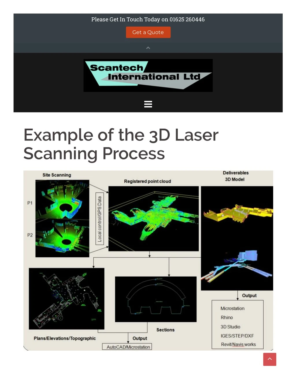
Please Get In Touch Today on 01625 260446 Get a Quote Example of the 3D Laser Scanning Process
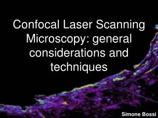
3D LASER SCANNING - WHAT IS IT ? 3D Laser Scanning is a non-contact, non-destructive technology that digitally captures the shape and dimensions of physical structures and objects using a line of sight laser light. Laser scanning uses a very rapid laser beam of up to 1 million points per second to scan the environment and capture a vast quantity of data from the surface of structures and objects in the form of a pointcloud, where each point has it’s own xyz coordinate. In other words a 3D laser scanning survey or Cloud Burst Survey is a way to capture a structure or objects exact size and shape and represent this in the computer world as a digital 3-dimensional model. 3D laser scanners measure fine details and capture free-form shapes to quickly generate highly accurate point clouds. A 3D laser scanning survey is ideally suited to the measurement and inspection of contoured surfaces and complex geometries which require massive amounts of data for their accurate description and where doing this is impractical with the use of traditional measurement methods. Scantech International and our 3D Laser Scanning Services Here at Scantech International Ltd we have been carrying out 3D laser scanning or cloud burst services in the UK for over 15 years, and were one of the very first laser scanning companies in the UK to purchase a laser scanner. High De?nition 3D Laser Scanning or Cloud Burst Applications Historical Preservation Detailed Measurements Surveying hard-to-reach areas Construction Progress Digital 3D Photos Video of Surveys MP3 and JPG Files Changes view to real-time 3D Record exact data Uses of the 3D Laser Scanning Technology: Volumetric Measurements - Laser Scanning surveying is ideal for calculating volumes of for example coal mounds or cuttings and can quickly determine the volume using specialist so?ware and we have many examples of where we have used this application
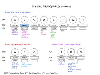
Void Inspections - Using a specialist laser scanner we can insert the probe into a void via a drilled borehole and produce a point cloud of the interior. This can be used to calculate the void volume as well as generating cross-sections and various measurements. As-built Models and Drawings - Depending on our clients requirements, we can produce both BIM models and 3D CAD models and drawings accurate to 5mm throughout from a Point Cloud Survey Mechanical, Electrical and Plumbing (MEP) as-built Models and Drawings - Using our 3D scanning services to produce the as- built 3D point cloud of a building prior to fit out allows the designers of the MEP services to modify their design to avoid clashes and rework with structures that di?er in location from their design locations. Change detection - Di?erences between the design of a structure/building and the as-constructed structure/building can easily be highlighted by undertaking a 3D laser scanning survey and comparing the BIM design model with the resulting point cloud Clash Detection - See Mechanical, Electrical and Plumbing (MEP) as-built Models and Drawings above Structural as-built Models and Drawings - We have undertaken hundreds of 3D surveys of buildings, bridges and tunnels using high resolution 3D scanning to produce accurate BIM and CAD models as well as 2D drawings (elevations, sections, etc.) Catastrophic event mapping Hazard surveying Accident reconstruction Registered photo video coordinates Laser Scanners We Use: To carry out our 3D Scanning Services we us the following 3D laser scanners to capture our point cloud data. Leica HDS P20 for outdoor and intermediate distance scanning Faro X330 for indoor measured building type surveys Riegl 390i for long distance scanning up to 300m Faro Freestyle for areas that are di?icult to access C-ALS for void inspections Software Tools Revit AutoCAD 3DS Max Navisworks ReCap Pointools Microstation Leica Cyclone LFM Solidworks ClearRoute Rhino Laser Scanning Companies UK
In 2002 Scantech International Ltd was one of the first laser scanning companies to be established. We have carried out 3D laser scanning surveys and services throughout the UK, Europe and as far as the Middle East. In the UK we have carried out these surveys in all the major cities including : Laser scanning London Laser scanning Birmingham Laser scanning Manchester Laser scanning Leeds laser scanning Newcastle Laser scanning Bristol Laser scanning Wolverhampton Laser scanning Liverpool Laser scanning York Laser scanning Ipswich Laser scanning Glasgow Laser scanning Edinburgh Laser scanning Aberdeen Our turnaround time from a one-day survey on site to producing the deliverables varies from 2-3 days for a simple registered point cloud, drawing or 3D model to up to 10 days for a complex high specification (ie detailed features) BIM model. If you are looking for a specialist laser scanning company in the UK then please get in touch via our contact page and we can provide you with a quote, proposal or any additional information you may require. If You're after a quote, chat or anything else please get in touch CONTACT US 3D LASER SCANNING CASE STUDIES Twickenham Stadium - 3D Pointcloud Survey | Kings College London - 3D Pointcloud Survey | BIM Model Harringworth Viaduct - 3D Pointcloud Survey | Wireframe Model | Topographical | Colourised Pointcloud Manchester Victoria Station - | 3D Pointcloud Survey 3D L i
3D Laser scanning CLIENTS REVIEWS “We would like to thank you for your e?orts delivering the topographic survey and 3D pointcloud survey for the 82 span, 1200m long Harringworth Viaduct recently.To complete the works for such a structure in the limited time available in the possessions was fantastic. We also appreciate your flexibility in rescheduling the works at short notice due to problems with the possession booking.We are now creating the elevations and sections for the viaduct and would like to thank you for the quality of your deliverables and your availability for ongoing discussions with our CAD team.” “Morgan S a multi d Victoria Lin series o The qua Client, D infrastruc Martyn Roome Associate - COWI/Donaldson Associates
FOLLOW US ON SOCIAL MEDIA FOR PROMOTIONS, NEWS & EXCITING PROJECTS CONTACT US 01625 260446 keith.mccrory@scantech-international.com ScanTech International Ltd is a limited Company registered in England and Wales with Company No. 4370185 and VAT No 784028320 and does not accept legal responsibility for the contents of this Website. The viewer is responsible for verifying its authenticity before acting on the contents. Registered O?ice : Hillside, 2 Murrayfield, Prestbury, Cheshire SK10 4BZ Sitemap Home Sectors Railway Surveys Railway Gauging Tunnel Condition Evaluation and Monitoring BIM Surveys Process Plant Surveys Highway Surveys Heritage Drone Surveying Train Model
Land Surveys Point Cloud Survey Services 3D Laser Scanning services BIM Modelling Topographical Surveys Setting-out Measured Building Surveys Asset Management and 3D Laser Scanning Elevation Survey Engineering Surveys Case Studies CS – Harringworth Viaduct CS – Manchester Victoria Station CS – Twickenham Stadium CS – Kings College London CS – Lordhope CS – Waste Water Treatment Works My blog Contact Us Proudly powered by WordPress | Theme: Sydney by aThemes.