Download
1 / 1
10 likes | 91 Views
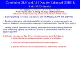
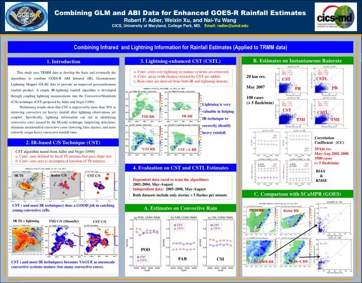
Combining GLM and ABI Data for Enhanced GOES-R Rainfall Estimates Robert F. Adler, Weixin Xu, and Nai-Yu Wang CICS, University of Maryland, College Park, MD. Email: radler@umd.edu. Combining Infrared and Lightning Information for Rainfall Estimates (Applied to TRMM data) .

E N D
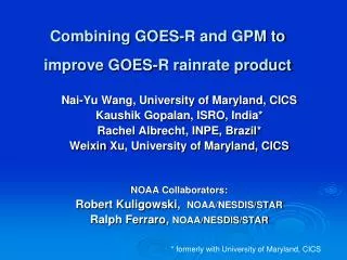
Combining GLM and ABI Data for Enhanced GOES-R Rainfall Estimates Robert F. Adler, Weixin Xu, and Nai-Yu WangCICS, University of Maryland, College Park, MD. Email: radler@umd.edu Combining Infrared and Lightning Information for Rainfall Estimates (Applied to TRMM data) B. Estimates on Instantaneous Rainrate 3. Lightning-enhanced CST (CSTL) 1. Introduction This study uses TRMM data to develop the basis and eventually the algorithms to combine GOES-R ABI Infrared (IR), Geostationary Lightning Mapper (GLM) data to provide an improved geosynchronous rainfall product. A simple IR-lightning rainfall algorithm is developed through coupling lightning measurements into the Convective/Stratiform (C/S) technique (CST) proposed by Adler and Negri (1988). Preliminary results show that CST is improved by more than 30% in retrieving convective (or heavy) rainfall after lightning observations are coupled. Specifically, lightning information can aid in identifying convective cores missed by the IR-only technique (improving detection), eliminate misidentified convective cores (lowering false alarms), and more correctly assign heavy convective rainfall rates. a. Conv. cores w/o lightning in mature systems are removed; b. Conv. areas (with flashes) missed by CST are added; c. Rain rates are derived from both IR and lightning density; 20 km res. May 2007 100 cases (> 5 flash/min) CSTL CST PR PR Lightning is very valuable in helping IR technique to correctly identify heavy rainfall. CST CSTL PR RR TMI RR TMI TMI Correlation Coefficient (CC) 2. IR-based C/S Technique (CST) 20 km res. May-Aug 2002-2008 3500 cases (> 5 flash/min) CST RR CST + L RR CST algorithm tuned from Adler and Negri (1988) a. Conv. core defined by local Tb minima that pass slope test; b. Conv. core area is an empirical function of Tb minima. 4. Evaluation on CST and CSTL Estimates BIAS & RMSE Radar C/S IR Tb CST C/S Dependent data (used to train the algorithm): 2002-2004, May-August Independent data: 2005-2008, May-August Both datasets include only storms > 5 flashes per minute C. Comparison with SCaMPR (GOES) CST ( and most IR techniques) does a GOOD job in catching young convective cells. A. Estimates on Convective Rain PWM RR Radar RR IR Tb + lightning TMI C/S (10mm/hr) CST C/S POD FAR CSI IR+L RR CST ( and most IR techniques) becomes VAGUE as mesoscale convective systems mature (too many convective cores). SCaMPR RR