Download
1 / 37
370 likes | 378 Views
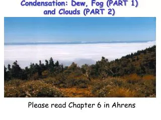
Chapter 5 Condensation: Dew, Fog and Clouds. Dew/Frozen Dew. Clear calm night Objects close to the ground cool rapidly by emitting ____ radiation ground and objects become colder than surrounding air air in contact with these surfaces cools by conduction

E N D
Chapter 5 Condensation: Dew, Fog and Clouds
Dew/Frozen Dew • Clear calm night • Objects close to the ground cool rapidly by emitting ____ radiation • ground and objects become colder than surrounding air • air in contact with these surfaces cools by conduction • given enough time, air will cool to the Dew point • water then condenses to the cold surfaces • dew will freeze if temperature drops below freezing
Frost • Formation similar to dew or frozen dew • Dew point starts out below freezing (frost point) • water vapor changes directly to ice without becoming a liquid • Deposition occurs
Formation of Dew & Frost As air cools to its saturation, or dew point, vapor molecules slow down and can adhere as dew on the ground surface or as frost when air temperature drops below freezing. Daily temperature lows often occur by radiational cooling, forming dew at night or early morning.
Condensation Nuclei • Must be airborne particles on which water vapor can condense to produce cloud droplets • although air looks clean, it never truly is • a volume of air (about the size of an index finger) contains between 1,000 and 150,000 particles • many of these particles serve as condensation nuclei • small condensation nuclei (<0.2micrometer) - Aitken Nuclei • larger condensation nuclei (0.2 - 1.0 micrometer) are called giant nuclei • condensation nuclei most favorable for producing clouds (>1.0 micrometer) are called cloud condensation nuclei (CCN)
Condensation Nuclei (cont.) • usually between 100 - 1000 CCN exist in a cubic centimeter of air • these particles come from… dust, volcanoes, smoke, salt, sulfate particles emitted by phytoplankton • condensation can occur when RH is lower than 100% • these particles are called hygroscopic (water-seeking) • Salt is the most common hygroscopic particle
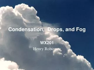
Fog • air close to the ground becomes saturated • millions of CCN present to form a cloud • fog over cities usually more dense than fog over the ocean • fog is formed in two ways • - by cooling (air is cooled to its dew point) • - by evaporation and mixing
Radiation Fog • fog produced by the earth’s radiational cooling • sometimes called ground fog • forms best on clear night when a shallow layer of moist air is below a larger layer of dry air • the shallow layer does not absorb much of the outgoing IR radiation from the surface • the ground, therefore, cools very rapidly • the air above the layer also cools very rapidly and a surface inversion forms • the moist layer is chilled by the cold surface and becomes saturated
Ground Based Radiation Fog Fog is condensed vapor droplets at a density that severely restricts visibility. It may form by radiation fog, which occurs at the ground when dew point temperature is reached by radiational cooling.
Advection Fog • surface air is cooled my moving warm moist air over a cold surface • example: Pacific coast during summer • - surface water near the coast is much colder than surface water offshore • - warm, moist air from the Pacific Ocean is carried by westerly winds over the cold, coastal waters • also forms over land • - warm, moist air from the Gulf of Mexico moves Northward over colder, elevated land • - this fog is called advection-radiation fog
Advection Fog Warm moist air that moves, or advects, above a cold surface may become cooled to its dew point temperature, creating an advection fog. This fog often forms above the ocean due to mixing currents, or when warm ocean air rolls into the cooler waters at the Pacific Coastline.
Other kinds of fog Upslope fog - moist air flows up along an elevated plain, hill, or mountain Evaporation fog - mixing warm unsaturated air with cool unsaturated air from evaporation Hail fog
Evaporation or Mixing Fog Fog can form by mixing warm unsaturated air with cool unsaturated air, which can occur during evaporation. Steam fog is on example of this mixing process and occurs when warm pools of water are a source for vapor that condense into the cooler air above.
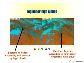
Fog & Human Safety Foggy days in the US have a predictable distribution due to ocean and mountain influences. Fog can help crop growth in California, but can also cause severe automobile, airplane, and boating accidents. As a result, there are several fog dispersal experiments. Figure 6.8
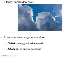
Clouds • Clouds are water droplets (or ice crystals) suspended in the atmosphere • clouds are grouped by their elevations as high (20-60kft), middle(6500-26,000ft), and low (sfc - 6500ft), as well as those that stretch (vertically) across many altitudes • these 4 groups contain several cloud types
Cirrus Clouds High clouds (above 6000 m in middle latitudes) that are thin and wispy and comprised mostly of ice crystals.
Stratus Clouds Low clouds that resembles a fog, but does not reach the ground, and can generate a light mist or drizzle.
Cumulus Clouds Clouds with vertical development that take a variety of shapes, separated by sinking air and blue sky. Shredded sections are called cumulus fractus.
Cirrocumulus Clouds High clouds that are rounded puffs, possibly in rows, are less common than cirrus.
Cirrostratus Clouds High clouds that thinly cover the entire sky with ice crystals. Light passing through these crystals may form a halo.
Altocumulus Clouds Middle clouds (between 2000 and 7000m in middle latitudes) that are puffy masses of white with gray edges. With your hand overhead, they are about the size of your fingernail.
Altostratus Clouds Middle clouds that cover the entire sky and may create a dimly visible or watery sun and diminish formation of shadows.
Nimbostratus Cloud Low clouds (below 2000m) with precipitation that reaches the ground. Shredded parts of these clouds are called stratus fractus or scud.
Stratocumulus Clouds Low clouds with rounded patches that range in color from light to dark gray. With your hand extended overhead, they are about the size of your palm.
Cumulus Congestus Clouds Clouds with vertical development that become larger in height, with tops taking a ragged shape similar to cauliflower.
Cumulonimbus Cloud Clouds with vertical development that have grown into a towering thunderstorm cloud with a variety of key features, including the anvil top.
Lenticular Clouds An unusual cloud that has a lens shape and forms in the crest of a wave.
Banner “Cap” Cloud A lenticular cloud that forms downwind of a mountain peak and is regularly replenished by condensing water vapor.
Pileus Cloud An unusual cloud that forms above a building cumulus by deflected moist winds.
Mammatus Clouds An unusual cloud that hang like sacks, formed by sinking air with a high water content.
Jet Contrails Jet engine exhaust provides vapor and nuclei for condensation trails (contrails), which evaporate quickly in dry air, but linger with higher relative humidities.
Nacreous Clouds An unusual cloud best viewed at winter in the poles and forms in the stratosphere.
Noctilucent Clouds An unusual wavy cloud that is best viewed at the poles and forms in the upper mesosphere.