Download
1 / 45
480 likes | 839 Views
Condensation: Dew, Fog, and Clouds. This chapter discusses: 1. How dew, frost, haze, fog, and clouds form from atmospheric moisture 2. Classification of fog and cloud types from observation. Formation of Dew & Frost.

E N D
Condensation: Dew, Fog, and Clouds This chapter discusses: 1. How dew, frost, haze, fog, and clouds form from atmospheric moisture 2. Classification of fog and cloud types from observation
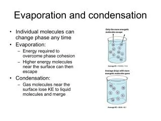
Formation of Dew & Frost • As air cools to its saturation, or dew point, vapor molecules slow down and can adhere as dew on surfaces or as frost when air temperature drops below freezing. • Daily temperature lows often occur by radiational cooling, forming dew or frost at night or early morning. • Condensation can occur when RH < 100% when condensation nuclei are present in the atmosphere.
Condensation Nuclei • Condensation Nuclei (CN) help to condensate water vapors quicker than just plain water vapors by itself. • It would takes about 108 – 114 % of RH to form a cloud droplet from homogeneous nucleation (water vapor by itself) due water surface tension. • With heterogeneous nucleation (condensation with CNs), RH value can be lower than 100% to form a cloud droplet • Aerosols will dissolve in water and weaken the surface tension promoting condensation.
Aerosols • Continental • Dust, SO2, (NH4)2SO4 Ammonium Sulfate, Combustion products, Pollens • These CNs are mechanically transported into the atmosphere • Marine • NaCl • From ocean spray • Extraterrestrial • Meteoritic dust • Cloud Condensation Nuclei (CCN) • Enhances formation of cloud droplets • Ice Nuclei (IN) • Promotes formation of ice crystals; geometry makes for good IN (six sided) • More rare in the atmosphere • Hygroscopic • Attracts WV molecules to their surface • NaCl; (NH4)2SO4 • Hydrophobic • Resistant to WV • Oil, gasoline, wax, etc.
Density of aerosols in different environments • Pristine Environments & Open Ocean • 102 cm-3 • Rural (clean) Areas • 102 - 103 cm-3 • Suburban locations (i.e. Castle Rock) • 102 - 104 cm-3 • Towns/Cities • 104 - 105 cm-3 • Large Cities • 106 cm-3
Haze & Water Seeking Nuclei • Above the ground surface as cooling occurs, the speed of the water vapor molecules slows down thereby condensing upon condensation nuclei. • Hygroscopic particles such as salt or dust seek condensing vapor, and can form a wet white haze when relative humidity is above 75%, or a dry blue haze when drier.
Ground Based Radiation Fog • Fog is condensed vapor droplets at a density that severely restricts visibility. • It may form by radiation fog, which occurs at the ground when dew point temperature is reached by radiational cooling. • Acid fog threatens humans health because the droplets are combined with gaseous pollutants.
Advection Fog • Warm moist air that moves, or advects, over a cold surface may become cooled to its dew point temperature, creating an advection fog. • This fog often forms above the ocean due to mixing currents, or when warm ocean air rolls into the cooler waters along the the Pacific Coastline.
Condensation & Moisture Sources Fog that is filtered by tree branches, or condensation of vapor directly onto vegetation or the ground surface, provides an important water source for ecological processes and hydrological cycle.
Upslope Fog • Forms as a result of moist air flowing up along an elevated plain, hill or mountain. • Typically forms during the winter and spring on the eastern slope of the Rockies. • Can last for several days covering an extensive area.
Evaporation or Mixing Fog • Fog can form by mixing warm unsaturated air with cool unsaturated air, which can occur during evaporation. • Steam fog is an example of this mixing process and occurs when a warm pool of water is the source for vapors that condense into the cooler air above.
T = -10 °C Td = -15°C W = 1.2 g/kg Parcel B; RH = 67% 1 kg T = 20 °C Td = 15°C W = 10.8 g/kg Parcel A; RH = 72% 1 kg Mixing New Mixed Parcel 2 kg • The mixed parcel actually vapor content exceeds the amount the parcel can hold hence “supersaturation” occurs. • At supersaturation, WVs condense on CNs producing water droplets hence, the RH value approaches 100% without going over it too much. • RH values in clouds can reach 100.01 to 100.1%. T = 5 °C Ws = 5.5 g/kg W = 6 g/kg Mixed Parcel; RH = 109% 2 kg
Fog is condensed vapor droplets at a density that severely restricts visibility. 1) Radiation Fog • Occurs at the ground when dew point temperature is reached by radiational cooling. • Sometimes known as valley fog 2) Advection Fog • Warm moist air that moves, or advects, over a cold surface and cooled to its dew point temperature, creating an advection fog. • This fog often forms above the ocean due to mixing currents, or when warm ocean air rolls into the cooler waters at the Pacific Coastline. 3) Upslope Fog • Forms as a result of moist air traversing along an elevated plain, hill, or mountain. • Occurs during the winter and spring along the eastern side of the Rockies. • Can last for many days if form over an extensive area 4) Evaporation (Mixing) Fog • Produced when sufficient water vapor is added to the air by evaporation, and the moist air mixes with relative drier air. • steam fog is when warm pools of water are a source for vapor that condense into the cooler air above. Fog does not burn off but rather mixes out with the warmer ground surface and adjacent air heated by the penetrating sun rays!!!
How fog is mixed out during the late morning. T = 15 °C Td = 5°C W = 5.5 g/kg Parcel B; RH = 49% 1 kg T = 5 °C Td = 5°C W = 5.5 g/kg Parcel A; RH = 100% 1 kg Mixing New Mixed Parcel 2 kg T = 10 °C Ws = 7.8 g/kg W = 5.5 g/kg Mixed Parcel; RH = 71% 2 kg
Fog & Human Safety • Foggy days in the US have a predictable distribution due to ocean and mountain influences. • Fog can help crop growth in California, but can also cause severe automobile, airplane, and boating accidents. • As a result, there are several fog dispersal experiments. • Most days with dense fog: • Pacific Coast • Appalachian highland Region • New England • Gulf Coast Region
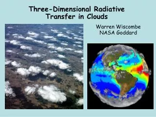
Cloud Groups & Types • Clouds are water droplets suspended in the atmosphere. • Clouds are grouped by their elevation as high, middle, low, and vertical growth. • There are several cloud types in these 4 groups.
Approximate Height of Cloud Bases Above the Surface for Various Latitudes
Cirrus Clouds (Ci) High clouds (above 6000 m in middle latitudes) that are thin and wispy and comprised mostly of ice crystals.
Cirrocumulus Clouds (Cc) High clouds that are rounded puffs, possibly in rows, are less common than cirrus.
Cirrostratus Clouds (Cs) • High clouds that thinly cover the entire sky with ice crystals. • Light passing through these crystals may form a halo.
Altocumulus Clouds (Ac) • Middle clouds (between 2000 and 7000m in middle latitudes) that are puffy masses of white with gray edges. • With your hand overhead, they are about the size of your fingernail.
Altostratus Clouds (As) Middle clouds that cover the entire sky and may create a dimly visible or watery sun and diminish formation of shadows.
Nimbostratus Cloud (Ns) • Low clouds (below 2000m) with precipitation that reaches the ground. • Shredded parts of these clouds are called stratus fractus or scud.
Stratocumulus Clouds (Sc) • Low clouds with rounded patches that range in color from light to dark gray. • With your hand extended overhead, they are about the size of your palm.
Stratus Clouds (St) Low clouds that resemble fog, but do not reach the ground, and can generate a light mist or drizzle.
Cumulus Humilis Clouds (Cu) • Clouds with vertical development that take a variety of shapes, separated by sinking air and blue sky. • Shredded sections are called cumulus fractus. • Known as fair weather cumulus.
Cumulus Congestus Clouds Clouds with vertical development that become higher in height, with tops taking a ragged shape similar to a cauliflower head.
Cumulonimbus Cloud (Cb) Clouds with vertical development that have grown into a towering thunderstorm cloud with a variety of key features, including the anvil top.
Lenticular Clouds An unusual cloud that has a lens shape and forms in the crest of a wave.
Banner Cloud A lenticular cloud that forms downwind of a mountain peak and is regularly replenished by condensing water vapor.
Pileus Cloud An unusual cloud that forms above a building cumulus by deflected moist winds.
Mammatus Clouds An unusual cloud that hangs like sacks which is formed by sinking air of high water content.
Jet Contrails Jet engine exhaust provides vapor and nuclei for condensation trails (contrails), which evaporate quickly in dry air, but linger with higher relative humidity.
Nacreous Clouds Photograph taken by NASA • A cloud resembling a cirrus, showing iridescent coloration when the sun is several degrees below the horizon. • An unusual cloud best viewed at winter in the poles and forms in the stratosphere. (15 -25 km) • Also know as polar stratospheric clouds (PSC)
Noctilucent Clouds Photograph taken by Mika Yrjölä • An unusual wavy cloud that is best viewed near the polar circles and forms in the upper mesosphere. • Most commonly observed in the summer months at latitudes between 50° and 60°. • Located in the upper Mesosphere and lower Thermosphere (75 km – 90 km)
Satellite Observation of Clouds • Geostationary satellites are able to view clouds from above. • As they move in synchronicity with earth's rotation, they can provide continuous coverage for a region and assist in forecasting. • Located ~ 36,000 km (22,369 mi) above the earth’s surface. • GOES = Geostationary Operational Environmental Satellite
Polar Orbiting Satellites • Satellites can detect more than clouds, and polar orbits allow for lower altitudes and more image resolution. • These satellites take multiple passes of the earth before returning to the same location. • The polar orbiting satellites are approximately 850 km above the earth’s surface.
Satellite Imaging Options • Sensors on board the satellite are able to detect visible and other electromagnetic signals, such as infrared, to determine cloud heat and infer its height. • Three major channels: • Visible Light Channel • Infrared Channel • Water Vapor Channel
Cloud thickness and height information can be attained from satellite images. • IR satellite images can tell us the cloud height by how much radiation is the cloud radiating. • Usually, lower the cloud, the warmer its top, hence IR image can distinguish between warm, low clouds (grey) from high, cold clouds (white).
Visible, Infrared, and Enhanced IR Images VIS WV IR • Visible imagery captures all clouds as white, but infrared imagery can distinguish differences. • Infrared imagery can be evaluated and enhanced by a computer program that highlights changes in temperature and cloud types.
False Color Imagery Satellite images can be viewed in false color to more clearly distinguish areas of importance, such as green coolest cirrus clouds and darker gray areas of drier air.