Download
1 / 30
300 likes | 440 Views
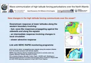
Simulation of Air Traffic Over the North Atlantic Airspace. E. A. Elsayed Rutgers University Presented at TLI Meeting November 15, 2000 Sponsored by FAA 1995-2000. Reykjavik. Gander. Shanwick. New York. Santa Maria. Current Separation Standards. Longitudinal separation 10 min.

E N D
Simulation of Air Traffic Over the North Atlantic Airspace E. A. Elsayed Rutgers University Presented at TLI Meeting November 15, 2000 Sponsored by FAA 1995-2000
Reykjavik Gander Shanwick New York Santa Maria
Current Separation Standards Longitudinal separation 10 min Vertical separation 2000 feet Lateral separation 60 nm
Future Separation Scenarios Vertical Lateral Longitudinal Crossing Baseline RVSM 1 RVSM 2 RVSM 3 RVHSM Free Flight RVSM - Reduced Vertical Separation Minima RVHSM - Reduced Vertical Horizontal Separation Minima
Historical Data • 4th and 15th of each Month in 1996 • All Flights Crossing 20° Longitude in 24 Hour Period • Summer Data from April - October ... 14 Days • Winter Data from November - March ... 10 Days • Military Air Craft Included
Historical Flight Events Format Call Sign AC Type, Mach Fuel Date, US Dollar % Payload Origin - Destination Date, Hour Min Time Track No Restrictions
Classification of Flight Regions Region Description
Flight Regions Region Description
Distribution of Air Craft Types Model 2000 2005 2010
Air Craft Types Model 2000 2005 2010
Verifications: Flight Events • Generation of flight events: NICE groups used the following to generate flight events Traffic growth by region (TFG) Changes in aircraft distributions Speed distributions for aircraft TOW, Directions, Payload Historical data obtained by Iceland Radio for 24 day in 1996
Verifications: Flight Events • Statistically generated flight events: used by NICE-USA • generated flight events were compared with actual flight events of 1996 and future expectations • Incrementally generated flight events: used by NICE-ICE and NICE-UK • add incremental flights to 1996
NICE Models and Verifications AMELIA – Icelandic CAA/University of Icelanl (NICE-ICE) INAATSM – US FAA/Rutgers University (NICE-USA) NATSIM – UK NATS (NICE-UK) LIDO (Flight Planning)
NICE Models • INAATSM – US FAA/Rutgers University (NICE-USA) • Developed an optimization algorithm to obtain optimal flight plans (Minimum Fuel Track) • NICE-USA uses automated conflict detection and reclearance logic, programmed into the fast-time simulation models.
Verifications: Flight Plans • Flight Plans: LIDO vs. NICE-USA Same flight events used by NICE-USA and NICE-ICE and LIDO to determine optimal flight plans. Fuel consumption and origin-destination time are compared.
Typical Flight Plan 1047 11263020840 44.53 57.42 999.00 45.00 48.00 50.00 51.00 51.00 51.00 12.00 35.00 999.00 35.00 37.00 37.00 37.00 39.00 39.00 81092.562500 13121.882812 RN 40.38 73.46 50.02 -8.33 650287.00 159337.062500 24845.792969 KJFK EDDF
SUM -3000 ft -2000 ft -1000 ft 0 1000 ft 2000 ft 3000 ft TOTAL 208 1 35 1 136 0 32 3 % 100% 0% 17% 0% 65% 0% 15% 1% LIDO vs. NICE-USA Flight Plan ComparisonsFlight Levels
SUM - + -4° -3° -2° -1° 0° 1° 2° 3° 4° TOTAL 208 3 5 9 28 51 87 19 10 2 1 % 100% 1% 2% 4% 13% 25% 42% 9% 5% 1% 0% LIDO vs. NICE-USA Flight Plan ComparisonsLateral Deviations