Download
1 / 23
230 likes | 478 Views
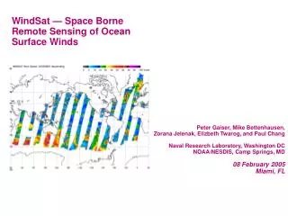
NOAA Ocean Surface Wind Vectors from WindSat Polarimetric Measurements. Zorana Jelenak, Tim Mavor, Laurence Connor, Nai-Yu Wang and Paul S. Chang NOAA/NESDIS/ORA Mike Bettenhausen and Peter Gaiser NRL . WindSat-Mission. Successfully launched on January 6 th 2003 with the objectives to:

E N D
NOAA Ocean Surface Wind Vectors from WindSat Polarimetric Measurements Zorana Jelenak, Tim Mavor, Laurence Connor, Nai-Yu Wang and Paul S. Chang NOAA/NESDIS/ORA Mike Bettenhausen and Peter Gaiser NRL Ocean Wind Vector Workshop, Miami, FL
WindSat-Mission • Successfully launched on January 6th 2003 with the objectives to: • Demonstrate the capability of Polarimetric Microwave Radiometry to measure the Ocean Surface Wind Vector from Space • Show potential to measure other EDR’s: SST, Water Vapor, Cloud liquid water, rain rate, sea ice and snow cover OVW NASA/NOAA Workshop, Miami, FL
Talk Outline • What did we know? • What did we learn? • What is it that we still don’t know? OVW NASA/NOAA Workshop, Miami, FL
Ocean Brightness Temperatures • Tb’s measured by satellite radiometer consists of: • Signal that is emitted from the ocean surface and travels upwards • Upward traveling atmospheric radiation • Downward traveling atmospheric and cold space radiation that is scattered back from the ocean surface OVW NASA/NOAA Workshop, Miami, FL
Theoretical Model OVW NASA/NOAA Workshop, Miami, FL
WindSat Data on PODAAC • SDR’s Ver. 1.6.1 • NOAA EDR’sBased on 1.5.1 SDR’s • NESDIS_0 Algorithm version • NOAA EDR’s Based on 1.6.1 SDR’s • NESDIS_1 Algorithm version • Wind Speed Algorithm • SST Algorithm • QC flag OVW NASA/NOAA Workshop, Miami, FL
CLW Retrievals 18.7,28.8 and 37GHz NOAA WindSat Wind Vector Retrieval Algorithm – Ver 0 Wind Direction Retrievals 10.7, 18.7 and 37GHz 3rd and 4th Stokes WV Retrievals 18.7,23.8 and 37GHz Wind Speed Retrievals 10.7,18.7,23.8 and 37GHz • Ambiguity Removal • 4 possible solution • GDAS initialization • Median filter • 3 passes SST Retrievals 10.7GHz OVW NASA/NOAA Workshop, Miami, FL
CLW Retrievals 18.7,28.8 and 37GHz NOAA WindSat Wind Vector Retrieval Algorithm – Ver 1 Wind Direction Retrievals 10.7, 18.7 and 37GHz 3rd and 4th Stokes WV Retrievals 18.7,23.8 and 37GHz Wind Speed Retrievals 10.7,18.7,23.8 and 37GHz • Ambiguity Removal • 4 possible solution • GDAS initialization • Median filter • 3 passes SST Retrievals 10.7GHz OVW NASA/NOAA Workshop, Miami, FL
WindSat 1.5.1 EDR’s • Data from Sep,2003 to February, 2004 • Retrievals performed over: • Ocean flagged points • Only fore measurements • Retrievals flagged for: • Out of bounds Tb’s • Out of bounds eia • Geographical regions • Rain and ice contamination • High values of wind speed, cloud liquid water and water vapor OVW NASA/NOAA Workshop, Miami, FL
EDR Validation Data Set WS-GDAS-QSCAT-SSMI (Sep, 2003 – Feb, 2004) • Matchup criteria: • 35min between WS-SSMI and • 1h WS-QSCAT • 1h WS-GDAS • 1h QSCAT-GDAS • Validation criteria: • Wspd, based on GDAS wspd • Wind direction based on GDAS wind direction. Two sets of data: • All points that satisfied matchup criteria • Edited set: (WS-GDAS)<90 • WV and CLW bins based on SSMI retrievals • SST bins based on GDAS surface SST OVW NASA/NOAA Workshop, Miami, FL
VER 0 VER 1 OVW NASA/NOAA Workshop, Miami, FL
VER 0 Regression based algorithm -Tbv,h10,Tbv,h18,Tbv23,Tbv37 -tpw dependent -dc dependent VER 1 Regression based algorithm -Tbv10,Tbv,h18,Tbv23,Tbv,h37 -tpw dependent -dc dependent Wind Speed Retrievals OVW NASA/NOAA Workshop, Miami, FL
Wind Speed Algorithm Performances mean OVW NASA/NOAA Workshop, Miami, FL
Wind Direction Validation VER 1 VER 0 OVW NASA/NOAA Workshop, Miami, FL
Algorithm Performance - Wind Direction OVW NASA/NOAA Workshop, Miami, FL
Wind Speed and Directional HistogramsVER 1 OVW NASA/NOAA Workshop, Miami, FL
WindSat QuikScatNovember 5, 2003 (rev 04529) OVW NASA/NOAA Workshop, Miami, FL
WindSat QuikSCAT OVW NASA/NOAA Workshop, Miami, FL
Conclusions • WindSat wind vector retrieval algorithm has been developed and six months of Windsat EDR’s has been released • EDR’s based on 1.6.1 SDR’s will be released in March • A*Tbv-Tbh relationship developed • Almost independent of atmospheric parameters • When used in retrievals instrument skill improves • Initial cal/val done • Initial validation results show that wind speed rms error <2m/s for wind speed between [3-20]m/s • Wind Directional error <25 for wind speeds [5-20]m/s for selected solutions • Large retrieval errors are associated with large values of cloud liquid water and water vapor in the atmosphere OVW NASA/NOAA Workshop, Miami, FL
WindSat Wind Vector Imagery available • http://manati.orbit.nesdis.noaa.gov/windsat • PODAAC WindSat Web page • http://podaac.jpl.nasa.gov/windsat OVW NASA/NOAA Workshop, Miami, FL