Download
1 / 66
660 likes | 833 Views
Building A Weather-Ready Nation. Ken Graham Meteorologist-in-Charge WFO New Orleans/Baton Rouge Kenneth.Graham@noaa.gov 985-649-0429 x4. Our First Building: U.S. Custom’s House on Canal St. November 1871 through March 1915.

E N D
Building A Weather-Ready Nation Ken Graham Meteorologist-in-Charge WFO New Orleans/Baton Rouge Kenneth.Graham@noaa.gov 985-649-0429 x4
Our First Building: U.S. Custom’s House on Canal St.November 1871 through March 1915
Our First Building: U.S. Custom’s House on Canal St.November 1871 through March 1915 Happy 141th Birthday National Weather Service New Orleans
Our Second Building: 600 Camp St. U.S. Post OfficeMarch 1915 through December 1961
National Weather Service Doppler Radar An Eye On The Storms!
Upper Air Observations - Our balloons can reach 100,000 feet!
Tsunami Damage Photo by Ken Graham (National Weather Service)
Hurricane Hurricane Katrina – August 2005
What is a Weather-Ready Nation? A society that is prepared for and can respond to high impact, weather-dependent events
Weather Impacts What You Do! …Incident Support
Why A Weather-Ready Nation? 2010 2009 2008 Tornadoes DWH Ike Wildfires Drought River Flooding River Flooding Wildfires
2011 – Groundhog Day Blizzard • Impacted several central, northern, northeastern states • Brought Chicago to a standstill • $1.8 billion in damages • 36 deaths
2011 – Tornado Outbreaks • 5 outbreaks across central/southern/southeast states • Caused $24 billion in total damage and 545 deaths • Impacted several large, metropolitan areas • EF-5s in MO, MS, AL, and TN
2011 – Drought and Wildfires • Major impacts across TX, OK, NM, AZ, KS, AR, and LA • 2,000 homes and 4,000 other structures lost • Over $9 billion in total losses so far • Losses expected to rise as the event continues
2011 – River Flooding • Record river flooding on the Mississippi River • Additional flooding in the upper midwest • Up to $6 billion in damage • At least 7 deaths
2011 – Hurricane Irene • Landfall over NC and moved northward along the coast • Major flooding in the Northeast due to heavy rains • Over $7 billion in damages • At least 45 deaths
Weather-Ready Nation Vision • Set forward 6 goals seeking to improve services within the various earth and atmospheric sciences • Implement the Weather-Ready Nation Plan by utilizing pilot projects • Build new partnerships and strengthen existing partnerships with the media, private sector weather and climate vendors, researchers and academia, other NOAA agencies, and “decision makers” on the federal, state, and local levels
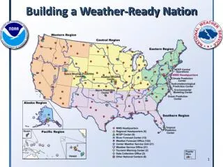
Pilot Projects Boulder, CO Environmental Information Systems and Aviation Research State College, PA WFO/River Forecast Center Enhanced Quantitative Precipitation Forecasts WFO Washington/Baltimore Decision support in an urban region Silver Spring NWS Operations Center Decision support at the national level WFO Charleston, WV Mesoscale Science Monterey, CA Emerging and Collaborative Service Sector: Golden Triangle Expansion Fort Worth, TX Regional Operations Center Decision Support at the regional level WFO New Orleans/Baton Rouge, LA Decision Support in a coastal region WFO Tampa, FL Integrated Environmental Services
We Continue to Focus on the Mission! Mission: To Protect Lives and Property Where Science Impacts Decisions and Decisions Save Lives! Photo by Ken Graham (National Weather Service)
Aviation Weather Briefings Operations were heavily dependent on weather decision support Weather was the GO/NO GO factor on a daily basis beginning at the 0600 briefing
Aviation Decision Support • Low level dispersion flights (100 to 1000 foot winds) • 2nd level spotter flights (500 to 1500 feet) • Mid-level reconnaissance flights (1500 to 5000 feet) • High-level intelligence flights (5000 – 45000 feet/satellite) • Emergency Terminal Forecasts for non-routine locations • NASA Stennis Airport (Staging Area) and Terrebonne-Houma Regional Airport (Incident Command) • Presidential Flight Support
Intelligence Gathering WFO New Orleans prepared a Daily Over-Flight Forecast to aid in satellite imaging data quality and high altitude flights
In-Situ Burns - Fire Weather/Marine Not your typical wildfire or prescribed burn Critical operating levels based on wind direction, wind speed, seas, wave steepness, swells, mixing height, and thunderstorms Main motivation for the hourly spot forecasts
Marine Support Tides Many vessels in tight operations Burns Boom deployment Search and rescue Skimming
Heat Stress • Most event related injuries/illness heat stress related (International Response) • ~ 40% of all reportable injuries. • Critical factor on the beach • 40-20 rule and 20-40 rule • No Tyvek covering • 40 minutes each hour, 20 minutes of supervised rest in a tent. • Full Tyvek protection • 20 minutes work each hour, 40 minutes of supervised rest in a tent.
Tropical Threats Tropical Storm Bonnie • July 23-25, 2010 Tropical Depression Five • August 10-11, 2010 • Direct threats to the area of operations • Prompted 3 day shut-downs • Met 15% criteria
Severe Weather Surveillance 518critical warnings during event • From April 22 – Oct 09 • 22 Tornado Warnings • 112 Severe Thunderstorm Warnings • 358 Special Marine Warnings • 26 Flood/Flash Flood Warnings
“Weather Windows” Clear Weather Forecasting Operational need for calm seas, low winds, and few thunderstorms – Around July 8th, we found a week long window “We think this weather presents a significant opportunity for us to accelerate the process of capping – shutting down the well from the top and increasing the prospects for being able to kill the well from below through the relief wells” – ADM Thad Allen (ret)
Media Interview Coordination Media interviews for oil, hurricanes, and during real time tropical systems We coordinated messages through talking points and huddles through out each day
Simultaneous Incident Responses Mar 30 (pre-spill): Denham Springs Petroleum Warehouse Fire July 30: Mud Lake in Barataria Bay pipeline leak Sep 2: Another Rig explosion south of Cameron, LA Aug 9: New Orleans East train derailment – 19 cars involved Aug 12: Paincourtville, Assumption Parish, LA gas leak (108 spots issued)
WFO New Orleans/Baton Rouge: Decision Support in a Coastal Area • 2,897,606 people living in the forecast area with most people living within 50 miles of the coast and around Lakes Pontchartrain and Maurepas • Select Strategic Assets: LA Offshore Oil Port Stennis-Space Center Federal City Keesler Air Force Base Waterford III Nuclear Plant Northrup-Grumman River Bend Nuclear Plant Mississippi River
WFO New Orleans/Baton Rouge: Decision Support in a Coastal Area Challenges • Over 7,500 miles of coastline subject to an annual threat of land-falling hurricanes • Thousands of miles of navigable waterways subject to both high and low water threats • Severe weather can occur year-round • Early, late, or extreme freezes can adversely affect citrus and berry crops • Above or below normal river flows can significantly impact the seafood industry - especially crawfish and oyster production
WFO New Orleans/Baton Rouge: Decision Support in a Coastal Area A few things we learned during DWH: • Some agencies have not included the NWS in response plans • Routine forecast elements and precision are not always sufficient • Local expertise is invaluable when dealing with a large scale response and an intricate coastline
WFO New Orleans/Baton Rouge: Decision Support in a Coastal Area Goal 1: Ensure WFO LIX is the first call for all weather and water support for all environmental disasters in SE LA and coastal MS • Partner Requirement Services • Understanding Your Thresholds/Trigger Points
WFO New Orleans/Baton Rouge: Decision Support in a Coastal Area Goal 2: 2.5 km Grids Tablets/Smart Phones (Apps.) Decision Maker Tools