Download
1 / 23
250 likes | 393 Views
Learn about contour lines and their importance in representing elevation and land features. Understand different types of contour lines, how to determine elevation, interpret slopes, and identify terrain features using SOSES method.

E N D
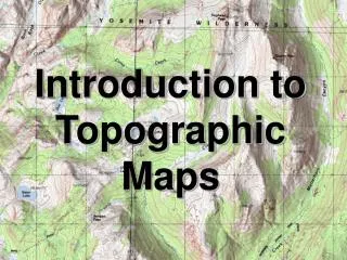
CONTOUR LINES… …lines to show elevation and the shape of the land
Relief • The representation of the shapes of hills, valleys, streams and other features of the earth’s surface • Can be represented by colors for different elevations (called layer tinting), form (dashed) lines to show the basic shape of land, and shading (where the darker the color, the steeper the land) • Most often, relief is shown by CONTOUR LINES
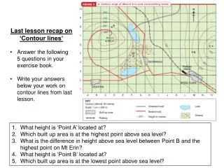
What are contour lines? • Imaginary lines on the ground that represent the same elevation above or below sea level • All points on a contour line are the same elevation
Three types of contour lines • Index lines are the HEAVY or DARK colored contours, generally every fifth contour line; they show an elevation number; often every 100 ft • Four intermediate contour lines fall between the index contours and do NOT show their elevation; often 20 ft • Supplementary contour lines are generally DASHED lines that show one-half the contour interval; often 10 ft
Determining an elevation • Find the contour interval on the marginal map info • Find the nearest INDEX contour and its elevation • Determine if you are going lower or higher to the contour line you are concerned about • Count up or down (generally by 20s) to determine the correct elevation
Benchmarks • Sometimes, you will see a notation such as X BM 214 on a map. That means that map makers have measured that particular spot on the earth’s surface to be exactly 214 feet above sea level
Types of slopes • There are a number of different slopes you can see on a topographic map by noticing the shape of the contour lines: • A uniform gentle slope • A uniform steep slope • A concave slope • A convex slope • The following pictures show you what the slopes look like on the ground and what they look like on a topographic map
Here are some other major terrain features and what they look like on a map and in picture form…
Identify terrain features by SOSES • Shape of the feature at its base • Orientation of the object from your viewpoint • Size of the feature • Elevation of the feature • Slope of the sides of the feature