Download
1 / 11
230 likes | 618 Views
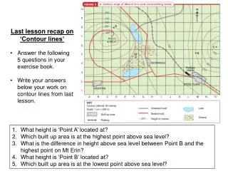
Last lesson recap on ‘Contour lines’ Answer the following 5 questions in your exercise book. Write your answers below your work on contour lines from last lesson. What height is ‘Point A’ located at? Which built up area is at the highest point above sea level?

E N D
Last lesson recap on ‘Contour lines’ • Answer the following 5 questions in your exercise book. • Write your answers below your work on contour lines from last lesson. • What height is ‘Point A’ located at? • Which built up area is at the highest point above sea level? • What is the difference in height above sea level between Point B and the highest point on Mt Erin? • What height is ‘Point B’ located at? • Which built up area is at the lowest point above sea level?
Do you know what the lines on this world map are called? • Do you know what these lines represent?
Latitude and longitude Copy into your exercise book - Lines of latitude and longitude are used to locate places accurately on the Earth's surface. These lines work like a giant grid reference map that covers the entire globe.
Lines of latitude and longitude on a flat map projection of the world
Latitude Copy into your exercise book - Lines of latitude circle the Earth in an east-west direction. They are parallel to each other and are measured in degrees north or south of the equator (0° latitude). The equator also divides the globe into two hemispheres - the northern hemisphere and the southern hemisphere. Draw a simple circle with horizontal, parallel lines in your book to help you remember!
Latitude • Copy into your exercise book – Important lines of latitude include: • The Tropic of Cancer (23.5° north) • The Tropic of Capricorn (23.5° south) • The Arctic circle (66.5° north) • The Antarctic circle (66.5° south) • The North Pole (90° north) • The South Pole (90° south)
Longitude • Copy into your exercise book - Lines of longituderun from the top of the Earth (North Pole) to the bottom (South Pole) in a north-south direction. • They are not parallel as lines of latitude are • They meet at a point at the north and south poles • They are called meridians. • They are measured in degrees. • Important lines of longitude include: • The Prime Meridian (0º longitude) which passes • through Greenwich in London, England. • The International Date Line (180º east/west) Draw a simple circle with vertical lines that meet at the north/south poles in your book to help you remember!
Prime Meridian 0º longitude International Date Line 180º longitude east/west
Latitude and longitude • Task – • Colour the northern hemisphere in with one colour and the southern hemisphere in with another colour. • Draw and label the following latitude and longitude lines on your world map accurately. • The Tropic of Cancer (23.5° north) • The Tropic of Capricorn (23.5° south) • The Arctic circle (66.5° north) • The Antarctic circle (66.5° south) • The North Pole (90° north) • The South Pole (90° south) • Prime Meridian (0º longitude) • The International Date Line (180º east/west) Bonus – If you finish early, you can play the ‘Traveller IQ game. Don’t forget to inform me if you improve on your personal high score!