Download
1 / 19
200 likes | 388 Views
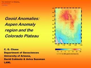
Geoid Anomalies: Aspen Anomaly region and the Colorado Plateau. C. G. Chase Department of Geosciences University of Arizona, David Coblentz & Aviva Sussman LANL. Outline. Geoid anomalies Potential field versus gravity proper Filters and what they tell us (or not) Isostatic compensation

E N D
Geoid Anomalies: Aspen Anomaly region and the Colorado Plateau C. G. Chase Department of Geosciences University of Arizona, David Coblentz & Aviva Sussman LANL
Outline • Geoid anomalies • Potential field versus gravity proper • Filters and what they tell us (or not) • Isostatic compensation • Colorado Plateau • Geoid signal • Elevation • Aspen Anomaly • Yellowstone anomaly much larger in both amplitude and wavelength, could be deep • Aspen anomaly has to be “shallow”
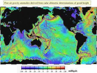
Geoid Anomalies Global geoid anomaly: departure of gravitational equipotential surface (equivalent to sea level) from simple reference figure. Units: m Geoid sees deeper than gravity anomalies (1 / r versus 1 / r 2) That’s good news and bad news Bad - also sensitive to mantle anomalies Good - sensitive to isostatic compensation
GGM02, Nonhydrostatic reference figurel,m (order, degree) <= 360: half-wavelength >= 55 km
Geoid, isostasy, and models Non-uniqueness of potential fields For a specified density distribution, you can only determine a maximum depth Sharp, deep versus broad, shallow One-dimensional geoid models Geoid anomaly mass dipole moment More topography, more anomaly Deeper compensation, more anomaly Full three-dimensional models Models don’t have to be isostatic Spherical harmonics “easy” to work with Need more data and representation geometry
14 For elevation of 2 km 12 10 Airy compensation 8 Geoid/elevation ratio, m/km Pratt compensation 6 4 2 0 0 10 20 30 40 50 60 70 80 90 100 Depth of Moho compensation, km 1-D Geoid to Topography Ratio: Calculated
14 For elevation of 2 km 12 10 Airy compensation 8 Geoid/elevation ratio, m/km Pratt compensation 6 4 2 0 0 10 20 30 40 50 60 70 80 90 100 Depth of Moho compensation, km 1-D Geoid to Topography Ratio: Calculated
Interpretation of 1-D profile Effective compensation depth ~50 km Colorado Plateau now seems to have crustal structure appropriate to elevation Why was Plateau at sea level pre-Tertiary? Possible causes of elevation change: Crustal thickening or removal of dense lithosphere in K
Western US geophysics Topography P-wave tomography
Do the results register? Long-wavelength topography Geoid is north of topography is north of Vp Excess mass on the Colo-Wyo border Depth <= 75 km In their different ways, geoid and topography are quite exact What’s the state of the art for shallow P & S wave tomography? Vp
Conclusions Geoid is useful but requires care in interpreting The right data The right filters The “right” interpretation Compensation under the Colorado Plateau is shallow Definitely upper lithospheric, could be crustal Under the Aspen anomaly, less clear In detail, correlation of geoid with elevation and Vp not exact Lateral density contrasts in both crust and upper mantle implied Halfway to being a Yellowstone anomaly