Download
1 / 34
340 likes | 585 Views
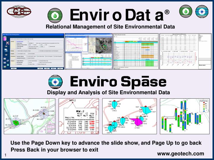
Relational Management of Site Environmental Data. Enviro Title Slide. Display and Analysis of Site Environmental Data. Use the Page Down key to advance the slide show, and Page Up to go back. Press Back in your browser to exit. Introduction.

E N D
Relational Management of Site Environmental Data Enviro Title Slide Display and Analysis of Site Environmental Data Use the Page Down key to advance the slide show, and Page Up to go back Press Back in your browser to exit
Introduction • This slideshow presents the Enviro Data and Enviro Spase programs • These are the leading open-source products for management and mapping of your environmental data • They are widely accepted across the United States and around the world • Both programs have a comprehensive set of useful features, yet are easy to learn and use • And all this comes at a price you can afford
Worldwide Acceptance The Enviro Software is widely accepted across the United States and around the world US Army Corps of Engineers - Widespread project use of software US Dept. of Interior, Bureau of Reclamation - Major river project US Air Force Center for Envir. Excellence - Widespread project use State of California - Software used for emergency response USEPA - Used on hundreds of CERCLA (Superfund) and RCRA projects State of Ohio - Enviro software used on major brownfields projects Oklahoma Water Resource Board - Used on major regional aquifer study ConocoPhillips (Global 500 # 10) - Refinery remediation data BP (Global 500 #4) - Water quality data for natural gas production New York City Dept. of Envir. Protection - Water supply data mgt. and display Newmont Gold - world’s largest gold producer - client for over 15 years 4th largest US environmental company - Enviro users for 10 years, multiple offices International environmental company, client for 9 years, global SW implementation International environmental and construction company - global SW implementation Marathon Oil (Fortune 500 #23) - 20 year client - produced water quality
Founded in 1986, worldwide clientele • Products and services for the earth sciences • Recognized experts in environmental data management (we wrote the book) • Focus on customer satisfaction • Strong industry relationships • Woman-owned small business
You’re drowning in field and laboratory data for your projects Lab deliverables may be incomplete and contain errors Finding data and generating reports and maps is starting to bury you You need to present an accurate picture of the situation at your site Your situation ...
This will let you: • Reduce your expenses • Improve product quality • Gain a competitive advantage • Increase your revenue The solution … Geotech will help you better manage your project data from start to finish with software that is easy to learn and use
Here’s a high level view of the two products Then display your data in GIS Take your samples and enter field data Start by planning your sample events Import the lab, field, and other data Manage data quality as appropriate Select the data for display Then generate your desired output Export data in various formats And improve quality through less data handling Finish your projects in less time
Introduction Have all your data at your fingertips… Graphs Maps Tree Views Reports And much more … all with just a few mouse clicks! www.geotech.com
Now we'll see how Enviro Data makes it easy to: • Plan your sample events • Import data from labs and the field • Perform validation if required • View your data in the database • Generate reports, graphs, and maps • Over 40 standard reports • Customize these reports for project needs • Create your own queries and reports • Provide data to other applications • Export common industry formats • Or connect directly to the data • Save time and money on your projects!
First, create a sampling plan Then create events from that plan Sample Events
Planning the sample event The software generates the samplesand prints the chain of custody www.geotech.com
Enter your data in the field, then import it into the database
Import Wizard “Wizards” make complex tasks easy
Import Wizard Import your data quickly, easily overcoming common problems, while maximizing quality Here the user is finding and fixing inconsistent data
Manage the quality of your data -Including optional CLP-based data validation Validation
Select Data Next, select the data you want to display
Display Options Tell Enviro Data how you want your results formatted -You won’t believe the power and flexibility of this feature!
Reports Then generate your output - Enviro Data has many formats to choose from,or you can create your own for specific project needs
Reports This report shows comparison to four regulatory limits at once
Reports This one shows a simple lithology log There are many more useful output options - all just a few mouse clicks away
eData for the Web You can also display your data on the Web
Supplying data for other applications • You can use Enviro Data as a data source for other software programs • This can be done by exporting data to a file, or by connecting directly to your data • We’ll look at some displays created by other programs using data from Enviro Data
Export Example - Surfer Add some perspective for better insight into spatial relationships This stereo pair was created with Surfer using data from Enviro Data
Export Example - Voxler This 3-D view was created with Voxler using data from Enviro Data
Data Connection Example - ArcGIS Note non-detect exceedence Using ArcGIS to display data from Enviro Data
Enviro Spase • Works with the popular ArcGIS software from ESRI • Easily create sophisticated technical displays of your environmental data • Use data from Enviro Data or other sources • Work directly from the database, or from saved files • Create informative graphics with just a few mouse clicks
Enviro Spase Callouts Crosstab Callouts Stiff Diagrams Stick Logs Graphs Radar Plots
Enviro Spase Post Station Symbols Station Callouts • There are also several utility wizards: • Erase Graphics • Convert Graphics to Layer • Area of Object • Maximize the return on your investment in sampling and analysis
Why improve your data management and display? • The Problem: • Inefficient data management … • Adversely impacts project outcome • Increases costs • Delivers poor quality results • Causes loss of revenue • Reduces competitive advantage • Hard on employee morale • Why it’s important: • Bad data management and display can … • Cause projects to fail • Consultants to lose credibility • Or even lose clients • Inaccurate data or poor presentation can result in negative health impacts • How to solve it: • Enviro Data and Enviro Spase will help you … • Effectively manage and present data • Save time and money • Generate more accurate and understandable results • Be more efficient and increase your revenue through better data management
Benefits of better data management Decrease overhead - One client was able to save $12,000 per year on just one project by moving the data management tasks to a much less expensive clerical person. Lower operating cost - Another client used data management to get their regulator to approve less-frequent sampling intervals for about two of their wells per year, resulting in a savings of $9,000 each year, cumulative from year to year. Increase efficiency – For one client, the time to process an electronic deliverable decreased from an average of 30 minutes to 5 minutes, resulting in an annual savings of $5,000 per year on each project. Increase revenue - A consulting company client was able to use their Enviro Data software and expertise to land a $300,000 data management task from one of their clients.
Geotech - Some of our clients Environmental/Engineering - Weston Solutions, Shaw Environmental, URS, AECOM, ARCADIS, ERM, Stantec, TRC, Delta Environmental, GZA GeoEnvironmental, S&W Redevelopment, Jones Edmunds & Assoc., TestAmerica, Pace Laboratories, ECC, Shield Environmental, Allied Environmental, Hull Environmental Mining/Petroleum - BP Americas, Marathon Oil Co., ConocoPhillips, ExxonMobil, TRONOX Corp., Williams/Transco, Newmont Gold, Eureka Molybdenum Agriculture - Canadian Forest Products, Vineyard Investigations, TerraSpase Government - California Dept. of Health, Ohio EPA, Lake County (FL), Miami Dade County (FL), New York City Dept. of Envir. Prot., Pima County (AZ), U.S. Bureau of Reclamation , Trinity River Authority, Rio Grand Water, Oklahoma Water Resources Board, City of Pomona (CA) Native American - Jicarilla Apache Nation, Pueblo of Laguna, Santa Clara Pueblo, Iowa Nation