Download
1 / 43
430 likes | 638 Views
Tropical cyclone climate projections by a 20-km-mesh high-resolution MRI/JMA global atmospheric model. CWB Seminar 15 Aug 2011 Hiroyuki Murakami (JAMSTEC/MRI). Japan Agency for Marine-Earth Science and Technology (JAMSTEC), and Meteorological Research Institute. Outline.

E N D
Tropical cyclone climate projections by a 20-km-mesh high-resolution MRI/JMA global atmospheric model CWB Seminar 15 Aug 2011 Hiroyuki Murakami (JAMSTEC/MRI) Japan Agency for Marine-Earth Science and Technology (JAMSTEC), and Meteorological Research Institute
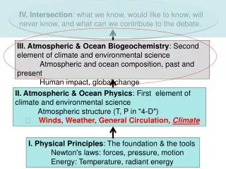
Outline • Review of previous studies on projected future changes in tropical cyclones (TCs) • KAKUSHIN program conducted by MRI • Projected future changes in TC activities in the western North Pacific (WNP) using the 20-km mesh MRI-AGCM. • Up-to-date results. • Summary 20 km-mesh grids
・Global models (CGCMs or AGCMs) Broccoli and Manabe, 1990; Haarsma et al., 1993; Bengtsson et al., 1996; Krishnamurti et al., 1998; Royer et al., 1998; Sugi et al., 2002; Tsutsui, 2002; McDonaldet al., 2005; Chauvin et al., 2006; Oouchi et al., 2006; Yoshimura et al., 2006; Bengtsson et al., 2007; Gualdi et al., 2008; Zhao et al., 2009 ・Regional models Knutson et al., 1998; Knutson and Tuleya, 1999; Nguyen and Walsh, 2001; Knutson and Tuleya, 2004; Walsh et al., 2004; Stowasser et al., 2007; Knutson et al., 2008; Bender et al., 2010 Review on impact of global warming on TC activities etc. 1.Consistent results(consensus) ・A reduced frequency of TCs globally ・A future increase of intense TCs 2. Inconsistent results(uncertainty) ・Difference in projected future changes in TC frequency in a specific ocean basin Among 14 previous numerical studies, 5 indicated an increase in the NA, while 9 reported a decreasing frequency (Murakami and Wang, 2010) 3. Not investigated(unknown) ・Effect of global warming on TC activities in a specific ocean basin
Why do we need a high resolution model? Projections by previous climate models are not reliable because the models are too coarse to resolve TC structures. Only models finer than 60 km-mesh show future increase in intense TCs(Murakami and Sugi, 2010). 20km 60km 180km 270km Observations (1979-2003 ) High resolution model yields realistic TC structure. Present 25year (1979-2003 ) Future 25year (2075-2099 ) ●:significant increase at 95%level ●:significant decrease at 95% level
KAKUSHIN Program (2007 – 2012) conducted by MRI CMIP3 AOGCMs 20km AGCM Regional Climate Model 5km NHM 2km, 1km NHM A A SST Nested in the 20kmAGCM Nested in the 5km NHM Lower B.C. Projected SST O Future Near Term SST Present Observed SST (AMIP-type) Obs + Projected SST change Year 2075 ~ 2099 2015 ~ 2039 1979 ~ 2003
KAKUSHIN Program (2007 – 2012) conducted by MRI Detailed Projection around Japan Study of Future Change in Extreme Events • Tropical Cyclones (e.g.Murakami et al. 2011)less number, more intense • East Asia Monsoon (e.g.Kusunoki et al.2011)seasonal migration delayed • Extreme Rainfall (e.g.Kamiguchi et al. 2006)more frequent • Blockings(e.g.Matsueda et al. 2009)less frequent • Extratropical Cyclones • Regional Climate Change • Outputs provided to researchers of each region(Korea, China, Taiwan, Philippines, Thailand, Indonesia, Viet Nam, Bangladesh, India, Israel, Saudi Arabia, Senegal, Spain, Netherland, UK, Ireland, Denmark, Switzerland, Germany, USA, Mexico, Columbia, Barbados, Belize, Bolivia, Peru, Ecuador, Brazil, Argentina, Australia, Papua New Guinea ) Impact Assessments • Disasters • Agriculture • Water Resources
MRI-AGCM Previous version (contributed to IPCC AR4) New version (for IPCC AR5)
Mizuta et.al (2008) How to prescribe SST CMIP3 ensemble mean SST under the A1B Scenario Experiment Present SST Observed SST 1979~2003 ΔSST AR4_20thCentury Exp. SST-2001 • 2003 2075 2099 25 years 25 years Future SST also applies for 2015-2039 CMIP3 SST change CMIP3 SST Trend 2075-2099 Inter-annual variability of Observed SST 1979-2003 + = + ΔSST Mean SST(2075-2099) – Mean SST(1979-2003)
Spatial pattern of prescribed future changes in SST 21st (2075-2099) – Present (1979-2003) ・Relatively larger increase in SST in the Northern Hemisphere than in the Southern Hemisphere. ・The SST increase is the largest in the tropical Central Pacific.
Future change of western North Pacific typhoons: Projections by a 20-km-mesh global atmospheric model Reference: Murakami, H, B. Wang, and A. Kitoh, 2011:Future change of Western North Pacific typhoons: Projections by a 20-km-mesh Global atmospheric model., J. Climate, 24,1154-1169.
TC detection criteria Simulated TCs are detected using 6-hourly data by following 6 criteria. • Sea level pressure = 2.0 hPa lower than the surroundings area. • 850 hPa Relative volticity = 3.0 ×10⁵ /s • 850 hPa Maximum wind speed = 10.0 m/s • Warm Core: 1.0 K • Duration =36 hours • Maximum wind speed at 850 hPa should be greater than the 300 hPa (to exclude extra-tropical cyclones). Based on Oouchi et al. (2006)
Simulated TC trakcs Observations (1979-2003) PD (1979-2003) TC tracks are well simulated by the PD experiment.
Projected future changes in the TC tracks eastward shift eastward northward eastward westward decreasing GW (2075-2099) TC number reduced by 16% (23%) globally (in the western North Pacific). Projected Future Changes in the TC Frequency (GW-PD)
Future change in “Landing” tropical cyclones (a) July-October mean of TC frequency near coasts increase decrease decrease decrease increase (b) Mean maximum wind velocity of TCs near coasts The frequency of tropical cyclones approaching Japan and Korea may decrease in the future. However, once a TC approaches the coast lines, mean of maximum wind velocity is larger than the present climate, leading to a catastrophic damage in the future. increase
What causes TC track changes? Steering flow (850-300hPa) changes Steering flow changes (westerly flow anomaly) partly explain TC track changes by inhibiting westward TC motion. TC genesis frequency changes TC genesis location changes (eastward shift) mainly explain TC track changes.
Genesis Potential Index (GPI) To determine the factors behind such genesis changes, we used a Genesis Potential Index (GPI) by Emanuel and Nolan (2004) with some modifications. Absolute Vorticity at 850hPa Relative Humidity at 700hPa Maximum Potential Intensity Vertical Wind Shear (850- 200hPa) Vertical Wind Velocity at 500hPa Future changes in TC genesis frequency GPI changes Spatial correlation coefficient is 0.55. GPI performs reasonably well in reflecting the changes in TC genesis frequency.
Each term contribution to the changes in GPI • Thermodynamic changes • has less influence. • =>Relative humidity and • Potential intensity tend to • cancel each other. 2. Dynamical changes have great influences. =>Vorticity and vertical wind shear contribute to the increase in GPI in the eastern WNP. =>Vorticity and vertical wind velocity contribute to the decreasein GPI in the western WNP. Relative humidity Potential Intensity Vertical Wind Shear Vertical Wind Velocity Vorticity
Mechanisms of future changes in TC genesis Rossby wave response: Positive vorticity => Increase in TC genesis in the eastern WNP L Weakening of the Walker circulation: Decrease in upward motion => Decrease in TC genesis in the western WNP Future changes in vertical wind velocity at 500 hPa Downward anomaly Upward anomaly
Why is upward motion changes in the tropical central Pacific? Future changes in vertical motions (top) appear to be strongly related to the prescribed SST anomaly (bottom), indicating that spatial distribution of tropical SST may be a key factor for TC activities.
Conclusion(I) The projected TC activity change during the peak typhoon season (JASO) indicates: Positions of the prevailing northward recurvingTC tracks will shift eastward over the open ocean of the WNP; (b) TC track changes are partially due to changes of the large scale steering flows, but primarily owning to the changes in TC-genesis locations: TC formation will be less to the west of 140E, whereas more in eastern WNP (017N, 140180E) (c) The decrease in the TC genesis frequency in the western WNP are mainly due to in situreduction of the large scale ascent, which is caused by the enhanced descending branch of the zonal circulation (i.e., weakening of the Walker circulation). (d) The enhanced TC genesis in the eastern WNP is due to the increased in situ low-level cyclonic vorticity, reduced vertical wind shear, caused by Rossby wave response induced by enhanced diabatic heating in the central tropical Pacific.
Preliminary results with the new 20-km mesh model Murakami et al. (J. Climate, submitted)
MRI-AGCM Previous version (contributed to IPCC AR4) New version (for IPCC AR5)
Arakawa- Schubert Tiedtke Only a single convective updraft but represented as a more derailed entraining and detraining plume Multiple convective updrafts with different heights depending on entrainment rates explicitly calculated New scheme (Yoshimura Scheme) Two Tiedtke-type updrafts are calculated Updrafts between min. and max. rates are assumed to be continuously present. Temperature, water vapor mixing ratio, entrainment rate etc. are obtained by linear interpolation between the two. Multiple updrafts with different heights are represented.
Previous model New model Improved Improved Problems with the previous 20-km mesh MRI-AGCM The number for each basin show the annual mean number of TCs. Predicted TC number in the WNP is underestimated. TC intensity is weak compared with observations Murakami et al. (2011, submitted)
Comparison of projected future changes between models Frequency of TC occurrence Previous model New model Both models show significant decrease in TC frequency over the South Pacific and western portion of WNP. Both models show significant increase in TC frequency over the central Pacific. Inconsistent in the eastern quadrant of WNP
Weakening of Walker Circulation Previous model (dω500) Tropical total upward (downward) mass flux: -6.3% (-6.4 %) New model (dω500) □:zonal ●:asymetric 赤:New model 青: Previous model Vecchi and Soden (2007, J.Climate) Tropical total upward (downward) mass flux: -5.1% (-5.1 %) Projected Walker circulation is weakened in both models
Present 25year (1979-2003 ) Future 25year (2075-2099 ) ●:significant increase at 95%level ●:significant decrease at 95% level Comparison of projected future changes between models TC intensity Previous model New model Both models show significant decrease in the frequency of weak TCs. New model projects a more subtle increase in the frequency of intense TCs.
Category 5 TC frequency of occurrence Unit: number per 25 years The frequency of C5 TCs appears to increase in the northern portion of the WNP basin. Note that the tracks of C5 TCs in the present-day simulation show a northward shift relative to observations.
Conclusion (II) We developed a new high-resolution AGCM for more reliable climate projections especially in extreme events such as TCs. Projected results are characterized as: A significant increase in the frequency of intense TCs with global warming occurs in both models. However, the increase is smaller in the new model than the previous model. (b) The projected future changes in the TC frequency of occurrence show large spatial variations: significant decrease in the western quadrant of WNP and SPO, and significant increase in the Central Pacific. (c) The new model suggests that the frequency of Category 5 TCs increases in the northern portion of the WNP, indicating that TC-related socioeconomic damage may become more severe under global warming.
Preliminary results of multi-model and multi-SST experiments using the new 60-km mesh model Murakami et al. (In preparation)
Multi-model & Multi-SST Ensemble Projections using 60-km-mesh model
Multi-model & Multi-SST Ensemble Projections using 60-km-mesh model
Future changes in TC number [%] Y: Yoshimura, K:Kain-Fritsch, A: Arakawa Shubert 0: CMIP3 SST, 1:Cluster 1, 2:Cluster 2, 3: Cluster 3, G: Global uniform
Future changes in TC frequency and genesis frequency Cross mark indicates that the difference is statistically significant at the 90 % confidence level or above and more than 10 experiments show the same sign of the mean change.
Conclusion (III) In order to evaluate uncertainties, we conducted multi-SST and multi-model ensemble projections. Every ensemble simulation commonly shows decrease in global and hemispheric TC genesis numbers by about 535% under the global warming environment regardless of the difference in model cumulus convection schemes and prescribed SSTs. All experiments tend to project future decreases in the number of TCs in the western North Pacific (WNP), South Indian Ocean (SIO), and South Pacific Ocean (SPO), whereas they commonly project increase in the central Pacific. The projected changes in the North Atlantic, North Indian (NIO), and eastern North Pacific (ENP) are inconsistent among the experiments and even the sign of future changes is inconsistent.
Reference Murakami, H. and M. Sugi, 2010: Effect of model resolution on tropical cyclone climate projections. SOLA, 6, 73–76. Murakami, H., and B. Wang, 2010: Future change of North Atlantic tropical cyclone tracks: Projection by a 20-km-mesh global atmospheric model. J. Climate, 23, 2699–2721. Murakami, H., B. Wang, and A. Kitoh, 2011: Future change of western North Pacific typhoons: Projections by a 20-km-mesh global atmospheric model. J. Climate, 24, 1154–1169. Murakami, H., and co-authors, 2011: Future changes in tropical cyclone activity projected by the new high-resolution MRI-AGCM. J. Climate submitted. Murakami, H., R. Mizuta, and E. Shindo, 2011: Future changes in tropical cyclone activity projected by multi-model and multi-SST ensemble experiments using 60-km mesh MRI-AGCM. in preparation.
MPI (Maximum Potential Index) where Ck is the exchange coefficient for enthalpy, CD is the drag coefficient, Ts is the SST (K), and T0 is the mean outflow temperature (K). The quantity CAPE* is the value of convective available potential energy (CAPE) of air lifted from saturation at sea level, with reference to the environmental sounding, and CAPEb is that of the boundary layer air. Both quantities are evaluated near the radius of maximum wind which is theoretically determined.
In recent years, TCs become more active. Hurricane activity in the North Atlantic (NA) showed an increase over the past 30 years. Hurricane Katrina (2005) : the most damaging storm in USA Hurricane Rita (2005) : the most intense (895 hPa) TC observed in the Gulf of Mexico Hurricane Wilma (2005) : the most intense (882 hPa) TC in NA Review on impact of global warming on TC activities (Part. I) In recent years, TCs become more active. Hurricane activity in the North Atlantic (NA) showed an increase over the past 30 years. Hurricane Katrina (2005) : the most damaging storm in USA Hurricane Rita (2005) : the most intense (895 hPa) TC observed in the Gulf of Mexico Hurricane Wilma (2005) : the most intense (882 hPa) TC in NA Abnormal TC number in the western North Pacific in 2004. Typhoon Morakot in 2009 caused catastrophic damage in Kaohsiung in Taiwan.
Previous studies have proposed that these recent changes are due to global warming. Emanuel, 2005; Anthes et al., 2006; Hoyos et al., 2006; Mann and Emanuel,2006; Trenberth and Shea, 2006; Holland and Webster, 2007; Mann et al., 2007a; Mann et al., 2007b Review on impact of global warming on TC activities (Part. II) However, this view has been challenged by the following points: a) The observation before satellite era (before 1979) is not reliable. Landsea et al., 2006; Landsea, 2007 b) Recent increases in the frequency of NA TCs are within the range of multi-decadal variability. Pielke et al., 2006;Bell and Chelliah, 2006 c) Projectons by climate models are not reliable because the models are too coarse to resolve TC structures. Goldenberg et al. 2001. TC scale is 100-1000 km, while typical horizontal resolution of climate models is100-300 km mesh.
Global Precipitation (JJA) OBS(CMAP) diff from OBS New Model20km25years Prev Model20km25years
Asian summer monsoon (JJA mean) Colors: Precipitation Arrows: 850hPawind Contours: Thickness(200-500hPa) OBS(JRA+CMAP) diff from OBS New Model20km25years Prev Model20km25years
Skill score of 25-year climatology Skill Score by Taylor (2001) σ: standard deviation (model/obs), R: correlation coefficient ■Better at New Model ■Better at Prev Model Jan Jul Global Asia