Download
1 / 16
160 likes | 330 Views
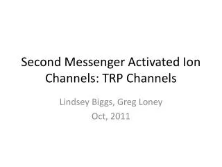
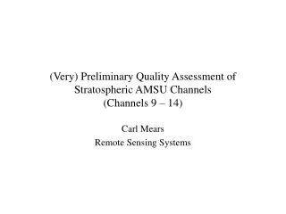
(Very) Preliminary Quality Assessment of Stratospheric AMSU Channels (Channels 9 – 14). Carl Mears Remote Sensing Systems. AMSU and SSU Weighting Functions. SSU 27. SSU 26. AMSU 13. SSU 25. AMSU 12. AMSU 11. SSU 15x. AMSU 10. AMSU 9.

E N D
(Very) Preliminary Quality Assessment of Stratospheric AMSU Channels(Channels 9 – 14) Carl Mears Remote Sensing Systems
AMSU and SSU Weighting Functions SSU 27 SSU 26 AMSU 13 SSU 25 AMSU 12 AMSU 11 SSU 15x AMSU 10 AMSU 9
Problems with AMSUMid-Troposphere Funny behavior for near-limb views
Problems with AMSU(Near Tropopause) Other channels at least as bad! Some indication that target factor could be FOV dependent!
Problems with AMSU • How do we figure out which AMSU instrument is bad (or at least, less bad) • Radiosondes probably not accurate enough • Time period too short for water vapor to help • NOAA-16 farther way from NOAA-14 MSU (but this is an old instrument) • Solution: Figure out which AMSU has a more consistent dataset by looking at all channels (and nadir vs limb views)
Probable vertical structure of trends Tropopause Height Trend
Trends – NOAA-15 and NOAA-16Tropical Oceans, 30S to 30N NOAA-15: Fairly consistent except for Channel 6. NOAA-16: All channels inconsistent except for (maybe) channel 4.
Trends – NOAA-15 and NOAA-16 Tropical Oceans, 30S to 30N, 2002-2006 NOAA-15: Fairly consistent except for Channel 6. NOAA-16: All channels inconsistent except for (maybe) channel 4. Conclusion: NOAA-16 more likely to be the problem – NOAA-16 is removed.
Now, the Stratosphere • Basis strategy – apply the same analysis to the stratospheric channels to see if NOAA-16 has problems for these channels too. • Very preliminary, since we have not performed any diurnal adjustment. • Difficult to evaluate channels 11 and 14 due to short (or zero) overlap
Trends, 2002-2006, K/decade60S to 60N • Trends broadly consistent for all stratospheric channels • Nadir-limb difference seems too large • related to diurnal drift?
Channel 10 Time Series For Channel 10, everything is fairly well behaved. Temperature Temperature Anomaly NOAA-16 – NOAA 15
Channel 12 Time Series For Channel 12, descending node shows significant drift. Temperature Temperature Anomaly NOAA-16 – NOAA 15
Adjusting for drifts in measurement time NOAA-15 NOAA satellites drift in local measurement time NOAA-16 If uncorrected, these would lead to spurious long-term signals in the dataset.
NOAA-16 minus NOAA-15 differencesby field of view. Drift in descending node strongly dependent on field of view. At least part of this is due to drift in measurement time.
Conclusions • Where we can evaluate them, the stratospheric channels on AMSU appear to be in better shape than the tropospheric channels. • Need to come up with a reasonable diurnal adjustment • 4 AMSUs with different measurement times • Stratospheric model data with output every 3 hours • Microwave Limb Sounder probably not useful.