Download
1 / 29
290 likes | 418 Views
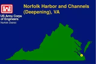
Norfolk Harbor and Channels (Deepening), VA. Navigation on the Elizabeth River. Navigation on the Elizabeth River falls under the Norfolk Harbor and Channels Project. Norfolk Harbor and Channels. A system of channels and anchorages serving the Port of Hampton Roads

E N D
Norfolk Harbor and Channels (Deepening), VA
Navigation on the Elizabeth River falls under the Norfolk Harbor and Channels Project
Norfolk Harbor and Channels • A system of channels and anchorages serving the Port of Hampton Roads • Project constructed in useable elements based on the needs and financial capability of the Commonwealth of Virginia
Authority Water Resources Development Act of 1986 (Public Law 99-662)
Local Cost-Sharing Sponsor Commonwealth of Virginia acting through its agent, the Virginia Port Authority
N Craney Island
Project Elements • 55-Foot Element • 55-Foot Outbound & 55-Foot Inbound • 50-Foot Element • 50-Foot Outbound & 50-Foot Inbound • 50-Foot Anchorage
Project Elements(Cont’d) • Elizabeth River Elements • 40-Foot Channel & 45-Foot Channel • Navigation Management Plan • Dredged Material Management
Completed Elements • 50-Ft Outbound Channel 1989 • 50-Ft Anchorage 1999 • Navigation Mgnt. Plan 2000
Element Near Completion 50-Ft Inbound Channel • Thimble Shoal Channel 2004 • Norfolk Harbor Channel 2005 • Atlantic Ocean Channel 2006
45-Ft Authorized ProjectElizabeth River • From Lamberts Point to junction of Eastern and Southern Branches • 3 miles long • Currently maintained to 40 feet
45-Ft Authorized ProjectSouthern Branch • From the junction of Eastern and Southern Branches to the Norfolk and Southern Railroad Bridge • 3 miles long • Currently maintained to 40 feet
40-Ft Authorized ProjectElizabeth River • From Norfolk and Southern Railroad Bridge to the Gilmerton Bridge • 2.4 miles long • Currently maintained to 35 feet
40-Ft Authorized ProjectElizabeth River (Cont’d) • Had started detailed design on this project in the mid-1990’s. • Design was put on hold pending navigation need and local sponsor support.
Process to Construction • Obtain Federal and Non-Federal funding needed start Detailed Design Phase • Conduct Detailed Design Investigations • Advertise and award construction contract • Construct and manage the project.
Process to ConstructionFunding Hope to obtain Federal and Non-Federal funds in FY 2007 or 2008
Process to ConstructionDetailed Design Investigations Should take proximately two years to complete.
Process to ConstructionConstruction Each Elizabeth River project could be completed in approximately one year
Process to ConstructionProject Approval and Construction Funding Should take proximately one year
Tentative Implementation Schedule • Funding FY 08 • Detailed Design FY08—FY09 • Project Approval and Construction Funding FY09 • Construction FY10
Norfolk Harbor and Channels (Deepening), VA