Download
1 / 5
50 likes | 196 Views
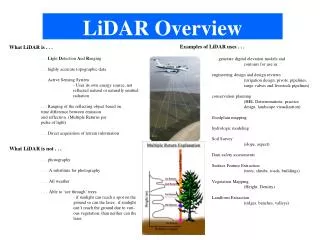
BSHC LIDAR S eminar SMA e xperiences from and future plans of LIDAR surveys. SMA LIDAR surveys 1996-2002. System: HawkEye I Carrier: Helicopter Positioning : DGPS. Depth range : ~1-20 m Sounding density : ~5 per 5x5 m. LIDAR surveys along the coast of Skåne and Öland.

E N D
BSHC LIDAR Seminar SMA experiencesfrom and futureplans of LIDAR surveys
SMA LIDAR surveys 1996-2002 System: HawkEye I Carrier: Helicopter Positioning: DGPS Depthrange: ~1-20 m Soundingdensity: ~5 per 5x5 m LIDAR surveysalong the coastof Skåne and Öland LIDAR and multibeam surveys in the Stockholm archipelago, partly for the Navy ~6,6 km ~5 km • Common problems: • Any existing depths/contours shallowerthan the LIDAR-resultwerekept in the chart • HowtohandlesingleLIDAR soundingindicatingshallow spot
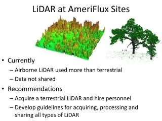
Recent LIDAR experiencesfrom the research program EMMA (EnvironmentalMapping and MonitoringwithAirborne laser and digital images on land and at sea) Leftpicture: Multibeam Reson 7125 (2013), 1x1 m bin size. An enormousnumberof rocks/boulders. Comparativesurfaces, ~1000x750 m, depthrange 2,5-11 m Right picture: HawkeyeII (2010), 5x5 m bin size. In general, similarpictureof the seafloor as for the multibeam, except the total absenceof features/rocks. Gaps in data - no bottomreflect signal. Lowsoundingdensity -> low DTM resolution
EMMA results: Feature detection – LIDAR versus multibeam Multibeam: Averagedepth: ~6 m Shallowestsounding: 2,75 m Boulder: 5x5 m och 3 m high Boulder: 3x3 m och 2,2 m high Hawkeye II: Shallowestsounding at boulder position: ~5 m, no signsofbottomreflection on the boulders, processed XYZ-data (no raw data toanalyze) Purple points from multibeam White points från Hawkeye II
Future LIDAR plans… • Project Surveyingshallowwaters 2104-2015 • By directionof MSB – Swedish Civil ContingenciesAgency • Project leader SMA Hans Öiås • To study: • Costeffective systems tomapshallowwaters < 10 m (coastal, lakes, rivers) towards the coastline • Analyze different acquisition techniques(LIDAR, echo-sounders) • Pros and cons: quality, costs, time, information • Survey plan on what system tousewhere • Practical fieldtrials