LIDAR
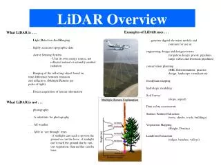
LIDAR. David Webb- VWCC. LIDAR. LIDAR , LiDAR , LIDaR, lidar and LADAR(laser altimetry). Light detection and ranging Laser Imaging, Detection and Ranging Combining the words light and radar. My most common thought about the subject…. LIDAR Types. Airborne Topographic Bathymeric


LIDAR
E N D
Presentation Transcript
LIDAR David Webb- VWCC
LIDAR LIDAR, LiDAR, LIDaR, lidar and LADAR(laser altimetry). Light detection and ranging Laser Imaging, Detection and Ranging Combining the words light and radar My most common thought about the subject….
LIDAR Types • Airborne • Topographic • Bathymeric • Terrestrial • Mobile • Stationary
Stationary Easter Island Moai http://trl.trimble.com/docushare/dsweb/Get/Document-421274/
LIDAR – Airborne Topographic • Active Remote Sensing method. • Laser pulses are reflected from objects on or near the ground. • XYZ data collected. • High density of data points collected. http://www.fs.fed.us/pnw/pubs/pnw_gtr768.pdf
LIDAR Returns • Multiple returns. • First is the highest object. • Up to five (5) returns per pulse. • Last is not always the ground. http://resources.arcgis.com/en/help/main/10.1/index.html#//015w00000041000000
File Types • LAS – specification for a point cloud file format with x,y,z and other attributes. • ASCII – original format for LIDAR data. • LAZ – lossless LIDAR Compression. http://www.laszip.org/ • Data we will use compressed from 164 mb to 29 mb. • LAS Dataset –LAS storage for use in ArcGIS. • Convert into TIN, DEM, contours and others.
Uses of LIDAR • Flooding • Coastline erosion- changes • Vegetation • Forestry • Improving accuracy and resolution of basemaps. • Planning • Urban Growth
Find Data • Virginia- William and Mary hosts state LIDAR http://www.wm.edu/as/cga/VALIDAR/index.php • USGS CLICK: Center for LIDAR Information Coordination and Knowledge (not compressed!) http://lidar.cr.usgs.gov/ • LIDAR LINKS for mappers http://www.lidarbasemaps.org/
Why LIDAR? • Jamestown • Civil War Redoubts • Coastal LIDAR http://www.davidrumsey.com/luna/servlet/detail/RUMSEY~8~1~26954~1100253:Battery-Sawyer,-Va---Battery-Pruyn,
Colonial Parkway • Three Civil War era forts. • Document condition. • Student service learning and fieldwork.