Download
1 / 28
280 likes | 297 Views
Explore the background, policies, and initiatives of the Landsat program, including key legislation, roles of agencies, and future directions for land imaging and remote sensing. Learn how Landsat data is utilized for environmental monitoring and disaster response.

E N D
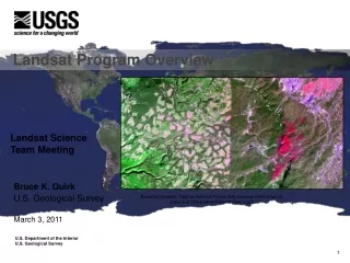
Landsat Program Overview Landsat Science Team Meeting Bruce K. Quirk U.S. Geological Survey March 3, 2011 Boundary between Targhee National Forest (left) showing forest clear cut areas and Yellowstone National Park (right) U.S. Department of the Interior U.S. Geological Survey
Discussion Topics • National Space Policy • Collection and Analysis of Land Imaging Requirements • Future Landsat Missions
Landsat Policy Land Remote Sensing The Secretary of the Interior, through the Director of the United States Geological Survey (USGS), shall: • Conduct research on natural and human-induced changes to Earth’s land, land cover, and inland surface waters, and manage a global land surface data national archive and its distribution; • Determine the operational requirements for collection, processing, archiving, and distribution of land surface data to the United States Government and other users; and • Be responsible, in coordination with the Secretary of Defense, the Secretary of Homeland Security, and the Director of National Intelligence, for providing remote sensing information related to the environment and disasters that is acquired from national security space systems to other civil government agencies. In support of these critical needs, the Secretary of the Interior, through the Director of the USGS, and the NASA Administrator shall work together in maintaining a program for operational land remote sensing observations. June 28, 2010
Landsat Policy, cont. Land Remote Sensing The NASA and NOAA Administrators and the Director of the USGS shall: • Ensure that civil space acquisition processes and capabilities are not unnecessarily duplicated; and • Continue to develop civil applications and information tools based on data collected by Earth observation satellites. These civil capabilities will be developed, to the greatest extent possible, using known standards and open protocols, and the applications will be made available to the public. The Secretary of Commerce, through the Administrator of NOAA, shall provide for the regulation and licensing of the operation of commercial sector remote sensing systems.
Land Imaging Legislation and Policy • National Space Policy Directive 5 (NSPD-5), “Landsat Remote Sensing Strategy” Signed by President George H.W. Bush February 13, 1992. Reiterates the importance of Landsat data. • Public Law 102-555, “Land Remote Sensing Policy Act of 1992” (US Code Title 15, Chapter 82) Passed by Congress and signed by President George H.W. Bush October 28, 1992. • Presidential Decision Directive NSTC-3, “Landsat Remote Sensing Strategy” • Signed by President William Clinton May 5, 1994. Supersedes NSPD-5 but carries forward key aspects of it and Public Law 102-555 • Amended and signed by President William Clinton October 16, 2000. Directs DOI to manage and operate Landsat 7 ground and flight systems • U.S. National Space Policy, Signed by President George W. Bush August 31, 2006. Delegates wide-ranging responsibilities to civil, defense, and intelligence agencies and provides guidelines for civil space agencies to increase the benefits of operational environmental monitoring activities. • “A Plan for a U.S. National Land Imaging Program” Issued by the White House Office of Science and Technology Policy August 7, 2007. Recognizes the failure of commercialization of moderate-resolution (Landsat-like) systems • “Earth Science and Applications from Space: National Imperatives for the Next Decade and Beyond” A report published in 2007 by the Space Studies Board of the National Research Council of the National Academies • National Space Policy: Revision released June 28, 2010. Directs DOI, through the USGS, to “… determine the operational requirements for collection, processing, archiving, and distribution of land surface data to the United States Government and other users;” and to work with NASA “…in maintaining a program for operational land remote sensing observations.”
Future of Land Imaging Report • Under the National Science and Technology Council (NSTC), nine Federal agencies studied the Landsat Program throughout 2006, then NSTC made three recommendations in 2007: • The U.S. must commit to continue the collection of moderate-resolution imagery • The U.S. should establish and maintain a core OPERATIONAL capability to collect moderate-resolution land imagery through U.S.- owned satellites • The U.S. should establish the National Land Imaging Program, hosted and managed by the Department of the Interior
NASA and DOI/USGS Evolving Landsat Roles Landsat responsibility shifts from NASA to DOI/USGS
Questions? New LDCM browse product
Landsat Policy Land Remote Sensing The Secretary of the Interior, through the Director of the United States Geological Survey (USGS), shall: • Conduct research on natural and human-induced changes to Earth’s land, land cover, and inland surface waters, and manage a global land surface data national archive and its distribution; • Determine the operational requirements for collection, processing, archiving, and distribution of land surface data to the United States Government and other users; and • Be responsible, in coordination with the Secretary of Defense, the Secretary of Homeland Security, and the Director of National Intelligence, for providing remote sensing information related to the environment and disasters that is acquired from national security space systems to other civil government agencies. In support of these critical needs, the Secretary of the Interior, through the Director of the USGS, and the NASA Administrator shall work together in maintaining a program for operational land remote sensing observations. June 28, 2010
USGS FY 2012 President’s Budget National Land Imaging +$48.0 million A new account is proposed for Landsat missions. Landsat furthers the Department of the Interior’s important role in land and remote sensing under the President’s National Space Policy and provides invaluable data for land use and climate change research. The new account will include funding for current satellites (Landsats 5 and 7); the Landsat Data Continuity Mission (Landsat 8), which is scheduled to launch in December 2012; and the development of Landsats 9 and 10, through a continuous Landsat program that will ensure data continuity in the future. “There is no commercial replacement for the breadth and depth of data collected by Landsat satellites, which are then used in a multitude of ways by the agricultural, water management, disaster response, and scientific communities,” said Director McNutt. “Because Landsat enables us to see Earth’s surface so clearly, so broadly, so objectively, we gain invaluable insights about the complexity of Earth systems and the condition of our natural resources.”
USGS FY 2012 President’s Budget National Land Imaging – The 2012 budget provides a total of $99.8 million in a new account for the National Land Imaging Program, an increase of $59.6 million from Landsat funding at the 2010 Enacted/2011 CR level. This new account is established to carry out the Department of the Interior’s Landsat role in land imaging and remote sensing under the President’s National Space Policy. There is an increase of $13.4 million for Landsat 8 operations that will be used to complete the retooling of the ground receiving stations to receive data from the new instruments on Landsat 8, expected to be launched in December 2012. The budget also provides $48.0 million for planning activities with the National Aeronautics and Space Administration for Landsat 9. These activities include gathering and prioritizing Federal user community requirements for land image data, conducting trade studies on key design alternatives related to the development of the imaging device, initiating the procurement process through NASA for the Landsat 9 instrument and spacecraft, and establishing a science advisory team. The activities in this program are managed under the Climate and Land Use Change mission area.
USGS FY 2012 President’s Budget Establishes a separate Treasury account that will: • Provide funding stability to support the continuous stream of Landsat data and improve mission accountability; • Improve project management and increase flexibility necessary to effectively and efficiently manage program resources; • Transfer $53.5 million of existing base funds for Landsat 5 and 7 operations and Landsat 8 development; and • Include +$48.0 million for Landsat 9 and 10 development.
Rollout Plan • Plan to reach Congress, stakeholders, media, etc. • Anne Castle and Marcia McNutt involvement • Multi-phase (pre, during, and post) • Letter from Anne Castle and Charles Bolden to Congress • Space News article (February 21) • Information sheets (USGS, NASA, AmericaView), talking points, FAQs • AmericaView information sheets • Nebraska land use change • Minnesota monitoring lake clarity • Wyoming mapping forest fires • Kansas unpermitted dam inventory and monitoring
Rollout Plan, cont. What is the proposed National Land Imaging Program? • A National Land Imaging Program would plan for and manage the sequential development, launch, and operation of Landsat-type land imaging satellites. The program would ensure the continuous collection of images and best meet the needs of the agricultural, water management, disaster response, scientific, and national security communities that rely on Landsat data. • NASA would continue to design, develop, and launch the land-imaging satellites, but DOI/USGS would manage the program, including satellite operation and data distribution, and develop the requirements for future missions. DOI/USGS funds would pay for the entire program, with USGS reimbursing NASA for the costs of building and launching the satellites. Why is this beneficial? • Landsat satellites are valuable because they provide a continuous and consistent set of global land images going back almost 40 years. This continuous set of consistent images is valuable for agricultural, water management, disaster response, scientific, and national security purposes. State water managers in the West use Landsat’s thermal sensor to measure water use more cost effectively than with traditional methods. Foresters around the country use Landsat’s imagery to remotely map and monitor the status of woodlands in near real-time, as in tracking the devastation caused by the pine bark beetle in the Rocky Mountains. The military uses Landsat for mapping, terrain-change detection, and graphics-display applications.
Landsat as an Operational Program • Landsat will use reliable and proven technologies designed to provide unbroken streams of data over extended periods of time • New Landsat missions will launch on regular intervals to reduce the likelihood of a Landsat data gap • Moving from single research missions to continuous operational missions reduces cost and risk • USGS works closely with international partners toward common data formats and the pooling of data from different missions
USGS Program Goals • Maintain Continuity of Observation • Landsat 5 will exhaust consumables by January 2014 (excepting decommission reserves) • Landsat 7 will exhaust consumables by January 2017 (excepting decommission reserves) • Landsat 8 longevity uncertain – assuming successful December 2012 launch, the 5-year design puts End-of-Life (EOL) at Spring 2018; ten years of consumables potentially extends EOL to Spring 2023 • TIRS design life is three years – TIRS EOL is Spring 2016 • Landsat 9 goal is to maintain operational continuity and minimize the risk of a data gap between missions by launching as soon as practically possible, but no later than (NLT) December 2018; with stretch goal to reduce the time where only one mission is operational (e.g. 16-day revisit cycle) by launching before Landsat 7 EOL (January 2017) • Assuming successful NLT December 2018 launch, the 5-year design puts Landsat 9 EOL at Spring 2024; ten years of consumables potentially extends EOL to Spring 2029; by extending to 7-year design stretch goal, Landsat 9 EOL is Spring 2026; with potential stretch goal of 14 years of consumables extending EOL to Spring 2032 • Landsat 10 goal is to maintain operational continuity and minimize the risk of a data gap between missions by launching NLT December 2023; with stretch goal to launch before Landsat 8 EOL (Spring 2023) • Assuming successful NLT December 2023 launch, the 5-year design puts Landsat 10 EOL at Spring 2029; ten years of consumables potentially extends EOL to Spring 2034; by extending to 7-year design stretch goal, Landsat 10 EOL is Spring 2031; with potential stretch goal of 14 years of consumables extending EOL to Spring 2038
USGS Program Goals, cont. • Minimize Program Risk • Ensure success of the first USGS-led Landsat mission • Minimize cost, technical and schedule risk for Landsat 9 • Establish and exercise robust cross-agency program management practices • Ensure delivery of Landsat 9 on time and within budget • Improve Upon Landsat 8 Performance • Investigate thermal capability enhancements for Landsat 9, to include Class B status, 5-year design life, and a 60-meter resolution stretch goal for both thermal channels • Investigate Spacecraft Bus improvements for Landsat 9 (e.g., to enable collection of greater than 400 scenes per day with stretch goal of obtaining all possible land scenes per day, and to provide greater than 10 years of consumables with stretch goal of 14 years of consumables) • Investigate VNIR / SWIR / Thermal capability enhancement for Landsat 9 to 7-year design life stretch goal • Begin planning for VNIR / SWIR / Thermal optimizations for Landsat 10 through technology investigations
Landsat 9 Notional Schedule Mission TIRS OLI Spacecraft Ground System
Other USGS/NASA Near Term “To-Dos” • In FY 2011, USGS and NASA have agreed to develop the following Landsat documentation: • Joint Agency Memorandum of Understanding (MOU) • Overarching agreement between the organizations for all our joint activities • Landsat 9 Initial Implementation Agreement (IIA) • Initial agreement for development of Landsat 9 flight and ground segments • Program Plan • Defines Landsat goals and objectives, requirements, WBS, schedule, etc. • Level-1 Requirements Document • Identifies the mission, science and programmatic requirements for the development and operations of Landsat 9 • Formulation Acquisition Document • Describes the acquisition approach for Landsat 9 flight and ground segments • Timeframe FY12 to FY27
Questions • How many users are provided data and what is the estimated cost to the USGS and what (if anything) do we get back? • What went right/wrong in the past with commercial satellites? • Why does Landsat take 5-6 years to build? • The Landsat images don’t appear to be complex, why does it cost so much? • Are there any other satellites that Landsat could piggy-back onto? • Show how much money would be generated by various different and escalating charges per scene, then overlay that on a demand curve based on the downloads when we charged and the downloads when it was free.
Landsat Science Team • Logistics • Direct questions, comments, etc. to me (quirk@usgs.gov) • We have ~8 months • Support requirements process • Identify who would be involved from professional societies, contacts • Comment on database schema • Letters to editors, op-ed pieces, etc. • Identify stakeholders (individuals & organizations) • Identify/produce products • What is it/why now • Importance of open archive/what is value of Landsat
MDA Global Data Products $30+ million GeoCover Ortho Orthorectified Landsat Imagery 1970’s, 1990’s, 2000 GeoCover LC Land Cover and Landcover Change 1990’s, 2000 $20+ million Raster Cell Land Cover Landsat Image (4,5,3) Vector Cell NaturalVue Pan Sharpened (14.25m) Simulated Natural Color 2000 $6+ million Spectral Bands Change Products Global Mosaic 14.25m Image Mosaic (7,4,2) MrSID Compressed
Thanks for your support over the last 5 years! Landsat 7: Lena DeltaThe Lena River, some 2,800 miles long, is one of the largest rivers in the world. The Lena Delta Reserve, the most extensive protected wilderness area in Russia, is an important refuge and breeding grounds for many species of Siberian wildlife.Image taken 7/27/2000


