Data Presentation
Data Presentation. GCSE OCR |B Geography Fieldwork Focus. What is data presentation?. This is where you process and present the data You need to look at the primary data and process it. Data processing. Data processing is organising your data to make it easier to ANALYSE and UNDERSTAND

Data Presentation
E N D
Presentation Transcript
Data Presentation GCSE OCR |B Geography Fieldwork Focus
What is data presentation? This is where you process and present the data You need to look at the primary data and process it
Data processing Data processing is organising your data to make it easier to ANALYSE and UNDERSTAND This can be via a table or putting data into a spreadsheet to create patterns in graphic form You can manipulate the data to .....calculate %s, averages
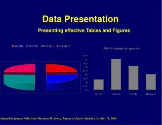
Presenting data There are lots of different presentation techniques........you need to use a VARIETY and APPROPRIATE types of presentation techniques Tables Pie charts Bar graphs Divided Bar Line Scatter graphs Diagrams- Annotated Photos- Annotated Maps
Tips Make sure you include CLEAR titles, scales, units, and keys
Photo south of the rock groyne to show erosion of the coastline Recent slumping that has taken place Variation in colour of boulder clay- light colour where water has drained through to bottom layers Steeper slope to cliff Boulders broken off from boulder clay cliffs- will form seas attack via abrasion removing further cliff Bottom layers- dark brown in colour- water drained to bottom so will become heavier leading to slumping- water also gets in from high tide
Photo of sea defence and evidence of longshore drift Rock groyne made of granite- from Norway- creates a barrier to build up the beach at south end of beach People at north side of barrier over 2 metres higher than beach on south side of beach
Rock groyne at north of site to help trap sediment and build up a beach Strand line
Vegetated slope means less water stays in the slope to create slumping Vegetated slope- shallower profile near south site Rock armour at base of cliff slope to protect against erosion