Download
1 / 7
70 likes | 79 Views
In this study examine the groundwater and rainfall variability, seasonal variation of rain fall using gis technics, The maximum rainfall was recorded at Harohalli 71.80 , having the monthly and annual average respectively. Similarly the minimum rainfall was at Dharmapuri in 61 average value. The monthly rainfall curve has its peak during October and lowest point during January. SW monsoon and NE monsoon almost play an equal role in their rainfall contributions, whereas the post monsoon rainfall occurrence is negligible in this region. Gangadhara G "Analysis on Spatial Variation of Rainfall and Groundwater Fluctuation in Hebballa Watershed, Mysore District, Karnataka, India" Published in International Journal of Trend in Scientific Research and Development (ijtsrd), ISSN: 2456-6470, Volume-2 | Issue-1 , December 2017, URL: https://www.ijtsrd.com/papers/ijtsrd8214.pdf Paper URL: http://www.ijtsrd.com/humanities-and-the-arts/geography/8214/analysis-on-spatial-variation-of-rainfall-and-groundwater-fluctuation-in-hebballa-watershed-mysore-district-karnataka-india/gangadhara-g<br>

E N D
International Research Research and Development (IJTSRD) International Open Access Journal International Open Access Journal International Journal of Trend in Scientific Scientific (IJTSRD) ISSN No: 2456 - 6470 | www.ijtsrd.com | Volume Analysis on Spatial Variation of Rainfall and Groundwater Fluctuation in Analysis on Spatial Variation of Rainfall and Groundwater Fluctuation in ISSN No: 2456 | www.ijtsrd.com | Volume - 2 | Issue – 1 Analysis on Spatial Variation of Rainfall and Groundwater Fluctuation in Hebballa Watershed, Mysore District, Karnataka, India Hebballa Watershed, Mysore District, Karnataka, India Hebballa Watershed, Mysore District, Karnataka, India Gangadhara G Research Scholar Dr. Subash. S. Sannasiddannanavr Associate Professor Department of Studies in Manasagangotri University of Mysore University of Mysore Sannasiddannanavr Associate Professor tudies in Geography Department of Studies in Geography Manasagangotri University of Mysore Manasagangotri University of Mysore eography ABSTRACT The study covers the groundwater level variability analysis and its relationship with rainfall for the Hebballa watershed of Mysore district, Karnataka. Through Geographical Information System (GIS) technique. The rainfall data from the study area for a period of ten years were analyzed annually and categorized based on the seasons: Pre monsoon Jan to march , Southwest monsoon (Jun. to Aug ),Northeast monsoon (Oct. to Dec.). By conventional method, the annual rainfall is found to be 1446mm, of which the post monsoon, pre monsoon, SW monsoon and NE monsoon are 298.mm, 2274mm,and 784.10mm average rain fall received respectively. These results were taken into GIS platform and the spatial distribution maps prepared. From these spatial distribution maps for the seasons, annual average rainfall was prepared. The maximum rainfall was recorded at Harohalli 71.80%, having the monthl annual average respectively. Similarly the minimum rainfall was at Dharmapuri in 61% average value. The monthly rainfall curve has its peak during October and nadir during January. SW monsoon and NE monsoon almost play an equal role in their rainfall whereas the post monsoon rainfall occurrence is negligible in this region The study covers the groundwater level variability analysis and its relationship with rainfall for the of Mysore district, Karnataka. Through Geographical Information System (GIS) technique. The rainfall data from the study area for a period of ten years were analyzed annually and categorized based on the seasons: Pre monsoon Jan to on (Jun. to Aug ),Northeast monsoon (Oct. to Dec.). By conventional method, the annual rainfall is found to be 1446mm, of which the post monsoon, pre monsoon, SW monsoon and NE monsoon are 298.mm, 2274mm,and 784.10mm INTRODUCTION More than 80% of the annual rainfall occurs during the monsoon periods in Karnataka. The main component of the water cycle is rainfall which is the ground water re-charge. A tropical country like India mainly depends on rainfall for filling the water resources. In India, the distribution of rainfall varies from place to place owing to different physiographic and climatic setting. Hence, it throws an enormous challenge to the management of water resources. Improper or ineffective management could lead to fresh water crisis and environmental degradation, and deprive millions of people of the access to safe drinking water. Since the intensity of monsoon rainfall is erratic and uneven both in space and time, it results in drought over major parts of Karnataka during the non periods. Hence it is a necessity to analysis the occurrence of rainfall fluctuations during various seasons for evolving a system which can address these issues. Three main characteristics of rainfall are its amount, frequency, and intensity. For the values of which vary from place to place, day to day, month to month and even year to year, accurate knowledge of these three main characteristics is essential for planning its full utilization . More than 80% of the annual rainfall occurs during the monsoon periods in Karnataka. The main component of the water cycle is rainfall which is the prime source of charge. A tropical country like India mainly depends on rainfall for filling the water resources. In India, the distribution of rainfall varies from place to place owing to different physiographic e, it throws an enormous challenge to the management of water resources. Improper or ineffective management could lead to fresh water crisis and environmental degradation, and deprive millions of people of the access to safe drinking sity of monsoon rainfall is erratic and uneven both in space and time, it results in drought over major parts of Karnataka during the non-monsoon periods. Hence it is a necessity to analysis the occurrence of rainfall ing various seasons for evolving a system which can address these issues. ely. These results were taken into GIS platform and the spatial distribution maps prepared. From these spatial distribution maps for the seasons, annual average rainfall was prepared. The maximum rainfall was recorded at Harohalli 71.80%, having the monthly and annual average respectively. Similarly the minimum rainfall was at Dharmapuri in 61% average value. The monthly rainfall curve has its peak during October and nadir during January. SW monsoon and NE monsoon and and groundwater groundwater level level contributions, Three main characteristics of rainfall are its amount, frequency, and intensity. For the values of which vary from place to place, day to day, month to month and accurate knowledge of these three main characteristics is essential for planning its full whereas the post monsoon rainfall occurrence is Keyword: groundwater level variability, distribution of rainfall, Geographical Information System Geographical Information System distribution of [Kumar and Elango ] studied the relationships between [Kumar and Elango ] studied the relationships between rainfall recharge and groundwater level fluctuation with rainfall recharge and groundwater level fluctuation with @ IJTSRD | Available Online @ www.ijtsrd.com @ IJTSRD | Available Online @ www.ijtsrd.com | Volume – 2 | Issue – 1 | Nov-Dec 2017 Dec 2017 Page: 1291
International Journal of Trend in Scientific Research and Development (IJTSRD) ISSN: 2456-6470 respect to the Lower Palar River Basin in Tamil Nadu, India. They prepared hydrographs and isohyetal maps for carrying out an analysis of groundwater level. [Kumar and Ahmed ] studied the seasonal behavior and spatial variability of groundwater levels in a granitic aquifer during the monsoon in Andhra Pradesh, India. It is mentioned that the major portion of rainfall in India occurred during the monsoon season and most of the water-related activities, either natural such as recharge or man-made such as agriculture with groundwater extraction for irrigation, were closely related to this period. Higher or lower rainfall or changes in its spatial and seasonal distribution would influence the spatial and temporal distribution of runoff, soil moisture and groundwater reserves, and would alter/affect the frequency of droughts and floods. Further, temporal change in precipitation distribution will affect cropping patterns and productivity. [Jagannadhasarma ] has analyzed the rainfall pattern of the coastal zone of Krishna Godavari River Basin, Andhra Pradesh, India. He has analysed the annual, monsoon and non monsoon rainfall and spatial and frequency distribution of rainfall intensity. Similarly [Vennila ] studied the rainfall variation in the Vattamalaikarai sub basin in Tamil Nadu. In another study conducted by [Rathod and Aruchamy ] spatial analysis of rainfall variation in Coimbatore District of Tamil Nadu using GIS tool. study area. The occurrence of groundwater and its quality are controlled by rainfall recharge. Since perennial water resources are remote, the agricultural activities in the study area mainly depend upon the rain fall and ground water resources. But to decide what method to be adopted in this study, an attempt had been made to understand that there were several studies carried out in the past which adopted IDW (Inverse Distance Weighted) method to assess the rainfall distribution. Hence this study adopted IDW method to examine year and season wise spatial variation of rainfall using (IDW) method in ArcGIS. STUDY AREA DESCRIPTION The studies are Hebballa watershed falls in the H.D. Kote & Hunsur taluk, Mysuru District. The total area of the study area is about390.80sq.kms. Its located between Latitude 12o 19’12’’N and 120 06’36’’ N and Longitude 76o .16’12’’E and 760.31’12”E covered under the Survey of India (SOI) toposheet numbers are 57D/7, 57D/11, 57D/12 and 57D/8 on 1:50,000 scale. It has an average elevation of about 694mts. The area is bounded in North by Hunsur taluk, in the South by Kodagu district, in the East by Nanjangud and Mysuru taluk. The area as congenial climatic conditions for industrial development Physiographically, the area is moderately undulating with intermitted ridges and valleys. A major valley is seen in the southern part of the area near HonniKuppe Village. Soil is red sandy loamy in most of the areas. Extensive crop lands are seen over the area. The climate of Hunsur and H.D.Kote taluk may be described as semi arid climatic zone which is a product of the interplay of the two opposing air-masses of the southwest and northeast monsoons. By and large, H.D Kote & Hunsur area is having the same climate as of Mysore and is endowed with a delightful or salubrious climate. The present study focuses on Hebballa watershed of Mysore district, Karnataka. assumes greater importance due to larger segment of agriculture depending on it, and this area is a non perennial one, and no-study had been made in the past on this area. In the present study, an attempt has been made to understand the distribution of rainfall in the study area with the objectives of analysing seasonal and spatial variations in rainfall pattern at various rain gauge stations spread over the @ IJTSRD | Available Online @ www.ijtsrd.com | Volume – 2 | Issue – 1 | Nov-Dec 2017 Page: 1292
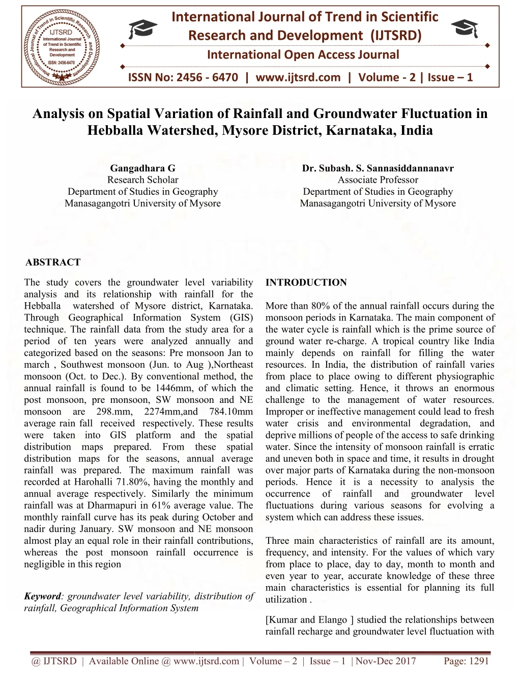
International Journal of Trend in Scientific Research and Development (IJTSRD) ISSN: 2456-6470 LOCATION MAP OF THE HEBBALLA WATERSHED @ IJTSRD | Available Online @ www.ijtsrd.com | Volume – 2 | Issue – 1 | Nov-Dec 2017 Page: 1293
International Journal of Trend in Scientific Research and Development (IJTSRD) ISSN: 2456-6470 MATERIALS AND METHODS. In this study, Survey of India topographical sheets numbers 57D/7, 57D/11, 57D/12 and 57D/8 on 1:50,000 scales were used to delineate the watershed boundary. For analyzing the average depth to water level, and its variability in the study area, the water level data of 10 years (2005-2014) recorded at 6 hydrological stations and the rainfall data of 10 years (2005-20014) for the same place was procured from the Institute of Water Studies of Public Works Department (Government of Karnataka) for the respective periods are used for an analysis of the hydro system. To investigate the changes in rainfall for different seasons, a year was divided into three seasons: pre-monsoon (January -March), Southwest monsoon (June–august), and Northeast monsoon (October–December). Rainfall analysis was carried out for all the seasons as well as the whole year separately. To meet the framed objectives, the collected daily rainfall data has been arranged, interpreted by preparing various graphs and maps. The water level fluctuation was analyzed for the four seasons such as Pre monsoon, South west monsoon and the North east monsoon. In this present, estimating the trend of groundwater level and there after the water level fluctuation and the trend and the increase or decrease in rainfall from the trend of the rainfall data was calculated using average values of water level and rainfall, using Microsoft office Excel 2010. The special variation of seasonal, annual rainfall and groundwater level fluctuations are also prepared using ArcGIS. The spatial coverage maps for each data series were prepared using spatial interpolation techniques available in the spatial analyst module in Arc GIS. monsoon from June to September and northeast monsoon from October to December. Overall on an average, there are 73 normal rainy days, (CGWB report -2012). As per one decade or last ten years (2005-2014) rainfall data of Hebballa watershed area was analyzed. The precipitation during SW monsoon season study area receives 298.58 mm (average of 10 years) and during northeast monsoon it is 274.30 mm (average of 10 years). October is the wettest month in the year. Average annual rainfall for the one decade or last ten years Hebballa watershed receives 784.10 mm. The Hebballa watershed is moist during the rainy and winter season and comes under semi arid area. There are six rain gauge stations are present in Hebballa watershed and received the average annual rainfall 784.10 mm. Average annual and The seasons in the study area has been classified as pre monsoon (jan-May), SW monsoon (June-September), NE monsoon (October –December) and Post monsoon . The Seasonal Variation of Rainfall pattern recorded for the period of ten years (2005-2014) has been analysed for 6 rain gauge station in the study area . The percentage of seasonal rainfall contribution during each station has also been computed . The contribution among the seasons are: the southwest monsoon of 38.8% (298.58 ) ,northeast monsoon of 33.5% (274.30 ) ,Pre monsoon of 25.5% (211.22 mm) and the post monsoon of 3% (27mm) of the total mean annual rainfall. During South west monsoon period, the station Harohalli recorded the maximum average rainfall Dharmapuri recorded the minimum . Results and discussion. Average Annual, Monthly, Seasonal. Rainfall Variation. The annual average rain fall of the study area is 714.80mm; the annual mean varies from 211 mm to 210mm teable1 explains the variation of annual average rainfall over a period of ten years. Harohalli and Kythanhalli eceived rainfall of 71 m%m and 69%mm respectively in the year 2005-2014 which recorded the lowest rainfall. Likewise Chamanahalli and Dharmapuri received rainfall of 61% respectively of the year 2005-2014 with the highest rainfall of the study period. Southwest and northeast monsoon shares 71.6 % of rainfall and summer contributes by 25.5 % and winter shares 2.9%. The spatial variations in rainfall The study area receives rainfall from southwest @ IJTSRD | Available Online @ www.ijtsrd.com | Volume – 2 | Issue – 1 | Nov-Dec 2017 Page: 1294
International Journal of Trend in Scientific Research and Development (IJTSRD) ISSN: 2456-6470 @ IJTSRD | Available Online @ www.ijtsrd.com | Volume – 2 | Issue – 1 | Nov-Dec 2017 Page: 1295
International Journal of Trend in Scientific Research and Development (IJTSRD) ISSN: 2456-6470 @ IJTSRD | Available Online @ www.ijtsrd.com | Volume – 2 | Issue – 1 | Nov-Dec 2017 Page: 1296
International Journal of Trend in Scientific Research and Development (IJTSRD) ISSN: 2456-6470 CONCLUSION It is observed that by the month of January the water level starts lowering and by the month of May, the water level declined to 10m. Although there is substantial amount of rainfall in the south eastern region where the water level is near surface conditions during August, the average depth to water level also deepens by the month of May. This may be due to the hard rock terrain in the region which does not allow water to infiltrate into the deeper aquifer zones, and hence most of the water escapes as runoff and partially gets absorbed into the ground to sustain shallow aquifers. The entire study area can be divided into five groups based on their average annual rainfall distribution. The study of various data series viz., annual, monthly and seasonal indicated that northern part of the state receives higher annual, monsoon and July month rainfall. However, during December, the eastern and the western part of the state receive higher rainfall. Monthly rainfall analysis shows that maximum rain showers are recorded during the month of October and the lowest rainfall intensity is usually recorded during January at all the rain gauge stations located in the study area. From the analysis of seasonal rainfall, it is found that the percentage contributions of rainfall during various monsoon periods are in the following order: SW monsoon (38.87%) > NE monsoon (33.5%) > Pre-monsoon (25.5%) > spatial distribution pattern of rainfall indicates that the magnitude of rainfall increases towards central portion of study area during all the three monsoon (NE monsoon, pre-monsoon and post-monsoon) seasons. However, the magnitude decreases towards north easterly direction during SW monsoon period. Though the contribution of post- monsoon is too minimum, the rainfall intensity is higher in the North portion. As the study area is a hard rock terrain, it is observed that some of the places have deeper water levels during pre-monsoon season. Groundwater starts to replenish the shallow aquifers during SW monsoon season and reaches high during NE monsoon period when plants are dormant and evaporation rates are less. The groundwater levels remain stable for the entire season and a few locations there is a variation of levels due to rainfall variation during pre-monsoon season. References [1] Senthil Kumar, M and Elango, L (2002) Rainfall and groundwater level relationship in a part of the Lower Palar River Basin, Tamil Nadu, and India. In: Proceedings of the International Conference on Sustainable Management of Groundwater Resources in Semi-arid Regions with Special Reference to Hard Rocks, Oxford-IBH, New Delhi, pp 417-422. Groundwater Development and [2] Kumar D and Ahmed S 2003 “Seasonal Behavior of Spatial Variability of Groundwater Level in a Granitic Aquifer in Monsoon Climate”; Current. Sci. 84(2) 188–196 [3] G.Vennila .2007.Rainfall variation analysis of vattamaaikarai sub basin, Tamil Nadu. Journal of applied hydrology.Vol.XX.No.3. pp.5059 [4] V.V.Jagannadha Sarma, 2005.Rainfall pattern in the coastal zone of Krishna Godavari basin Andhra Pradesh India. Journal hydrology.Vol.XVIII.No.1&2 pp111 of applied [5] Rathod , Aruchamy (2010): Spatial Analysis of Rainfall Variation in Coimbatore District Tamilnadu using GIS, INTERNATIONAL JOURNAL OF GEOMATICS AND GEOSCIENCES Volume 1, No 2, pp: 106 – 118 @ IJTSRD | Available Online @ www.ijtsrd.com | Volume – 2 | Issue – 1 | Nov-Dec 2017 Page: 1297