ANALYSIS OF ESTIMATED RAINFALL DATA USING SPATIAL INTERPOLATION.
ANALYSIS OF ESTIMATED RAINFALL DATA USING SPATIAL INTERPOLATION. Preethi Raj GEOG 5650 (Environmental Applications of GIS). INTRODUCTION. Current research in Hydrology emphasizes on ability to forecast hydrologic parameters. Precipitation. Evapo-transipiration. Infiltration. Stream flow.

ANALYSIS OF ESTIMATED RAINFALL DATA USING SPATIAL INTERPOLATION.
E N D
Presentation Transcript
ANALYSIS OF ESTIMATED RAINFALL DATA USING SPATIAL INTERPOLATION. Preethi Raj GEOG 5650 (Environmental Applications of GIS)
INTRODUCTION • Current research in Hydrology emphasizes on ability to forecast hydrologic parameters. Precipitation Evapo-transipiration Infiltration Stream flow Hydrologic Cycle Environmental Application of GIS Spring 06
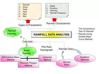
PROBLEMS • Precipitation plays an important role in Hydrologic cycle. • Need for precipitation data to have a better understanding of Hydrologic cycle. • Due to practical difficulties not possible to have rain gauges all over the world. • Need for an alternative to estimate precipitation data. Environmental Application of GIS Spring 06
STUDY AREA - USA • Total number of stations = 6322 Environmental Application of GIS Spring 06
STUDY AREA - USA • Number of stations selected = 1904 Environmental Application of GIS Spring 06
PROCESSES SPATIAL INTERPOLATION • Kriging Interpolation • Inverse Distance Weighted interpolation Environmental Application of GIS Spring 06
KRIGING Environmental Application of GIS Spring 06
KRIGING • PREDICTION STANDARD ERROR MAP Environmental Application of GIS Spring 06
INVERSE DISTANCE WEIGHTED IDW POWER - 3 IDW POWER- 2 IDW POWER - 4 IDW POWER - 5 Environmental Application of GIS Spring 06
ANALYSIS • TENNESSEE • ALABAMA SELECTED STATIONS = 62 UNSELECTED STATIONS = 148 = SELECTED STATION = UNSELECTED STATION Environmental Application of GIS Spring 06
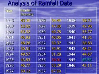
RESULTS Environmental Application of GIS Spring 06
RESULTS Environmental Application of GIS Spring 06
CONCLUSIONS • Values obtained using Kriging, IDW- Power 2 & 3 gives similar values and closer to actual precipitation value. • Difference in values obtained using IDW –Power 5 is high. Environmental Application of GIS Spring 06
ANY QUESTIONS ? THANK YOU Environmental Application of GIS Spring 06