Download
1 / 17
170 likes | 195 Views
Delve into the intricate world of cartography, exploring techniques, distortions, and transformations in creating maps. Learn about map projections and how they impact shape, area, distance, and direction. Discover the fascinating blend of science and art behind spatial representation.

E N D
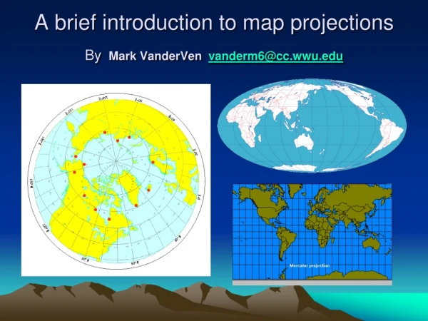
A brief introduction to map projectionsByMark VanderVen vanderm6@cc.wwu.edu
Cartography No simple, easy definition We’ll define it as the study, science, history, and art of map-making.
Cartography • Comprised of many techniques and methods. • Includes measuring the earth's shape, distances, and features • Collect and store information about terrain, places and people • Create and design processes for graphical representation of data • Print and publish spatial information. • Adapt three-dimensional features to flat models
A spherical surface (or section of) cannot be transformed to a planar (flat) surface without incurring some distortion
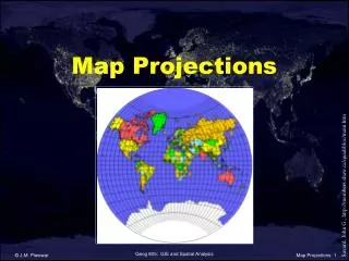
Projection “A mathematical development of one surface onto another. In the cartographic context, one surface is the earth and the other is a flat surface such as a map. The mathematics usually convert from the spherical coordinates of latitude and longitude to a Cartesian coordinate system. The projection is one element of a coordinate system definition.” Norm's GIS Glossaryhttp://www.mentorsoftwareinc.com/resource/glossary.htm
Second Defintion • A map projection is a systematic transformation of the latitudes and longitudes of locations from the surface of a sphere or an ellipsoid into locations on a plane. Maps cannot be created without map projections. All map projections necessarily distort the surface in some fashion. https://www.revolvy.com/main/index.php?s=Orthographic%20projection%20in%20cartography
…more simply put… • A map projection is a flat map surface representing all or part of a spherical surface (Earth).
A spherical surface (or section of) cannot be transformed to a planar (flat) surface without incurring some distortion REMINDER
Map properties that can be distorted • Shape • Area • Distance • Direction
For a web page on coordinate systems see: http://www.colorado.edu/geography/gcraft/notes/coordsys/coordsys.html
Comparisons ESRI “No Projection” (Lat/Long) Mercator
Conclusions Different projections are used to preserve • Shape • Area • Distance • Direction No projection can do all simultaneously.
For More • What on Earth are Map Projections Prof. Alan Saalfeld Geography Ohio State University Click Here for pdf