Download
1 / 30
310 likes | 438 Views
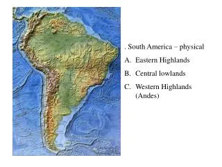
CNS/ATM in South America. Authors: Alessandro Anzaloni Fernando Walter Andréa Ferreira Diego Méndez Castillo. Outline:. The South American Environment VDL 2 and GPS in South America Deployment Timescale. The South American Environment. Main Traffic Flows.

E N D
CNS/ATM in South America Authors: Alessandro AnzaloniFernando WalterAndréa Ferreira Diego Méndez Castillo ATN 2001
Outline: • The South American Environment • VDL 2 and GPS in South America • Deployment Timescale
The South American Environment Main Traffic Flows
The Present ATS – Air Traffic Service Tributary ACC/FIC dependency Principal Center (XX) Maximum number of communication
Main Characteristics: • Satellite communication • Analog voice communication Disadvantages: • Difficult expansion • Little frequency spectrum for data • A new digital communication network is needed to support the technical requirements of future CNS/ATM system
GREPECAS “CAR/SAM Regional Planning and Implementation Group” • Created to achieve interregional • harmonization in the implementation of • CNS/ATM in the CAR/SAM region
Status of Implementation(CAR/SAM/3-WP/7) 0.69 of recommendations completed
Interregional Coordination and Harmonization An example: specific implementation problems in the CAR/SAM Regional Air Navigation Plan, Part MET
Table Met 2 Regular ExchangesNon-regular Exchanges ( 5 flights per week): ( 5 flights per week) T = Aerodrome Forecasts t = Aerodrome Forecasts F = Meteorological Reports and Aerodrome Forecasts
ACARS Most of SAM regions are involved in the implementation of ACARS • Frequency range: VHF (118.0 – 136.975 MHz) • Modulation: AM-MSK • Throughput: 2.4 kbps • MAC: CSMA no-persistent • Data link protocol: Stop-and-Wait • Air-ground communication • Caracter-oriented Protocol
ACARS in Brazil Santarém Belém Boa Vista Jacareacanga Manaus Fernando de Noronha Fortaleza Tabatinga Porto Velho Recife Rio Branco Implemented DEPV’s RGS Implemented SITA’s RGS Planned RGS Petrolina Barreiras Alta Floresta Salvador Cuiabá B.Jesus da Lapa Porto Seguro Campo Grande Brasília Conc. do Araguaia Curitiba Belo Horizonte Foz do Iguaçu Rio de janeiro Guarulhos Porto Alegre Campinas Rib. Preto
VDL Mode 2 • D8PSK • Throughput: 31.5 kbps • MAC: CSMA p-persistent • Go-back-N • Air-ground communication • Bit-oriented protocol
Simulation Results at ITA • ADS-Maximum response Ttime: 0.5 s • VDL packet size: 8312 bits • Packet delay: 0.264 s (considering 31.5 kbps) • To achieve requirement, the maximum delay =0.236 s (SNR, Number of stations) • For SNR = 30dB, Maximum number of stations = 59 • For applications with response time required (ADS and DLIC), there must be a relationship between packet size, SNR and number of stations
GPS • CNS/ATM Environment in SAM • ADS Experiment • Pseudo-range Models • Doppler ShiftMonitoring • GPS Service Integrity Control • Airport Lab • Others
“TEST BED” in SAM /CAR Region MASTER STATION USA MASTER STATION USA HONDURAS BOGOTA MANAUS RECIFE BRASILIA LIMA LAPAZ ANTOFAGASTA RIO DE JANEIRO CURITIBA Master Station SANTIAGO BUENOS AIRES Reference Station VHF-DL Station BALMACEDA UP-LINK Station
Pseudorange Modelling SV real(Xr,Yr,Zr) SV calculated (Xs,Ys,Zs) Ionosphere Troposphere Reference (ITA) (Xu, Yu, Zu) Post -processing Real Time
GPS Service Integrity: Monitoring Reference Site (Xr, Yr, Zr)
GPS Service Integrity: Monitoring Pseudolite 2 (X2, Y2, Z2) Reference Site (Xr, Yr, Zr) Pseudolite 1 (X1, Y1, Z1)
Airport Laboratory • By using the existent infrastructure and facilities at São José dos Campos (SP,Brazil), it is possible to train SAM region personnel in: • LAAS • Pseudolites (Pseudo-satellites) • Integrity Control and Regional Nav. Centers • GNSS • CNS-ATM
Acknowledgments This Project is partialy sponsered by the ICAO BRA-95/805 Objective 6 and by CTA/DEPV projects.